Sibley Volcanic Regional Preserve
About Sibley Volcanic Regional Preserve
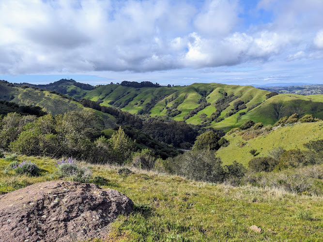
Description
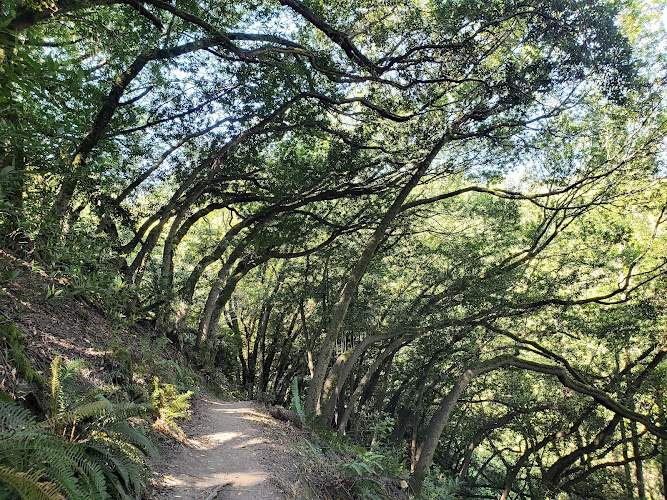
The Sibley Volcanic Regional Preserve sits on top of what used to be a fiery, molten landscape millions of years ago. And honestly, when you first arrive, you might not immediately realize you're standing on the remnants of an ancient volcano – but that's part of what makes this place so fascinating. The preserve sprawls across the East Bay hills, offering visitors a chance to walk through geological history while enjoying some pretty spectacular views of the San Francisco Bay Area. I remember my first visit here, and I'll admit I wasn't expecting much. Just another regional park, right? But then I started noticing the volcanic rock formations, the unusual terrain, and suddenly it clicked – this whole area was once an active volcanic center. The preserve covers about 660 acres of this extinct volcano, which geologists believe was active around 10 million years ago during the Miocene epoch. Now it's a peaceful haven for hikers, families, and anyone curious about the Earth's dramatic past. What really sets Sibley apart from other East Bay preserves is that self-guided volcanic tour. The park provides interpretive information that helps visitors understand what they're looking at – the volcanic rocks, the lava flows, even a quarry pit that exposed the ancient volcanic deposits. It's like having a geology lesson without sitting in a classroom, and you get fresh air and exercise thrown in for free. The terrain here is more varied than you'd expect. You'll find grasslands, eucalyptus groves, and pockets of native oak woodland. The trails wind through different ecosystems, and depending on the season, you might spot wildflowers, hawks circling overhead, or deer grazing in the meadows. Dogs are welcome too, which always makes me happy – though you'll need to keep them leashed, which makes sense given the wildlife and other visitors sharing the space.Key Features
- Self-guided volcanic tour that takes visitors through the remains of a 10-million-year-old volcano, complete with exposed lava flows and volcanic rock formations that tell the story of the area's explosive past
- Multiple hiking trails ranging from easy strolls to more challenging routes, with the Round Top Loop Trail being particularly popular for its panoramic views of the Bay Area, Mount Diablo, and on clear days, even the Sierra Nevada
- An abandoned quarry site that now serves as an outdoor geology classroom, where layers of volcanic ash and lava are clearly visible in the excavated walls
- Wheelchair accessible entrance and parking areas, making the preserve more inclusive for visitors with mobility considerations
- Designated picnic areas with tables where families can settle in for lunch while enjoying views that stretch across the bay
- Free parking lot with ample space, which is honestly a blessing in the Bay Area where parking can be a nightmare
- Public restrooms available on-site, a practical amenity that's often overlooked but genuinely appreciated on longer visits
- Dog-friendly trails throughout the preserve, allowing four-legged companions to join the adventure on leash
- Kid-friendly hiking options that aren't too strenuous, making it perfect for introducing children to both hiking and earth science
- Relatively uncrowded compared to some of the more popular East Bay parks, offering a quieter nature experience even on weekends
Best Time to Visit
Here's the thing about timing your visit to Sibley – it really depends on what kind of experience you're after. Spring, particularly March through May, is absolutely gorgeous. The hillsides explode with wildflowers, the grass is still green from winter rains, and the temperatures are perfect for hiking. You won't be sweating through your shirt, and you won't be shivering either. I've found that April hits that sweet spot where everything just feels alive. But let me tell you about fall too, because September through November has its own charm. The summer fog has mostly cleared out, giving you those crystal-clear days where visibility is incredible. You can see forever from the ridgelines. The temperatures cool down from the summer heat, making longer hikes much more pleasant. And the light – photographers will understand this – the autumn light in California is just different, softer somehow. Winter isn't a bad option either, especially if you don't mind the possibility of rain. The preserve gets muddy, sure, but it's also quieter, and there's something peaceful about hiking through misty hills. Just check the weather forecast and maybe avoid the days right after heavy storms when trails can be pretty slick. Summer can be tricky. July and August get hot, and I mean really hot some days. The grass turns golden-brown, which has its own beauty, but you'll want to start your hike early in the morning before the heat peaks. Bring extra water – more than you think you'll need. For the volcanic tour specifically, any time works since the rocks aren't going anywhere. However, clearer weather means better visibility of the geological features and the interpretive signs are easier to read when they're not being pelted with rain. Weekday mornings tend to be the quietest times if you prefer solitude. Weekend afternoons see more families and groups, though it never gets truly crowded like some of the more famous Bay Area parks.How to Get There
Getting to Sibley Volcanic Regional Preserve is relatively straightforward, though the roads can be a bit winding once you get into the hills. The preserve sits in the East Bay hills, straddling the border between Oakland and Orinda. Most visitors drive, and you'll want to follow Skyline Boulevard, which runs along the ridgeline of the East Bay hills. If you're coming from Oakland or Berkeley, head east toward the hills and make your way to Skyline Boulevard. The main entrance and parking lot are right off Skyline, and there's good signage so you won't miss it. The parking area is free, which I've mentioned before but it bears repeating because that's increasingly rare around here. From the south or east, you can take Highway 13 north and connect to Skyline Boulevard. The roads through this area are scenic but they do twist and turn, so take your time and enjoy the drive. It's part of the experience honestly. Public transportation is possible but not particularly convenient. AC Transit does run buses along routes that get you into the hills, but you'll likely need to do some walking from the nearest stop. It's doable for the adventurous, but most people find driving much more practical. Parking fills up on nice weekend days, particularly in spring when everyone remembers how much they love being outside. Arriving before 10 AM usually guarantees a spot. If the main lot is full, there are a few pullouts along Skyline where people park, though these fill quickly too. The preserve has multiple access points, but the main entrance off Skyline Boulevard is where you'll find the restrooms, picnic areas, and the start of the volcanic tour. Other entrances connect to neighboring parks and preserves, which is great if you're planning a longer adventure through the East Bay Regional Park system.Tips for Visiting
Bring layers, and I can't stress this enough. The East Bay hills have their own microclimate situation going on. You might start your hike in sunshine and end up in fog twenty minutes later. Or it'll be cool in the shade and surprisingly warm in exposed areas. I usually wear a t-shirt with a light jacket tied around my waist, ready to adjust as needed. Water is essential. There's no water available on the trails themselves, and even on mild days you'll work up a thirst. I carry more than I think I'll need because I've been caught short before and it's not fun. The volcanic tour is self-guided, which means you'll want to pick up information at the trailhead or download it beforehand if available. Taking time to actually read the interpretive information makes the whole experience so much richer. Otherwise you're just looking at rocks, and while they're interesting rocks, understanding their story is what makes them amazing. Wear decent shoes. The trails aren't particularly technical, but there are rocky sections and some slopes. Regular athletic shoes work fine – you don't need serious hiking boots – but flip-flops or sandals will make for an uncomfortable day. If you're bringing kids, the shorter loop trails are perfect for little legs. The volcanic features near the main entrance are accessible without committing to a long hike. Kids seem to love the idea that they're walking on a volcano, even if it's been extinct for millions of years. Dogs must stay on leash, and please actually follow this rule. There's wildlife here, and not everyone is comfortable around off-leash dogs. Plus the preserve staff can cite you if they catch your dog running free. Bring water for your pup too – they get thirsty just like we do. The restrooms are near the parking area, so use them before heading out on longer trails. There aren't facilities out on the trail system itself. Cell phone coverage can be spotty in some areas of the preserve. Don't count on having service if you get turned around. Carry a physical map or download trail maps before you arrive. Consider combining your visit with stops at neighboring parks. The East Bay Regional Parks system is interconnected in many places, and if you're up for a longer day, you can explore beyond Sibley's boundaries. Photography enthusiasts should bring a camera. The geological features are photogenic, and the views from the ridges offer great opportunities for landscape shots. Early morning and late afternoon light works best for most photography here. Check for any trail closures or maintenance work before you visit, especially after winter storms. The regional parks website usually has current information about trail conditions. And here's something nobody tells you – there are actually some quiet spots in the preserve where you can sit and hear almost nothing but wind and birds. In the Bay Area, that's a rare gift. Find one of these spots, sit for a few minutes, and just breathe. That's when you really understand why places like Sibley matter.Key Features
- Exposed volcanic core and lava outcrops (Round Top)
- Unstaffed visitor center with geology exhibits and self-guided trail map
- Bay Area Ridge Trail segments and panoramic hilltop views
- Diverse habitats: oak woodlands, chaparral, and seasonal wildflowers
- Relatively short, varied trails suitable for families and geology enthusiasts
More Details
Updated January 17, 2026
Table of Contents
Description
The Sibley Volcanic Regional Preserve sits on top of what used to be a fiery, molten landscape millions of years ago. And honestly, when you first arrive, you might not immediately realize you’re standing on the remnants of an ancient volcano – but that’s part of what makes this place so fascinating. The preserve sprawls across the East Bay hills, offering visitors a chance to walk through geological history while enjoying some pretty spectacular views of the San Francisco Bay Area.
I remember my first visit here, and I’ll admit I wasn’t expecting much. Just another regional park, right? But then I started noticing the volcanic rock formations, the unusual terrain, and suddenly it clicked – this whole area was once an active volcanic center. The preserve covers about 660 acres of this extinct volcano, which geologists believe was active around 10 million years ago during the Miocene epoch. Now it’s a peaceful haven for hikers, families, and anyone curious about the Earth’s dramatic past.
What really sets Sibley apart from other East Bay preserves is that self-guided volcanic tour. The park provides interpretive information that helps visitors understand what they’re looking at – the volcanic rocks, the lava flows, even a quarry pit that exposed the ancient volcanic deposits. It’s like having a geology lesson without sitting in a classroom, and you get fresh air and exercise thrown in for free.
The terrain here is more varied than you’d expect. You’ll find grasslands, eucalyptus groves, and pockets of native oak woodland. The trails wind through different ecosystems, and depending on the season, you might spot wildflowers, hawks circling overhead, or deer grazing in the meadows. Dogs are welcome too, which always makes me happy – though you’ll need to keep them leashed, which makes sense given the wildlife and other visitors sharing the space.
Key Features
- Self-guided volcanic tour that takes visitors through the remains of a 10-million-year-old volcano, complete with exposed lava flows and volcanic rock formations that tell the story of the area’s explosive past
- Multiple hiking trails ranging from easy strolls to more challenging routes, with the Round Top Loop Trail being particularly popular for its panoramic views of the Bay Area, Mount Diablo, and on clear days, even the Sierra Nevada
- An abandoned quarry site that now serves as an outdoor geology classroom, where layers of volcanic ash and lava are clearly visible in the excavated walls
- Wheelchair accessible entrance and parking areas, making the preserve more inclusive for visitors with mobility considerations
- Designated picnic areas with tables where families can settle in for lunch while enjoying views that stretch across the bay
- Free parking lot with ample space, which is honestly a blessing in the Bay Area where parking can be a nightmare
- Public restrooms available on-site, a practical amenity that’s often overlooked but genuinely appreciated on longer visits
- Dog-friendly trails throughout the preserve, allowing four-legged companions to join the adventure on leash
- Kid-friendly hiking options that aren’t too strenuous, making it perfect for introducing children to both hiking and earth science
- Relatively uncrowded compared to some of the more popular East Bay parks, offering a quieter nature experience even on weekends
Best Time to Visit
Here’s the thing about timing your visit to Sibley – it really depends on what kind of experience you’re after. Spring, particularly March through May, is absolutely gorgeous. The hillsides explode with wildflowers, the grass is still green from winter rains, and the temperatures are perfect for hiking. You won’t be sweating through your shirt, and you won’t be shivering either. I’ve found that April hits that sweet spot where everything just feels alive.
But let me tell you about fall too, because September through November has its own charm. The summer fog has mostly cleared out, giving you those crystal-clear days where visibility is incredible. You can see forever from the ridgelines. The temperatures cool down from the summer heat, making longer hikes much more pleasant. And the light – photographers will understand this – the autumn light in California is just different, softer somehow.
Winter isn’t a bad option either, especially if you don’t mind the possibility of rain. The preserve gets muddy, sure, but it’s also quieter, and there’s something peaceful about hiking through misty hills. Just check the weather forecast and maybe avoid the days right after heavy storms when trails can be pretty slick.
Summer can be tricky. July and August get hot, and I mean really hot some days. The grass turns golden-brown, which has its own beauty, but you’ll want to start your hike early in the morning before the heat peaks. Bring extra water – more than you think you’ll need.
For the volcanic tour specifically, any time works since the rocks aren’t going anywhere. However, clearer weather means better visibility of the geological features and the interpretive signs are easier to read when they’re not being pelted with rain.
Weekday mornings tend to be the quietest times if you prefer solitude. Weekend afternoons see more families and groups, though it never gets truly crowded like some of the more famous Bay Area parks.
How to Get There
Getting to Sibley Volcanic Regional Preserve is relatively straightforward, though the roads can be a bit winding once you get into the hills. The preserve sits in the East Bay hills, straddling the border between Oakland and Orinda. Most visitors drive, and you’ll want to follow Skyline Boulevard, which runs along the ridgeline of the East Bay hills.
If you’re coming from Oakland or Berkeley, head east toward the hills and make your way to Skyline Boulevard. The main entrance and parking lot are right off Skyline, and there’s good signage so you won’t miss it. The parking area is free, which I’ve mentioned before but it bears repeating because that’s increasingly rare around here.
From the south or east, you can take Highway 13 north and connect to Skyline Boulevard. The roads through this area are scenic but they do twist and turn, so take your time and enjoy the drive. It’s part of the experience honestly.
Public transportation is possible but not particularly convenient. AC Transit does run buses along routes that get you into the hills, but you’ll likely need to do some walking from the nearest stop. It’s doable for the adventurous, but most people find driving much more practical.
Parking fills up on nice weekend days, particularly in spring when everyone remembers how much they love being outside. Arriving before 10 AM usually guarantees a spot. If the main lot is full, there are a few pullouts along Skyline where people park, though these fill quickly too.
The preserve has multiple access points, but the main entrance off Skyline Boulevard is where you’ll find the restrooms, picnic areas, and the start of the volcanic tour. Other entrances connect to neighboring parks and preserves, which is great if you’re planning a longer adventure through the East Bay Regional Park system.
Tips for Visiting
Bring layers, and I can’t stress this enough. The East Bay hills have their own microclimate situation going on. You might start your hike in sunshine and end up in fog twenty minutes later. Or it’ll be cool in the shade and surprisingly warm in exposed areas. I usually wear a t-shirt with a light jacket tied around my waist, ready to adjust as needed.
Water is essential. There’s no water available on the trails themselves, and even on mild days you’ll work up a thirst. I carry more than I think I’ll need because I’ve been caught short before and it’s not fun.
The volcanic tour is self-guided, which means you’ll want to pick up information at the trailhead or download it beforehand if available. Taking time to actually read the interpretive information makes the whole experience so much richer. Otherwise you’re just looking at rocks, and while they’re interesting rocks, understanding their story is what makes them amazing.
Wear decent shoes. The trails aren’t particularly technical, but there are rocky sections and some slopes. Regular athletic shoes work fine – you don’t need serious hiking boots – but flip-flops or sandals will make for an uncomfortable day.
If you’re bringing kids, the shorter loop trails are perfect for little legs. The volcanic features near the main entrance are accessible without committing to a long hike. Kids seem to love the idea that they’re walking on a volcano, even if it’s been extinct for millions of years.
Dogs must stay on leash, and please actually follow this rule. There’s wildlife here, and not everyone is comfortable around off-leash dogs. Plus the preserve staff can cite you if they catch your dog running free. Bring water for your pup too – they get thirsty just like we do.
The restrooms are near the parking area, so use them before heading out on longer trails. There aren’t facilities out on the trail system itself.
Cell phone coverage can be spotty in some areas of the preserve. Don’t count on having service if you get turned around. Carry a physical map or download trail maps before you arrive.
Consider combining your visit with stops at neighboring parks. The East Bay Regional Parks system is interconnected in many places, and if you’re up for a longer day, you can explore beyond Sibley’s boundaries.
Photography enthusiasts should bring a camera. The geological features are photogenic, and the views from the ridges offer great opportunities for landscape shots. Early morning and late afternoon light works best for most photography here.
Check for any trail closures or maintenance work before you visit, especially after winter storms. The regional parks website usually has current information about trail conditions.
And here’s something nobody tells you – there are actually some quiet spots in the preserve where you can sit and hear almost nothing but wind and birds. In the Bay Area, that’s a rare gift. Find one of these spots, sit for a few minutes, and just breathe. That’s when you really understand why places like Sibley matter.
Key Highlights
- Exposed volcanic core and lava outcrops (Round Top)
- Unstaffed visitor center with geology exhibits and self-guided trail map
- Bay Area Ridge Trail segments and panoramic hilltop views
- Diverse habitats: oak woodlands, chaparral, and seasonal wildflowers
- Relatively short, varied trails suitable for families and geology enthusiasts
Location
Places to Stay Near Sibley Volcanic Regional Preserve
Find and Book a Tour
Explore More Travel Guides
No reviews found! Be the first to review!
Traveler Reviews for Sibley Volcanic Regional Preserve
There are no reviews yet. Be the first one to write one.
Have you visited Sibley Volcanic Regional Preserve? Help other travelers by sharing your review.
Nearby Attractions
You Might Also Like

The Museum of Art and Digital Entertainment – (The MADE)
Huckleberry Botanic Regional Preserve
The Gardens at Lake Merritt
Find Accommodations Nearby
Recommended Tours & Activities
Visitor Reviews
There are no reviews yet. Be the first one to write one.
Share Your Experience
Have you visited Sibley Volcanic Regional Preserve? Help other travelers by leaving a review.