
Santa Rosa Plateau Ecological Preserve
About Santa Rosa Plateau Ecological Preserve
Description
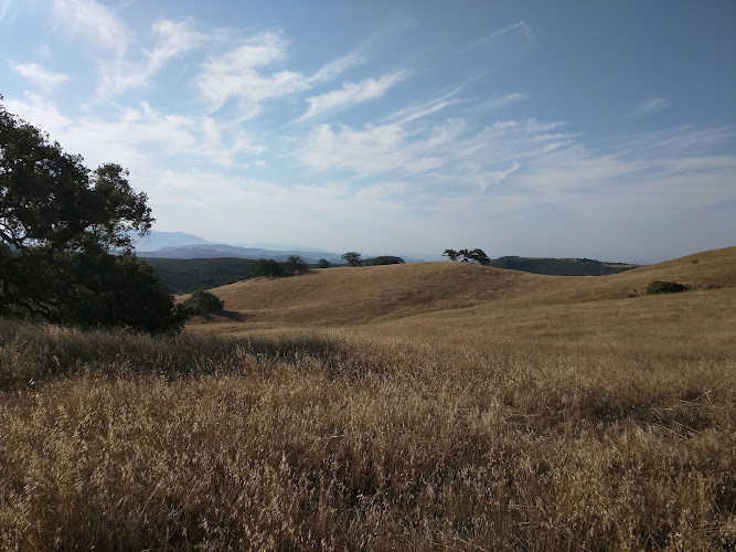
The Santa Rosa Plateau Ecological Preserve is one of those places that makes you wonder how it's managed to stay relatively under the radar in Southern California. Stretching across 9,000 acres of protected land, this ecological gem sits in the foothills between Riverside and San Diego counties, offering a genuine escape from the urban sprawl that characterizes so much of the region. I remember my first visit here – I'd been expecting something pleasant but relatively tame, and instead found myself wandering through landscapes that genuinely surprised me with their diversity and untouched quality. What makes this preserve special isn't just its size, though 9,000 acres is certainly nothing to sneeze at. It's the fact that the terrain changes so dramatically as you explore different sections. You'll encounter rolling grasslands that turn golden in the summer months, ancient oak woodlands where some trees have been standing for centuries, seasonal vernal pools that support rare species, and basalt mesas that offer sweeping views across the countryside. The preserve protects one of the last remaining examples of Southern California's bunchgrass prairie ecosystem, which once covered much of the region before development took over. The visitor center serves as an excellent starting point for understanding what you're about to experience. It's not a massive facility, but it's thoughtfully designed with exhibits that explain the ecological significance of the area without being overly academic or boring. Staff members are typically passionate about the preserve and can offer recommendations based on what you're hoping to see.Key Features
- More than 39 miles of well-maintained hiking trails ranging from easy loops to more challenging terrain that takes you through different ecosystems
- Vernal pools that fill with water during winter and spring, creating unique seasonal wetland habitats that support fairy shrimp and other rare species
- Ancient Engelmann oak woodlands – these trees are a threatened species and the preserve protects one of the finest remaining stands
- Mesa de Colorado and Mesa de Burro, two prominent basalt formations offering panoramic views and interesting geological features
- Abundant wildlife including mountain lions, bobcats, coyotes, mule deer, and over 200 bird species throughout the year
- Seasonal wildflower displays that peak in spring with California poppies, lupines, and dozens of other native species
- The Historic Adobe, a structure from the ranching era that provides context about human history in the area
- Wheelchair-accessible trails and facilities including designated parking areas
- Picnic areas with tables where you can enjoy lunch surrounded by nature
- Educational programs and guided hikes offered throughout the year by knowledgeable docents
Best Time to Visit
Here's where I'm gonna be honest with you – timing really matters at Santa Rosa Plateau, probably more than at many other preserves I've visited. The experience you'll have in July versus March is dramatically different, and neither is necessarily better, just completely distinct. Spring, particularly March through May, is when most people choose to visit, and for good reason. The vernal pools are at their peak, wildflowers carpet the meadows in colors that seem almost too saturated to be real, and the weather is absolutely perfect. Temperatures hover in the 60s and 70s, making hiking comfortable even in the middle of the day. But – and this is important – spring weekends can get crowded by this preserve's standards. You won't be dealing with Disneyland-level crowds, but the parking lot does fill up. I've actually become a bit partial to late fall and winter visits. November through February brings cooler temperatures, sure, but it also brings solitude and a different kind of beauty. The grasslands turn green with winter rains, the air is crisp and clear (offering those long-distance views that summer haze obscures), and you'll often have entire trails to yourself. Morning temperatures can dip into the 40s, so you'll need layers, but by midday it's usually pleasant enough. Summer is the trickiest season here. June through September means heat, sometimes serious heat pushing into the 90s or even higher. The grasslands turn golden-brown, which has its own austere beauty, but hiking becomes an early morning or late afternoon activity unless you enjoy feeling like you're in a convection oven. Water is absolutely essential during summer months, and I mean bring more than you think you'll need. The preserve is open year-round, and honestly, even the "off" seasons have their appeal if you know what to expect and prepare accordingly.How to Get There
Getting to Santa Rosa Plateau requires a car – there's really no way around it. Public transportation doesn't serve this area, which is part of why it remains relatively peaceful and uncrowded compared to more accessible preserves. From the Los Angeles area, you're looking at roughly a 90-minute drive depending on traffic conditions. Take Interstate 15 south toward San Diego, and you'll exit at Clinton Keith Road in Murrieta. Head west on Clinton Keith Road for about five miles until you reach the preserve entrance. The road is well-marked, though I'll admit the first time I visited I second-guessed myself a bit because you're driving through suburban developments and then suddenly there's this massive expanse of protected land. If you're coming from San Diego, the drive is similar in duration, just heading north on Interstate 15 instead. The same Clinton Keith Road exit applies. From Orange County, you can take the 91 East to the 15 South, or if you prefer a slightly more scenic route, the Ortega Highway (74) will eventually connect you, though that adds time and winding roads to your journey. One thing to note – your GPS will get you there, but cell service becomes spotty once you're actually in the preserve. Download any maps or directions beforehand rather than assuming you'll be able to pull them up on the fly. Parking is free, which is a nice bonus. The main visitor center lot has designated accessible parking spaces and can accommodate a decent number of vehicles, though as I mentioned earlier, spring weekends can fill it up.Tips for Visiting
After multiple visits to Santa Rosa Plateau, I've learned a few things that I wish someone had told me before that first trip. First and foremost, bring more water than seems reasonable. There are no water fountains on the trails, and even on mild days, you'll go through liquid faster than expected. I typically bring at least three liters per person for a half-day visit, and I've never regretted having extra. The trails here are shared-use, meaning you'll encounter hikers, mountain bikers, and occasionally equestrians. Everyone's generally courteous, but stay alert and step aside for horses if you encounter them – the riders will appreciate it, and horses can be unpredictable around people they haven't seen before. Wear real hiking boots or at minimum sturdy trail shoes. I've seen people attempt these trails in sandals or casual sneakers, and it rarely looks comfortable. Some sections have rocky terrain, and in spring the vernal pool areas can be muddy. Check the preserve's website before you go for any trail closures or restrictions. They occasionally close certain areas for ecological protection, particularly during sensitive breeding seasons for wildlife. The restrooms are located at the visitor center and main trailhead – there are no facilities once you're out on the trails themselves. Plan accordingly, especially if you're bringing kids. Speaking of kids, this preserve is genuinely family-friendly if you choose appropriate trails. The Vernal Pool Trail is relatively short and flat, perfect for younger children who want to see the unique pool ecosystem without committing to a five-mile trek. That said, keep children close – rattlesnakes are present here, particularly in warmer months. They're not aggressive and will generally move away from people, but teaching kids to watch where they step and never reach into crevices or under rocks is important. Dogs are not allowed on the trails, which disappoints some visitors but honestly makes sense given the preserve's mission to protect sensitive habitats and wildlife. Leave your furry friend at home for this trip. Bring binoculars if you have them. The birdwatching here is excellent, and being able to see raptors, woodpeckers, and other species up close enhances the experience considerably. Don't skip the visitor center, even if you're eager to hit the trails. The exhibits provide context that makes what you're seeing more meaningful, and the staff can provide current conditions and recommendations. Plus, it's a good place to use actual restrooms before committing to a long hike. Sunrise and sunset offer the best lighting for photography, and you'll also see more wildlife during these cooler parts of the day. The preserve opens at dawn, which makes early visits feasible for photographers and serious hikers wanting to avoid midday heat. Finally, pack out everything you pack in. This seems obvious, but I've been surprised by how much trash I've seen on otherwise pristine trails. This preserve exists because people care about protecting these ecosystems – doing your part to keep them clean is the bare minimum we can all contribute.Key Features
- More than 39 miles of well-maintained hiking trails ranging from easy loops to more challenging terrain that takes you through different ecosystems
- Vernal pools that fill with water during winter and spring, creating unique seasonal wetland habitats that support fairy shrimp and other rare species
- Ancient Engelmann oak woodlands – these trees are a threatened species and the preserve protects one of the finest remaining stands
- Mesa de Colorado and Mesa de Burro, two prominent basalt formations offering panoramic views and interesting geological features
- Abundant wildlife including mountain lions, bobcats, coyotes, mule deer, and over 200 bird species throughout the year
- Seasonal wildflower displays that peak in spring with California poppies, lupines, and dozens of other native species
- The Historic Adobe, a structure from the ranching era that provides context about human history in the area
- Wheelchair-accessible trails and facilities including designated parking areas
More Details
Updated March 30, 2026
Table of Contents
- Description
- Key Features
- Best Time to Visit
- How to Get There
- Tips for Visiting
- Key Highlights
- Location
- Places to Stay Near Santa Rosa Plateau Ecological Preserve
- Find and Book a Tour
- Explore More Travel Guides
- Nearby Places You Might Like
- Traveler Reviews for Santa Rosa Plateau Ecological Preserve
- Share Your Experience
Description
The Santa Rosa Plateau Ecological Preserve is one of those places that makes you wonder how it’s managed to stay relatively under the radar in Southern California. Stretching across 9,000 acres of protected land, this ecological gem sits in the foothills between Riverside and San Diego counties, offering a genuine escape from the urban sprawl that characterizes so much of the region. I remember my first visit here – I’d been expecting something pleasant but relatively tame, and instead found myself wandering through landscapes that genuinely surprised me with their diversity and untouched quality.
What makes this preserve special isn’t just its size, though 9,000 acres is certainly nothing to sneeze at. It’s the fact that the terrain changes so dramatically as you explore different sections. You’ll encounter rolling grasslands that turn golden in the summer months, ancient oak woodlands where some trees have been standing for centuries, seasonal vernal pools that support rare species, and basalt mesas that offer sweeping views across the countryside. The preserve protects one of the last remaining examples of Southern California’s bunchgrass prairie ecosystem, which once covered much of the region before development took over.
The visitor center serves as an excellent starting point for understanding what you’re about to experience. It’s not a massive facility, but it’s thoughtfully designed with exhibits that explain the ecological significance of the area without being overly academic or boring. Staff members are typically passionate about the preserve and can offer recommendations based on what you’re hoping to see.
Key Features
- More than 39 miles of well-maintained hiking trails ranging from easy loops to more challenging terrain that takes you through different ecosystems
- Vernal pools that fill with water during winter and spring, creating unique seasonal wetland habitats that support fairy shrimp and other rare species
- Ancient Engelmann oak woodlands – these trees are a threatened species and the preserve protects one of the finest remaining stands
- Mesa de Colorado and Mesa de Burro, two prominent basalt formations offering panoramic views and interesting geological features
- Abundant wildlife including mountain lions, bobcats, coyotes, mule deer, and over 200 bird species throughout the year
- Seasonal wildflower displays that peak in spring with California poppies, lupines, and dozens of other native species
- The Historic Adobe, a structure from the ranching era that provides context about human history in the area
- Wheelchair-accessible trails and facilities including designated parking areas
- Picnic areas with tables where you can enjoy lunch surrounded by nature
- Educational programs and guided hikes offered throughout the year by knowledgeable docents
Best Time to Visit
Here’s where I’m gonna be honest with you – timing really matters at Santa Rosa Plateau, probably more than at many other preserves I’ve visited. The experience you’ll have in July versus March is dramatically different, and neither is necessarily better, just completely distinct.
Spring, particularly March through May, is when most people choose to visit, and for good reason. The vernal pools are at their peak, wildflowers carpet the meadows in colors that seem almost too saturated to be real, and the weather is absolutely perfect. Temperatures hover in the 60s and 70s, making hiking comfortable even in the middle of the day. But – and this is important – spring weekends can get crowded by this preserve’s standards. You won’t be dealing with Disneyland-level crowds, but the parking lot does fill up.
I’ve actually become a bit partial to late fall and winter visits. November through February brings cooler temperatures, sure, but it also brings solitude and a different kind of beauty. The grasslands turn green with winter rains, the air is crisp and clear (offering those long-distance views that summer haze obscures), and you’ll often have entire trails to yourself. Morning temperatures can dip into the 40s, so you’ll need layers, but by midday it’s usually pleasant enough.
Summer is the trickiest season here. June through September means heat, sometimes serious heat pushing into the 90s or even higher. The grasslands turn golden-brown, which has its own austere beauty, but hiking becomes an early morning or late afternoon activity unless you enjoy feeling like you’re in a convection oven. Water is absolutely essential during summer months, and I mean bring more than you think you’ll need.
The preserve is open year-round, and honestly, even the “off” seasons have their appeal if you know what to expect and prepare accordingly.
How to Get There
Getting to Santa Rosa Plateau requires a car – there’s really no way around it. Public transportation doesn’t serve this area, which is part of why it remains relatively peaceful and uncrowded compared to more accessible preserves.
From the Los Angeles area, you’re looking at roughly a 90-minute drive depending on traffic conditions. Take Interstate 15 south toward San Diego, and you’ll exit at Clinton Keith Road in Murrieta. Head west on Clinton Keith Road for about five miles until you reach the preserve entrance. The road is well-marked, though I’ll admit the first time I visited I second-guessed myself a bit because you’re driving through suburban developments and then suddenly there’s this massive expanse of protected land.
If you’re coming from San Diego, the drive is similar in duration, just heading north on Interstate 15 instead. The same Clinton Keith Road exit applies.
From Orange County, you can take the 91 East to the 15 South, or if you prefer a slightly more scenic route, the Ortega Highway (74) will eventually connect you, though that adds time and winding roads to your journey.
One thing to note – your GPS will get you there, but cell service becomes spotty once you’re actually in the preserve. Download any maps or directions beforehand rather than assuming you’ll be able to pull them up on the fly.
Parking is free, which is a nice bonus. The main visitor center lot has designated accessible parking spaces and can accommodate a decent number of vehicles, though as I mentioned earlier, spring weekends can fill it up.
Tips for Visiting
After multiple visits to Santa Rosa Plateau, I’ve learned a few things that I wish someone had told me before that first trip.
First and foremost, bring more water than seems reasonable. There are no water fountains on the trails, and even on mild days, you’ll go through liquid faster than expected. I typically bring at least three liters per person for a half-day visit, and I’ve never regretted having extra.
The trails here are shared-use, meaning you’ll encounter hikers, mountain bikers, and occasionally equestrians. Everyone’s generally courteous, but stay alert and step aside for horses if you encounter them – the riders will appreciate it, and horses can be unpredictable around people they haven’t seen before.
Wear real hiking boots or at minimum sturdy trail shoes. I’ve seen people attempt these trails in sandals or casual sneakers, and it rarely looks comfortable. Some sections have rocky terrain, and in spring the vernal pool areas can be muddy.
Check the preserve’s website before you go for any trail closures or restrictions. They occasionally close certain areas for ecological protection, particularly during sensitive breeding seasons for wildlife.
The restrooms are located at the visitor center and main trailhead – there are no facilities once you’re out on the trails themselves. Plan accordingly, especially if you’re bringing kids.
Speaking of kids, this preserve is genuinely family-friendly if you choose appropriate trails. The Vernal Pool Trail is relatively short and flat, perfect for younger children who want to see the unique pool ecosystem without committing to a five-mile trek. That said, keep children close – rattlesnakes are present here, particularly in warmer months. They’re not aggressive and will generally move away from people, but teaching kids to watch where they step and never reach into crevices or under rocks is important.
Dogs are not allowed on the trails, which disappoints some visitors but honestly makes sense given the preserve’s mission to protect sensitive habitats and wildlife. Leave your furry friend at home for this trip.
Bring binoculars if you have them. The birdwatching here is excellent, and being able to see raptors, woodpeckers, and other species up close enhances the experience considerably.
Don’t skip the visitor center, even if you’re eager to hit the trails. The exhibits provide context that makes what you’re seeing more meaningful, and the staff can provide current conditions and recommendations. Plus, it’s a good place to use actual restrooms before committing to a long hike.
Sunrise and sunset offer the best lighting for photography, and you’ll also see more wildlife during these cooler parts of the day. The preserve opens at dawn, which makes early visits feasible for photographers and serious hikers wanting to avoid midday heat.
Finally, pack out everything you pack in. This seems obvious, but I’ve been surprised by how much trash I’ve seen on otherwise pristine trails. This preserve exists because people care about protecting these ecosystems – doing your part to keep them clean is the bare minimum we can all contribute.
Key Highlights
- More than 39 miles of well-maintained hiking trails ranging from easy loops to more challenging terrain that takes you through different ecosystems
- Vernal pools that fill with water during winter and spring, creating unique seasonal wetland habitats that support fairy shrimp and other rare species
- Ancient Engelmann oak woodlands – these trees are a threatened species and the preserve protects one of the finest remaining stands
- Mesa de Colorado and Mesa de Burro, two prominent basalt formations offering panoramic views and interesting geological features
- Abundant wildlife including mountain lions, bobcats, coyotes, mule deer, and over 200 bird species throughout the year
- Seasonal wildflower displays that peak in spring with California poppies, lupines, and dozens of other native species
- The Historic Adobe, a structure from the ranching era that provides context about human history in the area
- Wheelchair-accessible trails and facilities including designated parking areas
Location
Places to Stay Near Santa Rosa Plateau Ecological Preserve
Find and Book a Tour
Explore More Travel Guides
No reviews found! Be the first to review!
Santa Rosa Plateau Ecological Preserve is a prominent attractions located in Murrieta.
Visit us at: 39400 Clinton Keith Rd, Murrieta, CA 92562, United States.
Traveler Reviews for Santa Rosa Plateau Ecological Preserve
There are no reviews yet. Be the first one to write one.
Have you visited Santa Rosa Plateau Ecological Preserve? Help other travelers by sharing your review.
You Might Also Like

Pump It Up Murrieta Kids Birthdays and More
Mountain Pride Park
Cole Canyon Trail
Find Accommodations Nearby
Recommended Tours & Activities
Visitor Reviews
There are no reviews yet. Be the first one to write one.
Share Your Experience
Have you visited Santa Rosa Plateau Ecological Preserve? Help other travelers by leaving a review.