Parques de Tlaquepaque
About Parques de Tlaquepaque
Description
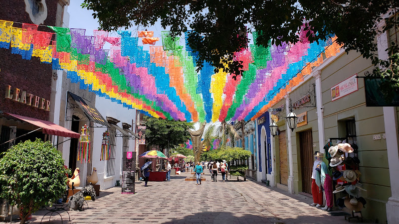
Parques de Tlaquepaque refers to the growing patchwork of green spaces spread across San Pedro Tlaquepaque, Jalisco, right next to Guadalajara. It is a place where ceramics and mariachi meet morning jogs, where murals and tilework share space with jacaranda shade and the soft whirr of cyclists on Sunday. Visitors tend to come for the galleries, but they stay after discovering that Tlaquepaque’s parks are low-key excellent for walking, running, picnicking, and sneaking in short hikes with real viewpoints—yes, actual senderos with a little bit of climb.
The star many locals rave about is Bosque Urbano Tlaquepaque, a community-driven urban forest backed by the Agencia Metropolitana de Bosques Urbanos. It’s a lung on the east side, created through a citizen effort that put down thousands of árboles and carved out space for environmental education. There’s an open-air feel and pieces of art—this writer still smiles at the large, hopeful mural you’ll find on-site—plus a community orchard and learning gardens that give the park a lived-in, loved-in kind of vibe. It’s not a manicured European garden, and that’s the charm. On weekday mornings you’ll see neighbors walking dogs, a few people trotting laps, and kids tracing the paths on scooters while a street vendor warms up a griddle. Simple, but it sticks with you.
Then there’s the more rugged side. Ask about Cerro del Cuatro (also called bosque del cuatro) and you’ll get knowing nods from runners, hikers, and cyclists. The hill rises like a shoulder above the city and hosts a web of dirt tracks and singletrack trails with modest elevation gain. It’s not a giant mountain, but for Guadalajara’s metro area, it wins on access, atmosphere, and that magic moment when the skyline opens up. On ultra-clear days in winter, resilient locals will tell you they’ve spotted far-off silhouettes of Nevado de Colima from higher points; most days, expect wide panoramas of de Guadalajara and the surrounding basin instead. Sunrise up there is a small reward that keeps people coming back—this writer has hustled up before dawn and swears the coffee tastes better afterward.
If you’re chasing neighborhood comfort and kid-friendly amenities, Parque Hundido in Tlaquepaque quietly gets the job done. A walkable loop, a soccer pitch, a couple shaded corners, and generally a calm, local crowd. It’s not flashy, but if you’re staying nearby, it’s a good place to stretch the legs and shake off a long travel day. Smaller neighborhood parks like Parque Natura and Parque Cedros also serve as dependable micro-oases—handy for families, light exercise, and a breather between gallery-hopping and taco pilgrimages. Over in San Martín de las Flores, the path up Cerro de la Cruz is a classic short climb with a shrine at the top; it’s steeper than it looks from below and a nice add-on for travelers who want a 60–90 minute outing without leaving the municipality.
So, are there scenic trails in Tlaquepaque? Absolutely, but they’re urban-adjacent trails: accessible, unsnobby, and used by real neighbors. Visitors looking for best hiking trails in Tlaquepaque will likely start with Cerro del Cuatro for hills and Bosque Urbano Tlaquepaque for a relaxed loop with educational corners and public art. Runners can pull together 5–10 km easily by connecting parks and quiet streets around early morning, when traffic is light. And for those wondering in Spanish, ¿Buscas las mejores rutas de senderismo en Tlaquepaque?, that short list typically includes the Cerro del Cuatro network and the stair-step climbs toward la cruz in San Martín de las Flores.
Is everything perfect? No. Weekend crowds arrive, especially late afternoon. Signage can be inconsistent on some senderos, and after summer rains certain dirt sections get slick. Maintenance ebbs and flows—some corners shine, others show scuffs of daily life. But the parks of Tlaquepaque feel lived in and genuine, and that authenticity tends to win over travelers who like their green spaces with a side of local flavor.
Key Features
-
Bosque Urbano Tlaquepaque
- A citizen-launched urban forest supported by the Agencia Metropolitana de Bosques Urbanos, with thousands of young and maturing árboles and a layout meant for easy walking.
- Community orchard and small educational plots; occasional environmental workshops and activities that bring neighbors into the care of the ecosystem.
- Public art, including a large-scale mural that anchors the identity of the space—colorful, optimistic, and photogenic.
- Flat paths suitable for strollers and casual runs; dog-friendly etiquette is common among locals.
-
Cerro del Cuatro (bosque del cuatro)
- Network of dirt senderos with gentle to moderate gradients; expect 150–300 m of elevation gain depending on your start point and route.
- Expansive city views at sunrise and sunset; rare ultra-clear winter days may hint at volcano silhouettes to the south, but go for urban panoramas first.
- Options for loop runs from 4 km to 10+ km; popular among trail runners looking for quick hill repeats close to town.
-
Parque Hundido (San Pedro Tlaquepaque)
- Neighborhood park with a soccer field and a simple walking circuit—great for light workouts and family downtime.
- Open areas for stretching and informal games; occasional vendors on busy days.
-
Smaller parks and community greens
- Parque Natura and Parque Cedros provide pocket-park shade, benches, and short, easy paths for a quick breather.
- Ojito de Agua and other local plazas offer kid-friendly corners and meet-up points before heading to Tlaquepaque Centro.
-
Running and hiking essentials
- Running trails in Tlaquepaque range from paved loops in urban parks to dirt tracks on the hills; the most elevation gain is usually at Cerro del Cuatro.
- The longest commonly used route in the municipality pushes past 12 km when linking hill segments and lower neighborhoods; casual visitors often prefer 4–8 km loops.
- Surfaces vary from pavement to sandy dirt and rock; proper footwear is recommended.
-
Art, culture, and daily life
- Tile benches, murals, and occasional pop-up activities reflect Tlaquepaque’s creative DNA, giving parks an identity beyond lawns and paths.
- Sunday mornings can coincide with Vía RecreActiva routes that make the streets feel extra friendly for bikes and pedestrians across greater Guadalajara.
-
Wildlife and birding
- Expect city birds like great-tailed grackles, kiskadees, and hummingbirds; rainy season brings more butterflies and greener canopies.
- Keep a respectful distance and pack out all trash to protect local fauna.
-
Practicalities
- Most parks are free to enter; occasional paid parking may apply in larger regional parks outside Tlaquepaque.
- Facilities like restrooms and drinking fountains are not guaranteed in every park; plan ahead, especially for longer hikes.
Best Time to Visit
Tlaquepaque is comfortable most of the year, but the outdoor experience shifts by season. The dry months from November to April are the sweet spot for long walks and hill repeats. Morning temperatures often hover around 12–16°C (54–61°F), with afternoon highs in the mid-20s to low-30s°C (mid-70s to high-80s°F). Air clarity improves after a cold front, and the city skyline looks crisp from Cerro del Cuatro. That’s prime time for photography and those early-bird runs that feel almost meditative.
From June to September, the rainy season paints everything green. Parks look lush, birds are lively, and the smell of wet earth is the unofficial fragrance of Jalisco. But afternoon downpours can arrive suddenly. Dirt trails get slick, and lightning storms, although brief, deserve respect. If visiting then, go early and bring a light rain shell. The payoff: fewer crowds on hot days, softer trails underfoot, and a photogenic contrast between dark clouds and sunlit rooftops.
Travelers who love cultural mashups should consider late June. The Fiestas of San Pedro Tlaquepaque revolve around the feast day of Saint Peter, so the town hums with events, color, music, and pride. It’s busy, yes, but a great time to feel how the parks and plazas link into daily life. If you prefer tranquility, weekday mornings year-round are wonderfully calm—parks feel local and unhurried, and you can actually hear the birds.
How to Get There
San Pedro Tlaquepaque sits just southeast of central Guadalajara, making it straightforward to reach by public transport, rideshare, or taxi. Those staying downtown can hop onto Line 3 of the light rail to Tlaquepaque Centro for an easy jump-off point to parks and the main plaza area. From there, short rides by app get you to neighborhood parks or to the trailheads for Cerro del Cuatro.
If you’re coming from the airport, the drive into Tlaquepaque is typically 20–35 minutes depending on traffic. Many visitors choose ride-hailing apps so they don’t have to navigate parking around popular plazas or narrow streets. For cyclists, gradual approaches to the parks are possible via bike lanes and calmer roads on Sunday mornings; always ride defensively and use lights before sunrise.
Reaching Cerro del Cuatro is easiest by ride-hailing directly to a known access point; locals will mention areas near the antennas or established footpaths. Pick-ups at sunset can be in high demand, so plan your return before you lose your cell signal or daylight. Parque Hundido, Parque Natura, and other neighborhood greens are short rides from Tlaquepaque Centro and often close to cafés and taco stands—ideal for stitching together a park-hop and a casual food crawl.
Tips for Visiting
-
Timing and safety
- Go early. Sunrise and the hour after are the most rewarding times for photos, cooler temperatures, and calmer paths. Evenings are fine too, but allow time to get back before it’s fully dark.
- Stay on obvious senderos, especially on Cerro del Cuatro. Some small paths branch into rough terrain or private parcels; if a route looks sketchy, it probably is.
- In the rainy season, watch your footing on damp clay and rock. Slips happen—trail shoes help a lot.
- Keep valuables tucked away and use common-sense street smarts, as you would in any big metro area.
-
Gear and comfort
- Bring 1–2 liters of water for hill hikes depending on heat. Shade can be intermittent.
- Wear a hat and sunscreen year-round. Even winter sun in Jalisco is punchy.
- If you plan to run, a small waist pack for phone, ID, and cash is handy for quick snack stops afterward.
- Mosquitoes are hit-or-miss, but in the rainy months carry repellent just in case.
-
Route ideas for runners and hikers
- Best hiking trails in Tlaquepaque: start with Cerro del Cuatro loops 4–6 km for first timers; add spurs for a 9–12 km morning. The most elevation gain you’ll find locally tends to be here.
- Looking for running trails? Combine Bosque Urbano Tlaquepaque’s flat paths with quiet surrounding streets at sunrise for a 5–8 km recovery run, or tackle hill repeats on the Cuatro tracks.
- Are there trails with mountain or volcano viewpoints? Think of them as urban viewpoints with distant silhouettes on rare, clear winter mornings. Manage expectations and enjoy the cityscape.
- Parque Hundido sports: easy laps for walking or trotar, a soccer field for informal matches, and casual fitness corners where locals warm up or stretch.
-
Family and culture
- Neighborhood parks shine for families: look for shaded benches, small playgrounds, and open lawns for picnics. Weekday mornings are especially calm for little ones.
- Pair a park visit with Tlaquepaque Centro—mariachi in the plaza, artisan galleries, and excellent food are a short ride away.
- If festivals are on (particularly late June), arrive early to find calm corners, then enjoy the energy as the day builds.
-
Practical notes
- Most parks do not charge entry. Keep small cash for snacks or water from local vendors.
- Trash cans can be spaced out; pack a small bag to carry out your litter. It helps keep the paisaje urbano and trails clean.
- Facilities vary. Larger greens sometimes have restrooms during events, but don’t count on it midweek—plan ahead.
- Download an offline map if you plan to explore senderos around the hills. Signal can blink occasionally.
-
Photography and pacing
- Golden hour on Cerro del Cuatro is the crowd-pleaser, with pastel skies over the Guadalajara basin. Bring a light jacket in winter mornings—it can feel cooler than the forecast.
- Bosque Urbano Tlaquepaque’s mural and tree-lined paths are photo-friendly, especially after the rains when foliage pops and puddles create reflections.
- If you’re short on time, 90 minutes is enough for a loop and a few viewpoint stops. Longer visits let you stitch parks together and linger at a café afterward.
A final thought: Parques de Tlaquepaque aren’t about ticking off famous landmarks. They’re about daily life—catching a breeze under ficus shade, hearing the scuff of a soccer ball at Parque Hundido, jogging a comeback run after a red-eye flight, or climbing a hill because a local told you the view was worth it. And it usually is. These parks stand out because they’re shared spaces shaped by the community. Visitors feel that quickly. Even with the minor scuffs and the occasional muddy patch, the promise is simple: fresh air, honest views, and a quiet slice of Jalisco in motion.
Key Features
- Network of small plazas and larger green spaces (e.g., Bosque Urbano, Parque Belcanto)
- Close proximity to artisan workshops, galleries and pottery markets
- Decorative tilework, murals and colonial-style fountains
- Shaded walking paths and jacaranda-lined streets for seasonal blooms
- Family-friendly amenities: playgrounds, sports courts and weekend events
More Details
Updated November 2, 2025
Table of Contents
Description
Parques de Tlaquepaque refers to the growing patchwork of green spaces spread across San Pedro Tlaquepaque, Jalisco, right next to Guadalajara. It is a place where ceramics and mariachi meet morning jogs, where murals and tilework share space with jacaranda shade and the soft whirr of cyclists on Sunday. Visitors tend to come for the galleries, but they stay after discovering that Tlaquepaque’s parks are low-key excellent for walking, running, picnicking, and sneaking in short hikes with real viewpoints—yes, actual senderos with a little bit of climb.
The star many locals rave about is Bosque Urbano Tlaquepaque, a community-driven urban forest backed by the Agencia Metropolitana de Bosques Urbanos. It’s a lung on the east side, created through a citizen effort that put down thousands of árboles and carved out space for environmental education. There’s an open-air feel and pieces of art—this writer still smiles at the large, hopeful mural you’ll find on-site—plus a community orchard and learning gardens that give the park a lived-in, loved-in kind of vibe. It’s not a manicured European garden, and that’s the charm. On weekday mornings you’ll see neighbors walking dogs, a few people trotting laps, and kids tracing the paths on scooters while a street vendor warms up a griddle. Simple, but it sticks with you.
Then there’s the more rugged side. Ask about Cerro del Cuatro (also called bosque del cuatro) and you’ll get knowing nods from runners, hikers, and cyclists. The hill rises like a shoulder above the city and hosts a web of dirt tracks and singletrack trails with modest elevation gain. It’s not a giant mountain, but for Guadalajara’s metro area, it wins on access, atmosphere, and that magic moment when the skyline opens up. On ultra-clear days in winter, resilient locals will tell you they’ve spotted far-off silhouettes of Nevado de Colima from higher points; most days, expect wide panoramas of de Guadalajara and the surrounding basin instead. Sunrise up there is a small reward that keeps people coming back—this writer has hustled up before dawn and swears the coffee tastes better afterward.
If you’re chasing neighborhood comfort and kid-friendly amenities, Parque Hundido in Tlaquepaque quietly gets the job done. A walkable loop, a soccer pitch, a couple shaded corners, and generally a calm, local crowd. It’s not flashy, but if you’re staying nearby, it’s a good place to stretch the legs and shake off a long travel day. Smaller neighborhood parks like Parque Natura and Parque Cedros also serve as dependable micro-oases—handy for families, light exercise, and a breather between gallery-hopping and taco pilgrimages. Over in San Martín de las Flores, the path up Cerro de la Cruz is a classic short climb with a shrine at the top; it’s steeper than it looks from below and a nice add-on for travelers who want a 60–90 minute outing without leaving the municipality.
So, are there scenic trails in Tlaquepaque? Absolutely, but they’re urban-adjacent trails: accessible, unsnobby, and used by real neighbors. Visitors looking for best hiking trails in Tlaquepaque will likely start with Cerro del Cuatro for hills and Bosque Urbano Tlaquepaque for a relaxed loop with educational corners and public art. Runners can pull together 5–10 km easily by connecting parks and quiet streets around early morning, when traffic is light. And for those wondering in Spanish, ¿Buscas las mejores rutas de senderismo en Tlaquepaque?, that short list typically includes the Cerro del Cuatro network and the stair-step climbs toward la cruz in San Martín de las Flores.
Is everything perfect? No. Weekend crowds arrive, especially late afternoon. Signage can be inconsistent on some senderos, and after summer rains certain dirt sections get slick. Maintenance ebbs and flows—some corners shine, others show scuffs of daily life. But the parks of Tlaquepaque feel lived in and genuine, and that authenticity tends to win over travelers who like their green spaces with a side of local flavor.
Key Features
-
Bosque Urbano Tlaquepaque
- A citizen-launched urban forest supported by the Agencia Metropolitana de Bosques Urbanos, with thousands of young and maturing árboles and a layout meant for easy walking.
- Community orchard and small educational plots; occasional environmental workshops and activities that bring neighbors into the care of the ecosystem.
- Public art, including a large-scale mural that anchors the identity of the space—colorful, optimistic, and photogenic.
- Flat paths suitable for strollers and casual runs; dog-friendly etiquette is common among locals.
-
Cerro del Cuatro (bosque del cuatro)
- Network of dirt senderos with gentle to moderate gradients; expect 150–300 m of elevation gain depending on your start point and route.
- Expansive city views at sunrise and sunset; rare ultra-clear winter days may hint at volcano silhouettes to the south, but go for urban panoramas first.
- Options for loop runs from 4 km to 10+ km; popular among trail runners looking for quick hill repeats close to town.
-
Parque Hundido (San Pedro Tlaquepaque)
- Neighborhood park with a soccer field and a simple walking circuit—great for light workouts and family downtime.
- Open areas for stretching and informal games; occasional vendors on busy days.
-
Smaller parks and community greens
- Parque Natura and Parque Cedros provide pocket-park shade, benches, and short, easy paths for a quick breather.
- Ojito de Agua and other local plazas offer kid-friendly corners and meet-up points before heading to Tlaquepaque Centro.
-
Running and hiking essentials
- Running trails in Tlaquepaque range from paved loops in urban parks to dirt tracks on the hills; the most elevation gain is usually at Cerro del Cuatro.
- The longest commonly used route in the municipality pushes past 12 km when linking hill segments and lower neighborhoods; casual visitors often prefer 4–8 km loops.
- Surfaces vary from pavement to sandy dirt and rock; proper footwear is recommended.
-
Art, culture, and daily life
- Tile benches, murals, and occasional pop-up activities reflect Tlaquepaque’s creative DNA, giving parks an identity beyond lawns and paths.
- Sunday mornings can coincide with Vía RecreActiva routes that make the streets feel extra friendly for bikes and pedestrians across greater Guadalajara.
-
Wildlife and birding
- Expect city birds like great-tailed grackles, kiskadees, and hummingbirds; rainy season brings more butterflies and greener canopies.
- Keep a respectful distance and pack out all trash to protect local fauna.
-
Practicalities
- Most parks are free to enter; occasional paid parking may apply in larger regional parks outside Tlaquepaque.
- Facilities like restrooms and drinking fountains are not guaranteed in every park; plan ahead, especially for longer hikes.
Best Time to Visit
Tlaquepaque is comfortable most of the year, but the outdoor experience shifts by season. The dry months from November to April are the sweet spot for long walks and hill repeats. Morning temperatures often hover around 12–16°C (54–61°F), with afternoon highs in the mid-20s to low-30s°C (mid-70s to high-80s°F). Air clarity improves after a cold front, and the city skyline looks crisp from Cerro del Cuatro. That’s prime time for photography and those early-bird runs that feel almost meditative.
From June to September, the rainy season paints everything green. Parks look lush, birds are lively, and the smell of wet earth is the unofficial fragrance of Jalisco. But afternoon downpours can arrive suddenly. Dirt trails get slick, and lightning storms, although brief, deserve respect. If visiting then, go early and bring a light rain shell. The payoff: fewer crowds on hot days, softer trails underfoot, and a photogenic contrast between dark clouds and sunlit rooftops.
Travelers who love cultural mashups should consider late June. The Fiestas of San Pedro Tlaquepaque revolve around the feast day of Saint Peter, so the town hums with events, color, music, and pride. It’s busy, yes, but a great time to feel how the parks and plazas link into daily life. If you prefer tranquility, weekday mornings year-round are wonderfully calm—parks feel local and unhurried, and you can actually hear the birds.
How to Get There
San Pedro Tlaquepaque sits just southeast of central Guadalajara, making it straightforward to reach by public transport, rideshare, or taxi. Those staying downtown can hop onto Line 3 of the light rail to Tlaquepaque Centro for an easy jump-off point to parks and the main plaza area. From there, short rides by app get you to neighborhood parks or to the trailheads for Cerro del Cuatro.
If you’re coming from the airport, the drive into Tlaquepaque is typically 20–35 minutes depending on traffic. Many visitors choose ride-hailing apps so they don’t have to navigate parking around popular plazas or narrow streets. For cyclists, gradual approaches to the parks are possible via bike lanes and calmer roads on Sunday mornings; always ride defensively and use lights before sunrise.
Reaching Cerro del Cuatro is easiest by ride-hailing directly to a known access point; locals will mention areas near the antennas or established footpaths. Pick-ups at sunset can be in high demand, so plan your return before you lose your cell signal or daylight. Parque Hundido, Parque Natura, and other neighborhood greens are short rides from Tlaquepaque Centro and often close to cafés and taco stands—ideal for stitching together a park-hop and a casual food crawl.
Tips for Visiting
-
Timing and safety
- Go early. Sunrise and the hour after are the most rewarding times for photos, cooler temperatures, and calmer paths. Evenings are fine too, but allow time to get back before it’s fully dark.
- Stay on obvious senderos, especially on Cerro del Cuatro. Some small paths branch into rough terrain or private parcels; if a route looks sketchy, it probably is.
- In the rainy season, watch your footing on damp clay and rock. Slips happen—trail shoes help a lot.
- Keep valuables tucked away and use common-sense street smarts, as you would in any big metro area.
-
Gear and comfort
- Bring 1–2 liters of water for hill hikes depending on heat. Shade can be intermittent.
- Wear a hat and sunscreen year-round. Even winter sun in Jalisco is punchy.
- If you plan to run, a small waist pack for phone, ID, and cash is handy for quick snack stops afterward.
- Mosquitoes are hit-or-miss, but in the rainy months carry repellent just in case.
-
Route ideas for runners and hikers
- Best hiking trails in Tlaquepaque: start with Cerro del Cuatro loops 4–6 km for first timers; add spurs for a 9–12 km morning. The most elevation gain you’ll find locally tends to be here.
- Looking for running trails? Combine Bosque Urbano Tlaquepaque’s flat paths with quiet surrounding streets at sunrise for a 5–8 km recovery run, or tackle hill repeats on the Cuatro tracks.
- Are there trails with mountain or volcano viewpoints? Think of them as urban viewpoints with distant silhouettes on rare, clear winter mornings. Manage expectations and enjoy the cityscape.
- Parque Hundido sports: easy laps for walking or trotar, a soccer field for informal matches, and casual fitness corners where locals warm up or stretch.
-
Family and culture
- Neighborhood parks shine for families: look for shaded benches, small playgrounds, and open lawns for picnics. Weekday mornings are especially calm for little ones.
- Pair a park visit with Tlaquepaque Centro—mariachi in the plaza, artisan galleries, and excellent food are a short ride away.
- If festivals are on (particularly late June), arrive early to find calm corners, then enjoy the energy as the day builds.
-
Practical notes
- Most parks do not charge entry. Keep small cash for snacks or water from local vendors.
- Trash cans can be spaced out; pack a small bag to carry out your litter. It helps keep the paisaje urbano and trails clean.
- Facilities vary. Larger greens sometimes have restrooms during events, but don’t count on it midweek—plan ahead.
- Download an offline map if you plan to explore senderos around the hills. Signal can blink occasionally.
-
Photography and pacing
- Golden hour on Cerro del Cuatro is the crowd-pleaser, with pastel skies over the Guadalajara basin. Bring a light jacket in winter mornings—it can feel cooler than the forecast.
- Bosque Urbano Tlaquepaque’s mural and tree-lined paths are photo-friendly, especially after the rains when foliage pops and puddles create reflections.
- If you’re short on time, 90 minutes is enough for a loop and a few viewpoint stops. Longer visits let you stitch parks together and linger at a café afterward.
A final thought: Parques de Tlaquepaque aren’t about ticking off famous landmarks. They’re about daily life—catching a breeze under ficus shade, hearing the scuff of a soccer ball at Parque Hundido, jogging a comeback run after a red-eye flight, or climbing a hill because a local told you the view was worth it. And it usually is. These parks stand out because they’re shared spaces shaped by the community. Visitors feel that quickly. Even with the minor scuffs and the occasional muddy patch, the promise is simple: fresh air, honest views, and a quiet slice of Jalisco in motion.
Key Highlights
- Network of small plazas and larger green spaces (e.g., Bosque Urbano, Parque Belcanto)
- Close proximity to artisan workshops, galleries and pottery markets
- Decorative tilework, murals and colonial-style fountains
- Shaded walking paths and jacaranda-lined streets for seasonal blooms
- Family-friendly amenities: playgrounds, sports courts and weekend events
Location
Places to Stay Near Parques de Tlaquepaque
Find and Book a Tour
Explore More Travel Guides
No reviews found! Be the first to review!
Traveler Reviews for Parques de Tlaquepaque
There are no reviews yet. Be the first one to write one.
Have you visited Parques de Tlaquepaque? Help other travelers by sharing your review.
Nearby Attractions
You Might Also Like

Plazoleta Art
Tlaquepaque

Museo Regional de la Ceramica, Tlaquepaque
Find Accommodations Nearby
Recommended Tours & Activities
Visitor Reviews
There are no reviews yet. Be the first one to write one.
Share Your Experience
Have you visited Parques de Tlaquepaque? Help other travelers by leaving a review.