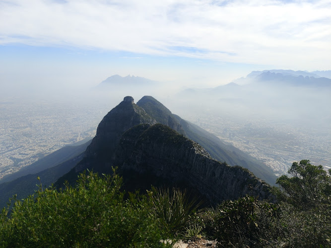
Al Pico Perico is one of those places that quietly sneaks up on you — not in a dramatic, postcard-perfect way, but in that slow, grounding sort of way that makes you realize how much you needed to step outside your daily routine.
Highlights & Key Features
Scenic hiking trails with panoramic mountain views
Dog-friendly environment — perfect for hikers with pets
Kid-friendly routes suitable for family outings
Natural, unspoiled terrain ideal for outdoor enthusiasts
Peaceful atmosphere away from city noise
Moderate climb offering a satisfying challenge without being extreme
Ideal spot for photography, sunrise hikes, and quiet reflection
Visitor Guide & Information
Description
For anyone who loves hiking, this spot feels like a hidden gem. The climb can be challenging in parts — not impossible, but enough to make you feel like you’ve earned the view at the top. And that view? It’s the kind that makes you pause for a few minutes, just to breathe and take it all in. You can see the outlines of the city far below, framed by layers of green and gray mountains. There’s something grounding about standing there, wind in your face, realizing how small and connected we all are to this land.
It’s worth noting that Al Pico Perico isn’t a polished tourist attraction with paved paths or fancy facilities. It’s more of a “bring your own sense of adventure” kind of place. You’ll want sturdy shoes, plenty of water, and a willingness to get a little dusty. But that’s what makes it special — it still feels wild, like nature hasn’t been tamed here. Families often come for a weekend hike, and dog owners love that pets are welcome. You might even see a few kids scrambling up the rocks, laughing and pretending they’re on some great expedition.
Of course, not every visitor falls head over heels for it. Some find the trail tougher than expected or wish there were more facilities. But most people walk away with a smile, grateful for the peace and the perspective that comes from being surrounded by mountains. Personally, I think that’s what travel should be about — not just the places that look good in photos, but the ones that make you feel something real.
Best Time to Visit
If you’re planning a trip to Al Pico Perico, timing makes a big difference. The best months to visit are between October and March, when the weather is cooler and the air feels crisp. Summer can be brutally hot in this region, and the sun doesn’t take prisoners — trust me, I tried hiking here one July afternoon and ended up regretting my life choices halfway up. The cooler months, though, are perfect. You’ll get clear skies, comfortable temperatures, and that golden morning light that makes everything look a bit magical.
Early mornings are hands down the best time of day to start. Not only do you avoid the midday heat, but you also get to hear the forest waking up — birds calling, leaves rustling, the soft hum of life around you. Sunset hikes are beautiful too, though you’ll want to bring a flashlight for the way down. And if you’re a photographer, those twilight hours are pure gold. The light hits the mountains just right, painting them in shades of orange and pink that no filter could ever replicate.
How to Get There
Reaching Al Pico Perico isn’t complicated, but it does require a bit of planning. Most travelers start from Monterrey, which is the nearest major city. From there, it’s a relatively short drive toward the outskirts, where the roads start winding through the foothills. The final stretch is a mix of paved and dirt roads, so if you’re driving, a vehicle with decent ground clearance will make your life easier.
There’s no massive parking lot or big sign announcing your arrival — it’s more understated than that. You’ll likely see other hikers’ cars parked along the roadside, and that’s usually your cue that you’re in the right spot. Public transportation doesn’t really reach this area, so carpooling or taking a taxi from the city is your best bet if you don’t have your own wheels.
Once you’re there, the trailhead is easy enough to find. It starts off gently, winding through low brush before gradually climbing into steeper terrain. The path is mostly dirt and rock, with a few shaded sections that feel like a blessing on warmer days. And while there aren’t any official guides or markers, the route is fairly intuitive — just follow the trail and the sound of your own curiosity.
Tips for Visiting
Before heading out, a few tips can make your visit smoother and more enjoyable. First, bring more water than you think you’ll need. The climb isn’t overly long, but the dry air and sun can dehydrate you fast. A hat, sunscreen, and a few snacks go a long way too. I usually pack a couple of granola bars and some fruit — simple, light, and perfect for a quick break halfway up.
Second, go early. Not just for the cooler temperatures, but because mornings tend to be quieter. There’s something almost meditative about walking the trail when it’s just you and the sound of your footsteps. Later in the day, especially on weekends, it can get busier with families and groups.
If you’re bringing your dog, keep a leash handy. Most people are respectful, but it’s always better to be cautious, especially if you run into other hikers or wildlife. Speaking of wildlife, you might spot small lizards, birds, or even the occasional rabbit darting across the path. Nothing dangerous, just the usual mountain locals going about their day.
Footwear is another big one. Regular sneakers might do for the lower sections, but hiking boots or shoes with good grip are much better for the rocky parts. I’ve seen people try to tackle it in sandals — trust me, that’s a mistake you only make once.
Lastly, don’t rush it. The real reward of Al Pico Perico isn’t just reaching the top; it’s the journey itself. Take breaks, enjoy the views, and maybe even sit down for a few minutes to just listen. It’s easy to get caught up in the idea of “getting there,” but sometimes the best moments happen when you slow down.
For photographers, bring a lightweight tripod if you can. The lighting conditions can change quickly, and you’ll want to capture that soft, shifting glow over the mountains. And for those who love a bit of solitude, weekdays are your best friend — fewer people, more peace.
In the end, Al Pico Perico is the kind of place that rewards curiosity and patience. It’s not about luxury or convenience; it’s about connection — with nature, with yourself, and with the world around you. Whether you’re a seasoned hiker or just someone looking for a quiet escape from city life, it has a way of reminding you what really matters. And that, honestly, is worth every step of the climb.
Al Pico Perico is one of those places that quietly sneaks up on you — not in a dramatic, postcard-perfect way, but in that slow, grounding sort of way that makes you realize how much you needed to step outside your daily routine. Tucked away in the rugged hills near Monterrey, this natural preserve offers a raw, unfiltered slice of northern Mexico’s beauty. It’s not overly commercialized, and that’s part of its charm. The trails wind through rocky paths and forested slopes, with sweeping views that seem to stretch forever. You’ll hear birds, the crunch of gravel under your boots, and maybe the occasional bark from a happy dog trotting ahead of its human.
For anyone who loves hiking, this spot feels like a hidden gem. The climb can be challenging in parts — not impossible, but enough to make you feel like you’ve earned the view at the top. And that view? It’s the kind that makes you pause for a few minutes, just to breathe and take it all in. You can see the outlines of the city far below, framed by layers of green and gray mountains. There’s something grounding about standing there, wind in your face, realizing how small and connected we all are to this land.
It’s worth noting that Al Pico Perico isn’t a polished tourist attraction with paved paths or fancy facilities. It’s more of a “bring your own sense of adventure” kind of place. You’ll want sturdy shoes, plenty of water, and a willingness to get a little dusty. But that’s what makes it special — it still feels wild, like nature hasn’t been tamed here. Families often come for a weekend hike, and dog owners love that pets are welcome. You might even see a few kids scrambling up the rocks, laughing and pretending they’re on some great expedition.
Of course, not every visitor falls head over heels for it. Some find the trail tougher than expected or wish there were more facilities. But most people walk away with a smile, grateful for the peace and the perspective that comes from being surrounded by mountains. Personally, I think that’s what travel should be about — not just the places that look good in photos, but the ones that make you feel something real.
Key Features
Scenic hiking trails with panoramic mountain views
Dog-friendly environment — perfect for hikers with pets
Kid-friendly routes suitable for family outings
Natural, unspoiled terrain ideal for outdoor enthusiasts
Peaceful atmosphere away from city noise
Moderate climb offering a satisfying challenge without being extreme
Ideal spot for photography, sunrise hikes, and quiet reflection
Best Time to Visit
If you’re planning a trip to Al Pico Perico, timing makes a big difference. The best months to visit are between October and March, when the weather is cooler and the air feels crisp. Summer can be brutally hot in this region, and the sun doesn’t take prisoners — trust me, I tried hiking here one July afternoon and ended up regretting my life choices halfway up. The cooler months, though, are perfect. You’ll get clear skies, comfortable temperatures, and that golden morning light that makes everything look a bit magical.
Early mornings are hands down the best time of day to start. Not only do you avoid the midday heat, but you also get to hear the forest waking up — birds calling, leaves rustling, the soft hum of life around you. Sunset hikes are beautiful too, though you’ll want to bring a flashlight for the way down. And if you’re a photographer, those twilight hours are pure gold. The light hits the mountains just right, painting them in shades of orange and pink that no filter could ever replicate.
How to Get There
Reaching Al Pico Perico isn’t complicated, but it does require a bit of planning. Most travelers start from Monterrey, which is the nearest major city. From there, it’s a relatively short drive toward the outskirts, where the roads start winding through the foothills. The final stretch is a mix of paved and dirt roads, so if you’re driving, a vehicle with decent ground clearance will make your life easier.
There’s no massive parking lot or big sign announcing your arrival — it’s more understated than that. You’ll likely see other hikers’ cars parked along the roadside, and that’s usually your cue that you’re in the right spot. Public transportation doesn’t really reach this area, so carpooling or taking a taxi from the city is your best bet if you don’t have your own wheels.
Once you’re there, the trailhead is easy enough to find. It starts off gently, winding through low brush before gradually climbing into steeper terrain. The path is mostly dirt and rock, with a few shaded sections that feel like a blessing on warmer days. And while there aren’t any official guides or markers, the route is fairly intuitive — just follow the trail and the sound of your own curiosity.
Tips for Visiting
Before heading out, a few tips can make your visit smoother and more enjoyable. First, bring more water than you think you’ll need. The climb isn’t overly long, but the dry air and sun can dehydrate you fast. A hat, sunscreen, and a few snacks go a long way too. I usually pack a couple of granola bars and some fruit — simple, light, and perfect for a quick break halfway up.
Second, go early. Not just for the cooler temperatures, but because mornings tend to be quieter. There’s something almost meditative about walking the trail when it’s just you and the sound of your footsteps. Later in the day, especially on weekends, it can get busier with families and groups.
If you’re bringing your dog, keep a leash handy. Most people are respectful, but it’s always better to be cautious, especially if you run into other hikers or wildlife. Speaking of wildlife, you might spot small lizards, birds, or even the occasional rabbit darting across the path. Nothing dangerous, just the usual mountain locals going about their day.
Footwear is another big one. Regular sneakers might do for the lower sections, but hiking boots or shoes with good grip are much better for the rocky parts. I’ve seen people try to tackle it in sandals — trust me, that’s a mistake you only make once.
Lastly, don’t rush it. The real reward of Al Pico Perico isn’t just reaching the top; it’s the journey itself. Take breaks, enjoy the views, and maybe even sit down for a few minutes to just listen. It’s easy to get caught up in the idea of “getting there,” but sometimes the best moments happen when you slow down.
For photographers, bring a lightweight tripod if you can. The lighting conditions can change quickly, and you’ll want to capture that soft, shifting glow over the mountains. And for those who love a bit of solitude, weekdays are your best friend — fewer people, more peace.
In the end, Al Pico Perico is the kind of place that rewards curiosity and patience. It’s not about luxury or convenience; it’s about connection — with nature, with yourself, and with the world around you. Whether you’re a seasoned hiker or just someone looking for a quiet escape from city life, it has a way of reminding you what really matters. And that, honestly, is worth every step of the climb.
Key Highlights
Scenic hiking trails with panoramic mountain views
Dog-friendly environment — perfect for hikers with pets
Kid-friendly routes suitable for family outings
Natural, unspoiled terrain ideal for outdoor enthusiasts
Peaceful atmosphere away from city noise
Moderate climb offering a satisfying challenge without being extreme
Ideal spot for photography, sunrise hikes, and quiet reflection
Pico Perico, Monterrey: A Practical Hiking Guide to One of Las Mitras’ Signature Peaks
Pico Perico (“Parrot Peak”) is a standout summit on Cerro de las Mitras, the saw-toothed ridgeline that frames Monterrey’s skyline. Expect a demanding hike with sections of steep scree, short cave passages, chains, and light scrambling—rewarded by sweeping views over Monterrey, San Pedro Garza García, and the surrounding canyons. The route is inside the Reserva Natural Estatal Sierra de las Mitras; plan for a full day, start early, and treat it like an alpine objective rather than a city stroll.SummitPost
Quick Facts (for planning)
Location: Sierra de las Mitras, Monterrey metro (Nuevo León, Mexico). Common approaches leave from Colonia Cumbres / Calle Venecia on the city’s west side.
Coordinates (peak area): around 25.711° N, −100.420° W.PeakVisor App
Elevation: sources list ~1,980–1,995 m above sea level; it’s among the higher Mitras summits.gaiaxtreme.com
Typical time on trail: 5–7 hours round trip for strong hikers, depending on route and conditions.
Park/Reserve: Reserva Natural Estatal Sierra de las Mitras (state natural reserve).
Best season: Year-round, but avoid midday heat; winter fronts can bring wind and chill on the ridge. (Conditions vary day-to-day—check latest community reports.)wanderlog.com
Why Pico Perico is Different
Most city-proximate hikes don’t mix trail, mine heritage, cave features, chains, and via ferrata-style moves. Pico Perico does. Expect:
Varied terrain: oak woodland, a long “stone river” (loose rock gully), narrow ledges, and short cave/abandoned-mine segments near the upper traverse.Mountain Forecast
Hands-on sections: fixed chains and brief scrambles that reward good footwork and gloves; helmets are widely recommended by local hikers for rockfall mitigation in the gullies.wanderlog.com
A direct skyline viewpoint: the summit outlook faces Monterrey’s urban basin and neighboring peaks across the Mitras massif.Reddit
This blend makes Pico Perico one of the most climbed and most recognizable Las Mitras summits—often cited as the second-highest peak on the ridge.SummitPost
Route Overview (Cumbres / Calle Venecia approach)
There are several variations to Pico Perico; the outline below reflects common, well-documented lines used by local hikers. Conditions and signage change—treat this as a planning summary and verify specific waypoints with up-to-date GPX and local advisories.
Trailhead – Calle Venecia (Cumbres): From the west-side neighborhoods below Las Mitras, hikers gain the marked path; look for colored ribbons in the lower forest.
Steep ascent through oak forest → “stone river”: A steady, steep climb transitions into a boulder/scree gully. Trekking poles help on the ascent; on descent, keep spacing to reduce rockfall risk.Mountain Forecast
Horizontal traverse & mine relics: A contouring section crosses old mine remains; carry a headlamp if you plan to peek inside (entering mine adits is inherently risky—assess hazards conservatively).Mountain Forecast
Cave/“chorreadero” segments and chains: Near upper junctions, expect short cave-like passages and fixed chains; gloves improve grip. Route-finding can branch toward features like “Las Cadenas” before the final ramp to the summit.Wikiloc | Rutas del Mundo
Summit ridge: Exposed in places, especially in wind. Views extend over Monterrey, San Pedro, and the Santa Catarina corridor.Reddit
Time & distance: Community datasets report ~9–12 km round trip and 5–7 hours, depending on variant and pace. Technical guiding companies market it as a “fun and challenging” full-day outing at ~1,980 m summit elevation.La Cumbre Cotidiana
Difficulty, Risks & Required Fitness
Rating: Generally challenging due to steep gain, loose footing, basic scrambling, and short protected moves. Not suitable as a first hike for beginners.
Objective hazards: Rockfall in gullies; slippery limestone when wet; exposure in short sections; heat stress on clear days; route-finding errors at branch points.wanderlog.com
Suggested skills/gear:
Solid mountain fitness; comfort with hands-on terrain.
Helmet, gloves, and proper footwear (aggressive tread).
Headlamp (mine/cave segments), 2–3 L water minimum, sun protection, layers for ridge wind.wanderlog.com
Inclusivity & access note: Fitness, experience, and gear vary widely. There’s no shame in turning around at your comfort threshold—Pico Perico has meaningful hazards and is best undertaken with partners who match your pace and experience. (Local groups often share recent condition updates.)facebook.com
Navigation & Starting Points
Common start: Calle Venecia (Cumbres sector). Community GPX lines and recent trip reports reference this access repeatedly.
Map pins you’ll see online: “Al Pico Perico” and Cima del Bosque are frequently used address tags by mapping apps; they refer to the built-up neighborhoods below the mountain, not the summit itself. Always navigate by a trail GPX, not by a generic POI name. Singapore
Approx. summit coordinates: 25.711079 N, −100.420228 W (reference only; your GPX line should govern on-trail choices).PeakVisor App
Responsible Hiking in Sierra de las Mitras (What Locals Wish Visitors Knew)
Start early; finish early. Heat and afternoon weather roll in fast; the ridge is exposed.
Group spacing in the gully. Manage rockfall risk by keeping distance and communicating. Helmets reduce risk from small debris.wanderlog.com
Respect closures and signage. It’s a state reserve with sensitive limestone habitat and legacy mine areas. Stay on established paths and avoid entering unstable shafts.Mountain Forecast
Pack-in/pack-out. No services on route; carry all water and take all trash out. (Several operators offer guided days if you prefer structured logistics.)aventureros.com.mx
Alternatives & Add-Ons Nearby
If you like Pico Perico’s style but want to scale difficulty up or down, the Las Mitras chain offers other classic summits (e.g., Pico Piquín, Pico Alfa, Pico Cuauhtémoc). Many share steep limestone, big city views, and a mix of social paths and scrambles. Verify current conditions and GPX lines before you go.Wikiloc | Rutas del Mundo
Getting There (City Context)
Pico Perico rises immediately above Monterrey’s western neighborhoods; that proximity makes rideshares or short drives to the Cumbres trailheads practical when starting before sunrise. Some mapping apps list “Al pico perico” as a 24/7 attraction pin, but there’s no gate with official hours—you’re entering a natural reserve via neighborhood access points. Be discreet, respect residents, and avoid blocking driveways.
What’s Currently Uncertain or Varies (Flagging Potentially Outdated Data)
Exact elevation figure: You’ll see ~1,980–1,995 m across reputable sources; expect minor discrepancies due to datasets and peak definitions.gaiaxtreme.com
On-trail infrastructure: Chains, markers, and informal signage change over time as volunteers and groups maintain routes. Treat prior reports as indicative, not guaranteed, and verify with recent GPX and local updates before committing to exposed segments.wanderlog.com
Final Call
If you want a full-value Monterrey mountain day with hands-on terrain and city-to-summit drama, Pico Perico is exactly that—challenging, scenic, and technical enough to be memorable. Go prepared, carry a reliable GPX, and use conservative judgment on the upper sections. You’ll earn the view.
Sources used in this guide include community trail databases, planning reports, and reserve references for Pico Perico and Sierra de las Mitras (access, difficulty, and route character). Where figures differed, ranges are provided to reflect variability.
Explore verified points of interest within walking or short transit distance.
No neighboring places mapped within 5 km yet.
Find Places to Stay Nearby
Stay22 provides this accommodation search. We may earn a commission if you book through it; verify current prices and terms with the provider.
🗺️
Interactive accommodation map requires marketing cookies to display live rates.
Recommended Experiences & Activities
GetYourGuide provides this tour inventory. We may earn a commission if you book through it; verify current availability, prices, and terms with the provider.
Top Viator Experiences & Guided Tours in Monterrey
We may earn a commission if you book through links on this page at no extra cost to you. All tours feature verified customer reviews and flexible cancellation options.