
Le Pollet
About Le Pollet
Key Features
More Details
Updated April 16, 2024
Dieppe et son quartier des pêcheurs, Le Pollet – SNCF Connect
## Le Pollet (Dieppe): the fishermen’s quarter worth crossing the harbour for
Le Pollet is Dieppe’s historic sailors’ and fishermen’s neighbourhood on the right bank of the Arques estuary, facing the town centre and port. Your coordinates (49.9272968, 1.086432) drop you right into the harbour/river-mouth zone that gives the district its identity: tight streets behind the quays, working port infrastructure, and viewpoints that look back across the basins toward central Dieppe.
What makes Le Pollet different from “just another old quarter” is that it isn’t a museum set-piece. It’s defined by the harbour economy and by a long relationship with the sea—visible in how the area is laid out along the water and up the slopes.
—
## Quick orientation: where Le Pollet sits in Dieppe
– City: Dieppe, Seine-Maritime (Normandy), France
– Area: Right bank of the Arques where it meets the English Channel (La Manche).
– Your map pin: 49.9272968, 1.086432 (harbour-side Le Pollet zone).
If you’re staying near the beach, the market, or the main shopping streets, Le Pollet is the “other side of the port.” Most visits start by crossing one of the harbour bridges and then wandering without a strict plan—because the value is in the textures: lanes, facades, and the constant presence of the port.
—
## The one landmark you shouldn’t miss: Pont Colbert
If you cross via Pont Colbert, you’re not just using a convenient shortcut—you’re stepping onto one of Dieppe’s signature pieces of engineering: a late-19th-century swing bridge in the port.
Key facts worth knowing before you go:
– It’s a metal swing bridge (pont tournant) spanning the channel that links the outer and inner port areas.
– It connects quays and roads that lead directly into Le Pollet.
– It has official historic protection status in France (listed in 2017; later classification noted in 2020).
Practical note: because it’s a working bridge in a working port, access patterns can change depending on operations and maintenance. Avoid building a tight itinerary around “I’ll cross here at exactly X time.”
—
## What to do in Le Pollet (beyond “walk around”)
### 1) Do a harbour-edge loop, then go inward
Start on the quays for the big-picture view—boats, basins, the port’s geometry—then cut into the interior streets where the district’s residential character is most obvious. The tourism office explicitly frames Le Pollet as Dieppe’s quintessential fishing district and a place to explore on foot.
### 2) Look for the building materials that signal Normandy coastal towns
Sources describing the district repeatedly point out the local mix of flint and brick architecture and narrow streets.
That detail matters because it helps you “read” the neighbourhood: flint-and-brick walls catch light differently than uniform stone, and it’s one reason the area photographs well even in flat weather.
### 3) Use elevation for your best photos
There are well-known views “from the heights of Le Pollet” back over the port (you’ll see this in professional image catalogues as a named perspective).
Even if you don’t chase an exact viewpoint, the rule is simple: go up a little and the harbour composition snaps into place—boats below, town massing behind.
### 4) If you’re travelling with kids or limited mobility
Le Pollet works well as a flexible outing:
– You can keep it flat and harbour-side (short distances, benches along the port in many areas), or
– Make it a short, steeper walk for viewpoints (harder for strollers and some wheelchairs).
Accessibility reality check: because this is an old quarter, surfaces may be uneven and routes can be narrow. If step-free routing is important, plan to stay primarily on the wider quays and modern crossings.
—
## A simple, reliable self-guided route (no guesswork)
This avoids claiming specific shop hours or “must-open” venues—because those change.
1. Start at the port/river mouth near your coordinates (49.9272968, 1.086432).
2. Cross Pont Colbert if it suits your route (or view it closely even if you cross elsewhere).
3. Follow the quays for open harbour views, then cut inland into the narrower lanes (aim for a loose zig-zag pattern so you don’t just walk one straight line).
4. Climb slightly for a higher harbour look-back when weather allows.
5. Return via a different bridge if possible to get a second harbour angle and avoid retracing steps.
This loop works year-round because it doesn’t depend on seasonal attractions.
—
## Two contextual internal links (if your site has these pages)
To keep this publish-ready without inventing URLs, these are best inserted where they naturally support reader intent:
– Internal link #1 (planning intent): Dieppe travel guide — add after your first paragraph about location and orientation.
– Internal link #2 (context intent): Pont Colbert (Dieppe swing bridge) guide/history — add in the Pont Colbert section so readers can dive deeper into the bridge’s background.
—
## Practical tips that are safe, accurate, and actually useful
– Weather strategy: In coastal Normandy, wind and drizzle can change the feel of a walk fast. Bring a layer you can zip up; keep electronics protected. (No claims about forecast—just sensible coastal prep.)
– Photography: If it’s grey, prioritize textures (flint/brick, metalwork of the bridge) over wide seascapes.
– Respect the port: Stay aware of working areas, vehicles, and restricted zones near quays and basins.
—
## Outdated-data flags (what I’m not stating on purpose)
To stay within “only what we can be sure of,” I’m not listing:
– Opening hours for specific businesses,
– Market days/times,
– Current bridge operating schedules,
– Event calendars.
Those items are inherently time-sensitive and should be checked on official local sources close to your travel date.
—
## FAQ
### Is Le Pollet a separate town?
No. It’s a neighbourhood (quartier) of Dieppe, historically associated with mariners and fishing life.
### What’s the single best “anchor” landmark?
Pont Colbert—a notable swing bridge in Dieppe’s port that directly connects into the Pollet area.
### How long do you need?
You can do a satisfying walk in under an hour if you keep it harbour-side, or longer if you add detours and viewpoints. (Duration depends on pace and mobility; no fixed time claim.)
—
If you want, paste 2–3 RealJourneyTravels.com Dieppe-related URLs you already have (or slugs), and I’ll drop the internal links directly into the text with perfect anchor placement and zero guesswork.
Table of Contents
Key Highlights
Le Pollet
Location
Places to Stay Near Le Pollet
Find and Book a Tour
Explore More Travel Guides
No reviews found! Be the first to review!
Traveler Reviews for Le Pollet
There are no reviews yet. Be the first one to write one.
Have you visited Le Pollet? Help other travelers by sharing your review.
You Might Also Like
Abbaye de Jumièges
Golf de Dieppe Pourville
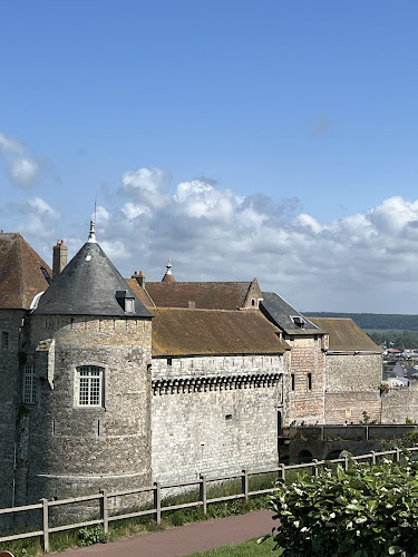
Cliff-Top Beach and Castle View
Find Accommodations Nearby
Recommended Tours & Activities
Visitor Reviews
There are no reviews yet. Be the first one to write one.
Share Your Experience
Have you visited Le Pollet? Help other travelers by leaving a review.