
Jambatan Muar Johor
About Jambatan Muar Johor
Key Features
More Details
Updated June 11, 2025
Jambatan Muar Johor – All You Need to Know BEFORE You Go
## Jambatan Muar Johor (Sultan Ismail Bridge): What to Know Before You Walk or Drive It
Jambatan Muar Johor is widely referenced online as Sultan Ismail Bridge (Malay: Jambatan Sultan Ismail), a road bridge crossing the Muar River in Muar, Johor, Malaysia. It’s positioned on Jalan Kesang and functions as a key crossing between Bandar Maharani (Muar town) and Tanjung Agas (now within Tangkak district).
If you’re the kind of traveler who likes “small city, real life” infrastructure landmarks—bridges that locals actually use—this one is worth a stop, especially for river views and the recognizable gateway signage at the Muar side.
### Quick facts (verified)
– Official / common name: Sultan Ismail Bridge (Jambatan Sultan Ismail)
– Location: Jalan Kesang, 84000 Muar, Johor, Malaysia Singapore
– Crosses: Muar River
– Carries: Motor vehicles and pedestrians
– Length / width (reported): ~385 m long, ~9 m wide
– Opened (reported): 1967
– Coordinates provided: 2.0495702, 102.5681746
## What you’re actually seeing on-site
This is not a “tourist bridge” built for photos first. It’s a functioning town crossing with a long, straight run over the river and consistent sightlines—great for understanding Muar’s geography in about five minutes.
### The Muar-side gateway and why it matters
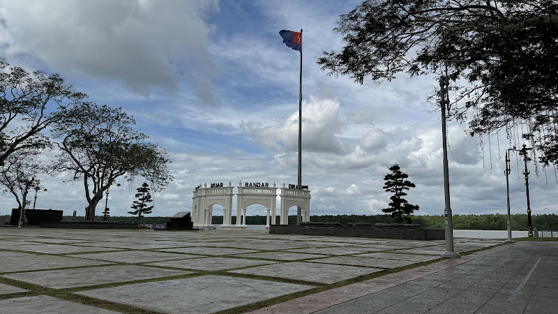
Many photos of “Jambatan Muar Johor” focus on a large arch/gateway structure at one end of the bridge. That visual marker is part of why the bridge gets pinned, reviewed, and remembered compared with thousands of other utilitarian crossings.
### River-view payoff (without needing a boat)
From the bridge you get open views along the Muar River toward the river mouth direction (the bridge is described as near the mouth of the river). If you’re building context for a Muar day—markets, coffee, heritage blocks—this is a fast “orientation point.”
## How to visit without getting in the way
Because this is active infrastructure, the main rule is simple: treat it like a road first, viewpoint second.
### Best way to experience it
– Walk a short section rather than committing to a full crossing if traffic feels fast where you enter. The bridge is documented as carrying pedestrians, but it remains primarily a vehicular route.
– If you’re driving, use your stop for photos from safe areas near the ends of the bridge rather than pulling over on the span.
### When to go
I can’t verify official “best times” (that’s subjective), but from publicly available photos you can see the bridge is fully exposed with limited shade—so heat and glare are practical considerations.
## What’s nearby (only what can be verified)
A few sources explicitly connect the bridge with nearby areas/landmarks:
– Tanjung Agas is directly associated with the crossing (the bridge connects Muar/Bandar Maharani to Tanjung Agas).
– A second bridge/bypass solution was built later to address congestion, with construction and opening timelines reported in reference summaries.
If you’re planning your route, that “two bridges + bypass” reality matters: it affects whether this bridge feels calm enough for a walk at the time you arrive.
## History notes that are safe to repeat
The bridge is repeatedly described as replacing older ferry services across the Muar River in the 1960s, and it is reported to have once been a toll bridge before tolls were later abolished.
That history is why locals may refer to this crossing with extra weight: it wasn’t just another road project—it materially changed how Muar connected with the opposite bank and onward routes.
## Practical traveler tips (factual + low-risk)
### Safety and comfort
– Expect sun exposure: the span is open and the surface is hardscape.
– If you’re walking, stay alert for motor traffic at all times; this is a live route that carries vehicles.
### Photography
– The most recognizable “I was here” frame is the gateway/arch at the bridge end.
– For river shots, photos taken along the railing show the long, low profile and waterline view.
## Outdated-data flags (read this before you rely on listings)
A few travel platforms present the bridge like a ticketed attraction with “opening hours” fields. Singapore Because this is documented as a public bridge carrying road traffic, those “ticket/hours” entries can be template-driven rather than based on an official visitor operation.
What to do instead:
– Treat any “ticket” or “opening hours” field you see on booking sites as non-authoritative unless it’s backed by an official road authority notice. Singapore
– If you’re visiting during an event period, verify locally—bridges can be temporarily closed for crowd or civic events (closures have been reported historically).
## Who this stop is best for
– Urban and small-city explorers who like understanding how a place works, not just what it advertises.
– Photographers who want a clean structural line, water reflections, and a strong “gateway” subject without needing a paid viewpoint.
– Route-planners moving between Muar and the opposite bank who want a quick landmark pause (not a detour).
## Summary: why Jambatan Muar Johor is worth 20 minutes
Sultan Ismail Bridge (Jambatan Muar Johor) is a straightforward landmark: a historically significant crossing over the Muar River, on Jalan Kesang, linking Muar’s core (Bandar Maharani) with Tanjung Agas. It’s not “decorative,” but it is memorable—especially at the gateway end—and it gives you a fast, honest read on Muar’s river geography.
Key Highlights
Jambatan Muar Johor
Location
Places to Stay Near Jambatan Muar Johor"Attractions: Along the Muar side, there's the beautiful archway, and ..."
Find and Book a Tour
Explore More Travel Guides
No reviews found! Be the first to review!
Traveler Reviews for Jambatan Muar Johor
There are no reviews yet. Be the first one to write one.
Have you visited Jambatan Muar Johor? Help other travelers by sharing your review.
You Might Also Like
Donhu Jurassic Garden
Tanjung Emas Park
Beca Gergasi Muar
Find Accommodations Nearby
Recommended Tours & Activities
Visitor Reviews
There are no reviews yet. Be the first one to write one.
Share Your Experience
Have you visited Jambatan Muar Johor? Help other travelers by leaving a review.