
Diamond Peak
About Diamond Peak
Key Features
More Details
Updated April 15, 2024
Pico do Diamante (Pindamonhangaba) – ATUALIZADO 2023 O que saber antes …
## Diamond Peak (Pico do Diamante): what it is and where it sits
“Diamond Peak” in Pindamonhangaba, São Paulo, is commonly referenced online as Pico do Diamante, a mountain/viewpoint in Brazil’s Mantiqueira Mountains (Serra da Mantiqueira). App
Quick facts (verifiable):
– Location: Pindamonhangaba, State of São Paulo, Brazil App
– Coordinates (approx.): around 22.791° S, 45.570° W (sources vary slightly) App
– Elevation: listed as 1,952 m (6,404 ft) by PeakVisor App
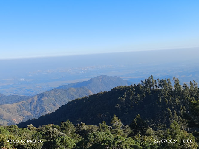
– What it’s known for: panoramic views; visitors mention sunrise/sunset and big-sky viewpoints
## Why it’s worth the detour
Pico do Diamante is the kind of place you visit for one main reason: a wide, open ridgeline view. Multiple visitor write-ups emphasize the scenery and the “vista” as the payoff, rather than facilities or built attractions.
If you’re building a São Paulo-state itinerary that isn’t just city-to-city, this is a strong candidate for a high-elevation nature stop in the Paraíba Valley/Mantiqueira region. App
## Getting there
### Access reality check (road + approach)
Public write-ups repeatedly highlight access difficulty for low-clearance cars, with steep sections, holes/rocks, and narrow stretches—basically: road conditions can be the limiting factor, not your fitness.
Some route descriptions also frame the peak as being in Pindamonhangaba territory while commonly approached via Campos do Jordão access roads (how many people actually reach the start). MTB
Practical implication: If you’re not in a suitable vehicle (or you’re unsure about current conditions), plan to reach the area with local transport/4×4 support rather than forcing a standard city car up a rough final approach.
## Hiking options (what the trail data actually says)
Because different platforms host different tracks, you’ll see different “official” numbers depending on which GPX someone recorded.
### A moderate recorded route (Wikiloc example)
One published hiking track labeled “Pico do Diamante – Pindamonhangaba (Campos do Jordão)” lists:
– Distance: 5.18 km (3.22 mi)
– Elevation gain: 205 m (673 ft)
– Max elevation on that track: 1,873 m (6,145 ft)
– Difficulty: Moderate
– Type: One way | Trails of the World
Wikiloc’s itinerary description also explicitly frames it as a climb to “Pico do Diamante (1900m)”. | Trails of the World
### A longer hard hike (AllTrails listing snippet)
AllTrails’ listing for Campos de Jordão – Raizera – Pico do Diamante describes it as:
– 11.1 miles with 2,181 ft elevation gain, typically 5.5–6.5 hours
How to use this without guessing: Treat these as route-specific stats, not the mountain’s absolute truth. Your numbers will depend on where you start, whether you’re doing out-and-back, and which access road/trailhead you use. | Trails of the World
## What to bring (based on what the place is)
These are not “nice-to-haves” at exposed peaks—this is basic risk control for wind, sun, and uneven terrain:
– Layering for wind chill: peaks can feel much colder than the city below; visitors specifically mention cold and strong wind at the top during sunrise trips.
– Sun protection: high UV exposure is typical on open summits (hat, sunscreen, sunglasses).
– Water + snacks: at least enough for your planned route duration; this is not a facility-heavy attraction (and at least one visitor review warns there are no restaurants/attractions up top).
– Footwear with grip: uneven ground and steep sections are common in recorded trails. | Trails of the World
– Offline navigation: if you’re relying on GPX tracks, download them before you lose signal.
## Timing: sunrise, sunset, and visibility
The most consistently mentioned “best moments” are sunrise and sunset, largely because the viewpoint is open and expansive.
Visibility tip (factual, not predictive): Mountain viewpoints can be crystal-clear or completely clouded-in on the same day; plan your schedule so you still enjoy the journey even if the summit view doesn’t cooperate.
## Etiquette and safety (especially for shared viewpoints)
A public viewpoint works only if visitors treat it like shared space:
– Keep sound low (portable speakers change the experience for everyone).
– Pack out everything you bring in.
– Avoid fire risk: if a location is dry/windy, flames can escalate fast; follow local rules and signage.
## Ratings and “outdated data” flags
– Your dataset lists 4.8 for Diamond Peak, but public pages can show different ratings (e.g., Tripadvisor’s Pico do Diamante page displays 4.5 based on a small review count at the time captured in search results). Ratings are time-sensitive and can shift with new reviews.
– Trail stats also vary by source and track (Wikiloc’s max elevation on one route vs. PeakVisor’s elevation for the summit). Use these as directional guidance, not absolute measurements. App
## Snapshot for your CMS fields
– Name: Diamond Peak / Pico do Diamante App
– City: Pindamonhangaba (São Paulo, Brazil) App
– Coordinates: -22.7915145, -45.5711702 (dataset) and close matches around -22.791061, -45.570504 (reference source) App
– Type: Tourist attraction / mountain viewpoint App
Table of Contents
Key Highlights
Diamond Peak
Location
Places to Stay Near Diamond Peak
Find and Book a Tour
Explore More Travel Guides
No reviews found! Be the first to review!
Traveler Reviews for Diamond Peak
There are no reviews yet. Be the first one to write one.
Have you visited Diamond Peak? Help other travelers by sharing your review.
You Might Also Like
Cachoeira Véu da Noiva
Cachoeira do índio
Itapeva Park
Find Accommodations Nearby
Recommended Tours & Activities
Visitor Reviews
There are no reviews yet. Be the first one to write one.
Share Your Experience
Have you visited Diamond Peak? Help other travelers by leaving a review.