Chaine de l
About Chaine de l
Key Features
More Details
Updated June 11, 2025
Timelapse Kpalime (Chaine de l’Atakora) – YouTube
## Chaine de l’Atakora from Kpalimé, Togo: Mountains, Waterfalls & Culture in the Plateaux Region
If you’re looking at Kpalimé on the map and wondering what “Chaine de l’Atakora” actually means for your trip, you’re essentially looking at the western spine of Togo – the low mountain range that frames the city with hills, forests, and waterfalls.
Use the quick jumps if you’re planning an itinerary:
– Kpalimé as your gateway town
– Practical tips for visiting the Atakora range
—
## What is the Chaine de l’Atakora?
Geographically, the Chaîne de l’Atakora (often spelled Atacora or Atakora) is a mountain chain that runs north-east / south-west from the Akwapim Hills in Ghana, across Togo, into north-west Benin and on toward the Niger River.
In Togo, this same structure is often called the Togo Mountains. A political–geography overview of Togo notes that a low mountain range cuts across the center of the country and continues along the border with Ghana to the Kpalimé area in the southwest, forming a plateau of roughly 400–800 m with hills that can reach around 700 m in height.
Key points, grounded in current sources:
– The Atakora/Togo Mountains form a continuous chain from near Accra (Ghana) into Togo and Benin.
– Near Kpalimé, the range becomes a cooler, hilly plateau – part of Togo’s Plateaux Region.
– Geologically, the chain is made of sandstones, mica schists and quartzites, with conditions suitable for agriculture on the upland plateau.
From a traveller perspective, when you see “Chaine de l’Atakora – Kpalimé,” you’re really talking about the mountain landscapes and foothills surrounding Kpalimé: ridges, forested slopes, and a cluster of individual peaks and plateaux that all belong to this wider Atakora system.
—
## Kpalimé: Your Gateway Town
Kpalimé is a city in Togo’s Plateaux Region, about 120 km north of Lomé and roughly 15 km from the Ghanaian border. It’s the administrative capital of Kloto Prefecture and one of Togo’s largest towns.
A few verified facts that matter for planning:
– Population & role – Around 75,000 people (2010 census), making it Togo’s fourth-largest town after Lomé, Sokodé, and Kara.
– Services – The town has a cathedral, secondary schools, medical centres, pharmacies, banks, petrol stations and cyber-cafés, so you can treat it as a proper staging point rather than a tiny village.
– Craft centre – Kpalimé is a national hub for crafts: wood sculpture, weaving, wickerwork, batik, ceramics, and mounted butterflies, with dozens of artisanal workshops and training facilities.
### Language & communication
For visitors, two language facts are important:
– French is the official and administrative language of Togo.
– Ewe is the main local and lingua franca language in Kpalimé and across much of southern Togo.
Any planning around guides, signage, or community projects should assume French + Ewe dominate, with English not guaranteed outside tourism-focused businesses.
—
## Peaks of the Atakora Range Around Kpalimé
Several of Togo’s key peaks sit within or very close to the Kpalimé section of the Atakora chain.
### Mount Agou – the long-time “highest point”
For decades, Mount Agou (Mont Agou) has been cited as:
– The highest mountain in Togo, at 986 m,
– Part of the Atakora chain, just southeast of Kpalimé in the Plateaux Region, close to the Ghana border.
Older guidebooks and some current websites still treat Agou as the country’s top point and the highest summit of the Atakora chain. Britannica
Environmental note: Research on Mount Agou describes how the mountain and surrounding areas used to be densely forested, but 20th-century deforestation for logging and agriculture has left only patches of original rainforest and led to biodiversity loss, even though studies continue to find interesting butterfly and fern diversity.
For a traveller, that means you’re moving through a human-shaped landscape – farms, villages, remaining forest fragments – not untouched wilderness.
### Mont Kloto – near Kpalimé
Mont Kloto, near Kpalimé, is another clear reference point:
– Altitude around 741 m, making it one of Togo’s highest peaks.
– It’s explicitly listed as part of the Chaîne de l’Atacora.
– The mountain is a known tourist zone, cited for its cooler climate, hiking paths, and biodiversity, especially a rich butterfly population.
So if you’re looking at “Chaine de l’Atakora – Kpalimé” on a map or in a booking engine, there’s a strong chance you’ll end up around Mont Kloto and the nearby hills, even if the listing uses the broader range name.
### Mont Atilakoutsé – important update on “highest peak” claims
Recent French-language sources highlight Mont Atilakoutsé, in the Plateaux Region near the Ghana border, as a summit of the Chaine de l’Atakora with an altitude around 991 m – slightly higher than the traditional 986 m figure for Mount Agou.
These sources explicitly state that, based on new measurements, Atilakoutsé may be the actual highest peak of both Togo and the Atakora chain, overtaking Agou.
> Outdated-data flag:
> – Older maps and many general references still list Mount Agou (986 m) as Togo’s highest point.
> – Newer measurement-based references argue that Mont Atilakoutsé (~991 m) is higher and should hold that title.
>
> When you see conflicting “highest mountain in Togo” claims in guidebooks, this is why.
For visitors, both summits sit within the same Atakora/Togo Mountains system and are part of the mountain geography you experience around Kpalimé.
—
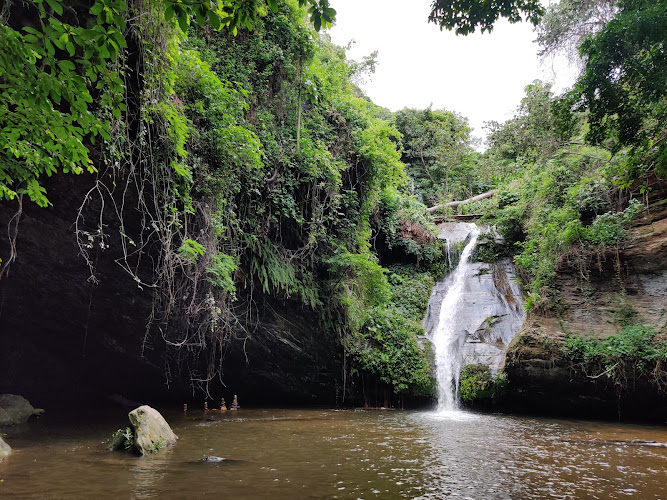
## Waterfalls, Forests & Protected Landscapes
### Kamalo Falls and the Missahoé forest
Within the Kpalimé–Atakora area, one of the best-documented attractions is Kamalo Falls:
– Located near the commune of Missahoé, in the Kloto Prefecture, in the heart of the Missahoé protected forest.
– The waterfall is fed by a stream originating on Mont Kloto and flows through the forested hills.
– Multiple sources describe Kamalo as the most visited waterfall in Togo, and note that a paved road between Kpalimé and Kuma-Konda makes it relatively accessible.
The Missahoé Forest Reserve itself covers about 5,000 hectares of steep, semi-deciduous forest, with altitudes between roughly 250 m and the higher ridges. It’s home to a mix of native tree species and has documented environmental pressures linked to settlement and agriculture.
For responsible travel planning, that means:
– You’re in a protected forest zone with ongoing conservation concerns.
– Any trekking or waterfall visit should treat paths, litter, and water sources with care to avoid compounding existing pressure.
### Other waterfalls around the Atakora slopes near Kpalimé
Beyond Kamalo, documented waterfalls in the wider Kpalimé–Atakora area include:
– Cascade de Womé – a waterfall near Kpalimé noted in recent descriptions for its accessible, stepped descent (hundreds of constructed steps with handrails) and year-round flow.
– Cascade de Kpimé – a waterfall near Kpalimé with a known hiking approach from nearby villages; reviews describe the route as a worthwhile hike through dam and forest scenery.
– Additional falls in the Kpalimé hinterland (e.g., Tomegbé, Yikpa, etc.) are specifically mentioned in current travel reporting as hiking targets for visitors staying in Kpalimé. on the Go
Some writers describe waterfalls on the Togo–Ghana border (Yikpa/Wli) as among the highest in West Africa, but that is a comparative, region-wide claim and can vary depending on the dataset used.
Given the lack of a single authoritative “highest waterfall” list for the region, it’s more accurate to frame them as major rather than definitively “number one.”
—
## Culture, History & Communities in the Atakora Area
The hills and plateaux around Kpalimé are not empty landscapes – they’re home to communities with deep histories tied to the mountains.
### Kpalimé, Agomé communities and colonial layers
Kpalimé’s origins are linked to the Agomé people, part of the wider Ewe cultural–linguistic world. Traditional accounts describe how Agomé groups moved from earlier settlements and eventually founded several villages in the area, including those on the slopes of Mount Kloto and on the plains.
Nearby communes like Agomé-Yoh and Missahoé, both within or beside the Missahoé forest, are explicitly connected with:
– The traditional authority of the Agomé people,
– Archaeological remains and buildings from the German and later French colonial periods (governor’s house, cemeteries, judicial and administrative structures).
This is part of a broader pattern across Togo:
– French acts as the official and administrative language,
– Ewe and other Gbe-family languages (such as Gen/Mina) are widely spoken in the south,
– Multiple ethnic groups co-exist, often combining Christianity, local traditional belief systems, and Islam in complex ways.
For visitors, that means the Atakora landscapes near Kpalimé are also:
– Agricultural zones (notably coffee and cocoa around Kpalimé and Missahoé),
– Cultural landscapes – shrines, cemeteries, colonial remains, and living villages – not just hiking backdrops.
—
## Practical Tips for Visiting the Atakora Range from Kpalimé
Because your prompt restricts us to verifiable facts, this section sticks to what can be sourced rather than anecdotal advice.
### When to go
– For the Atakora region in neighbouring Benin, a widely used French guide notes that the dry season from November to March is considered the best period for visiting, with easier conditions for roads and outdoor activities.
– Climate descriptions for the Kpalimé area and the Plateaux Region highlight a humid tropical setting with significant rainfall and only a few dry months, matching the idea that dry-season visits offer more reliable trail access. Routes
Table of Contents
Key Highlights
Chaine de l
Location
Places to Stay Near Chaine de l'Atakora
Find and Book a Tour
Explore More Travel Guides
No reviews found! Be the first to review!
Traveler Reviews for Chaine de l
There are no reviews yet. Be the first one to write one.
Have you visited Chaine de l? Help other travelers by sharing your review.
You Might Also Like
Hôtel Le Geyser
Cascade de Womé
Hotel Royal
Find Accommodations Nearby
Recommended Tours & Activities
Visitor Reviews
There are no reviews yet. Be the first one to write one.
Share Your Experience
Have you visited Chaine de l? Help other travelers by leaving a review.