
Caraguatatuba
About Caraguatatuba
Key Features
More Details
Updated April 16, 2024
## Caraguatatuba, Brazil: Practical Guide to São Paulo’s North-Coast “Capital”
Caraguatatuba – often shortened to Caraguá – is the largest city on the north coast of São Paulo state and a major base for exploring the Atlantic coast between Ubatuba and São Sebastião. Officially, it’s a municipality in the Litoral Norte region, squeezed between the Atlantic Ocean and the Serra do Mar mountain range and home to parts of the Serra do Mar State Park, a key protected Atlantic Forest area.
### Where Is Caraguatatuba and Why It Matters
Caraguatatuba sits about 175–178 km from São Paulo city, connected primarily by the Tamoios Highway (SP-099), which drops from the inland valley down to the sea. Paulo Secreto This makes it one of the most accessible coastal getaways for people starting in São Paulo or São José dos Campos.
The city has:
– Area: about 485 km²
– Population (official 2022 census): 134,873 residents
– Recent 2025 estimate: ~136,500 residents (model-based estimate, not an official census) Population Review
Some English-language sites still show older population counts from 2010 or 2017. Those figures are now outdated; the 2022 census is the latest official baseline, and 2025 figures are projections layered on top of that. Population
Caraguatatuba’s economy mixes tourism and agriculture, but for travelers its role is clear: it’s a hub city with infrastructure (shops, medical services, long-distance buses) and a string of beaches that feel very different from one another.
—
## Beaches of Caraguatatuba: How They Actually Differ
The municipality has 17 official beaches running north–south along the coast. Rather than trying to hit them all, it’s more useful to group them by vibe and conditions.
### 1. Martim de Sá: Livelier Urban Beach
Praia Martim de Sá is one of the best-known beaches on the north coast of São Paulo and frequently appears on “top things to do” lists for Caraguatatuba.
What to expect:
– A developed seafront with kiosks and services
– Good structure for a full beach day (food, drinks, rentals)
– More movement, especially on weekends and holidays
Because of its popularity, it’s not where you go for solitude, but it’s a strong base if you want everything in walking distance.
### 2. Indaiá: Family-Oriented and Flat Promenade
Praia do Indaiá often gets flagged as a family-friendly choice, with calm waters and a promenade that works for strollers, wheelchairs, and evening walks.
Useful details:
– Flatter seafront, which can help with mobility issues
– Open spaces for bikes and kids’ scooters
– Easy access to services and city buses
If you’re traveling with kids or older relatives and want quick access back into town, Indaiá is a solid compromise.
### 3. Cocanha, Mocóca, and Tabatinga: North-End Beaches for Slower Days
On the northern stretch of Caraguatatuba you’ll find:
– Praia da Cocanha
– Praia da Mocóca
– Praia da Tabatinga
These beaches tend to be highlighted for:
– Calmer waters on many days, compared with exposed surf beaches
– Possibility of boat trips from the beach to nearby islets (where offered by licensed operators)
– A slightly more residential, less urban feel than the central waterfront
They’re good options if you’re staying a few days and want a “home beach” that doesn’t feel like a city boulevard.
### 4. Massaguaçu and Capricórnio: Stronger Waves and Scenic Backdrop
Praia do Massaguaçu and neighboring Praia do Capricórnio sit on a more open stretch of coast.
Key points you should actually plan around:
– Stronger, more powerful waves; Massaguaçu is cited as a surfing spot and isn’t always recommended for casual swimming, particularly for children or weak swimmers.
– Scenic ocean views and a more “raw” coastline, which appeals to photographers and people who like long walks rather than pure swimming days
If you go here, check local safety flags and lifeguard guidance before entering the water; conditions can change quickly along this coast.
### 5. Central, Camaroeiros, and Praia Grande: In and Around Town
Near the urban core you’ll find:
– Praia do Centro (Central Beach)
– Praia do Camaroeiro
– Praia Grande
These are practical if you’re staying downtown and want to combine errands, restaurants, and a quick swim. Central Beach and Camaroeiros appear in many general travel guides and are often used as reference points for city events.
Water quality along urban beaches on Brazil’s coast can fluctuate, so it’s worth checking local environmental bulletins (for example, state or municipal reports) if water pollution is a concern for you.
—
## Beyond the Sand: Viewpoints, Shopping, and Culture
### Morro Santo Antônio Viewpoint
Morro Santo Antônio is a hill with panoramic views over Caraguatatuba’s bay and surrounding coastline. It appears on several “things to do” lists and is popular for short hikes or drives to lookouts.
From the top, you can:
– Get orientation on how the beaches line up along the bay
– Photograph the curve of the coastline and Serra do Mar backdrop
– Watch the light change late in the afternoon
The climb involves steep segments; if you have mobility or heart issues, check current access options (there are road approaches as well as trails, and these can change with weather and maintenance).
### Cultural Stops: Museums and Squares
For a coastal city, Caraguatatuba has a modest but useful set of cultural venues:
– Caraguatatuba Art and Culture Museum
– Polo Cultural Prof. Adaly Coelho Passos Museum
– Diogenes Ribeiro de Lima Square
– Praça de Eventos (Event Square), which hosts shows and public gatherings
These spots are handy on rainy days or for travelers who want some context beyond the beach. Programming and opening hours can change, so verify times close to your visit via municipal or venue channels rather than relying on old blog posts.
### Shopping and Everyday Logistics
Two names that come up repeatedly in travel resources:
– Serramar Parque Shopping – the largest shopping center in the region, with chain stores, food court, and services.
– Caraguá Beach Shopping Mall – smaller, but centrally located near the waterfront.
For longer stays, these malls are useful for:
– Picking up SIM cards or topping up data
– Buying beach gear without resort mark-ups
– Accessing ATMs from Brazilian bank networks
—
## Nature and the Atlantic Forest
Caraguatatuba’s inland boundary runs into the Serra do Mar and the Serra do Mar State Park, a protected section of Atlantic Forest that stretches along much of the São Paulo coastline.
What this means in practice:
– You can combine days on the beach with short hikes or waterfall visits in forested areas, often arranged through local tour operators.
– The region is important for biodiversity and water resources, so sticking to marked trails and licensed guides is not just a nice-to-have; it directly supports conservation.
Trail access, safety rules, and guide requirements can change because of landslides, heavy rain, or environmental policy updates, so always check the most recent park information rather than relying on generic trip reports from years ago.
—
## Climate and Best Time to Visit
Most references describe Caraguatatuba as having a tropical coastal climate, with warm, humid summers and milder winters. Library
In broad strokes:
– Summer (Dec–Mar):
– Hottest and most humid period
– Peak Brazilian holiday season, especially around Christmas, New Year, and Carnival
– Higher prices and heavier traffic on the Tamoios Highway and coastal roads
– Autumn & Spring (Apr–Jun, Sep–Nov):
– Often a better balance between warmth and crowds
– Still good beach weather on many days, but with fewer domestic vacation peaks
– Winter (Jun–Aug):
– Milder temperatures; good for travelers who don’t need peak heat
– Some days will be cloudy or windy; sea temperatures are cooler but still swimmable for many visitors
Climate norms are shifting worldwide; historic averages don’t always match current patterns. When packing, it’s worth checking recent monthly conditions for Caraguatatuba in the specific year you’re traveling rather than relying only on long-term climate charts.
—
## Getting In and Around
### Reaching Caraguatatuba
Current travel descriptions consistently mention road access via the Tamoios Highway from the interior toward the coast. Library
Typical patterns:
– From São Paulo city: drive or bus via São José dos Campos and then follow SP-099 to the coast.
– From neighboring coastal towns: regional buses and road links connect Caraguatatuba with Ubatuba to the northeast and São Sebastião/Ilhabela to the south.
Bus schedules and routes can change with operator contracts and seasonal demand, so always pull the latest information from Brazilian bus search platforms or directly from companies.
### Getting Around Town
Within Caraguatatuba itself:
– The central beachfront strip is walkable for many travelers.
– Local buses and taxis/app-based services (where available) connect neighborhoods and beaches, though service frequency can vary by district and time of day.
– For exploring multiple beaches and nearby municipalities in a single trip, renting a car often gives more flexibility, but factor in parking and summer traffic delays.
—
## Accommodation Snapshot
Recent descriptions highlight Caraguatatuba as offering everything from budget hostels to upscale resorts, with options spread along the main beaches and urban core. Library
You’ll generally find:
– City-center hotels and guesthouses near Central Beach and the bus station
– Beachfront pousadas (guesthouses) along Martim de Sá, Indaiá, and other beaches
– Holiday apartments and short-term rentals scattered throughout residential areas
Table of Contents
Key Highlights
Caraguatatuba
Location
Places to Stay Near Caraguatatuba
Find and Book a Tour
Explore More Travel Guides
No reviews found! Be the first to review!
Traveler Reviews for Caraguatatuba
There are no reviews yet. Be the first one to write one.
Have you visited Caraguatatuba? Help other travelers by sharing your review.
You Might Also Like
Chafariz histórico Massaguaçu
Cachoeira da Água Branca
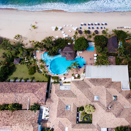
Costa Verde Tabatinga Hotel
Find Accommodations Nearby
Recommended Tours & Activities
Visitor Reviews
There are no reviews yet. Be the first one to write one.
Share Your Experience
Have you visited Caraguatatuba? Help other travelers by leaving a review.