
Brahmanbaria City
About Brahmanbaria City
Key Features
More Details
Updated April 15, 2024
## Brahmanbaria City, Bangladesh: History, Rivers and Sweet Heritage on the Titas
Brahmanbaria City (often written Brahmanbaria or colloquially B-Baria) is an important regional centre in east-central Bangladesh. It is the headquarters of Brahmanbaria District in the Chattogram Division and one of the oldest municipalities in the country, having gained municipal status in the 19th century.
Today the municipality has a population of around 264,000 people (2022 census), making it a mid-sized Bangladeshi city with a relatively high reported literacy rate of over 83%. It sits close to the border with India’s Tripura state, on the Titas River, with the Meghna River to the west – a classic riverine landscape shaped by the wider Gangetic Plain.
This guide focuses on verified facts about Brahmanbaria City and its surroundings, with clear notes where figures come from older sources so you can judge their freshness.
—
## A Short History of Brahmanbaria
### Name and early roots
Local historical summaries describe Brahmanbaria as part of Samatata Janapada, an ancient region of Bengal.
The city’s name is linked to the Sena dynasty period. According to district and city histories, a shortage of Brahmin priests for worship led King Lakshman Sen to relocate Brahmin families to this area; as those Brahmin households (baris) took root, the place became known as Brahmanbaria – literally “Brahmins’ houses.”
Nearby Sarail, about 10 km north of today’s city, later became the first, temporary capital of the regional ruler Isa Khan, a key figure in late-16th-century Bengal politics.
### From Mughal muslin to anti-colonial protest
During the Mughal era, Brahmanbaria gained a reputation for its fine muslin cloth, part of the broader muslin tradition of eastern Bengal.
In the early 20th century, the area appears repeatedly in accounts of the Swadeshi movement during British rule. Local histories record, for example, that during the agitation following the 1905 partition of Bengal, Brahmanbaria produced revolutionaries such as Ullaskar Datta, who was deported to the Andamans, and that in 1931, Suniti Chowdhury and Shanti Ghosh assassinated District Magistrate C.C.B. Stevens at his residence in Brahmanbaria.
### Municipality and district capital
Key administrative milestones:
– 1869 – Brahmanbaria Town becomes a municipality.
– 1984 – Brahmanbaria is separated from Comilla (Tippera) and becomes its own district, with Brahmanbaria City as the headquarters.
Today the city is a pourashava (municipal town) with 20 wards and functions as the district’s main administrative, commercial, and transport hub.
### Role in the 1971 Liberation War
Military histories of the Indo-Pakistan War of 1971 note that Pakistan Army planners expected India’s main eastern offensive to push along the Akhaura–Brahmanbaria axis, giving this region strategic importance during the war.
The war ended with the surrender of about 93,000 Pakistani troops on 16 December 1971, observed in Bangladesh as Bijoy Dibos (Victory Day). Brahmanbaria, like many districts, remembers this date through local commemorations.
—
## Geography and Climate: What Conditions to Expect
Brahmanbaria stands in the east-central part of Bangladesh, within the Chattogram Division. Nearby major cities include Dhaka, Comilla, Narayanganj, and India’s Agartala across the border.
The city lies:
– On the banks of the Titas River, a distributary of the Meghna. Real Estate Investments
– At a low elevation of roughly 11–15 metres above sea level.
### Climate
Multiple climate datasets classify Brahmanbaria’s weather as tropical wet and dry (Köppen Aw), with a marked monsoon.
From long-term climate tables:
– Mean daily maximum temperature averages about 31 °C (87 °F) over the year, with hotter months in March–May (~32–33 °C) and cooler highs around 25–29 °C in winter.
– Relative humidity in eastern Bangladesh drops to its lowest averages between January and March, with a recorded minimum around 58.5% at Brahmanbaria in March, and exceeds 80% during the June–September monsoon.
These numbers come from national climate references and may not fully reflect recent climate-change-driven variability, but they remain the best published baselines as of 2025.
—
## Culture, Food and Economy
### Chhanamukhi – a GI-protected sweet
Brahmanbaria is strongly associated with chhanamukhi (chanamukhi), a local sweet made from fried cottage cheese pieces soaked or coated in sugar syrup.
Key verified facts:
– Chhanamukhi originated in Brahmanbaria District.
– On 24 September 2024, chhanamukhi was formally recognised as a Geographical Indication (GI) product of Bangladesh.
– Media coverage in 2024–2025 highlights around 180 years of local production, particularly linked to Mahadev Mishtanno Bhandar, though precise founding dates vary slightly by source and should be treated as approximate. Daily Star
If you see “Brahmanbaria chhanamukhi” or “Brahmanbarian chhanamukhi” in shops elsewhere in Bangladesh (or in parts of India such as Nadia and Murshidabad), those names are referencing this origin. Bengal
### Religion and languages
District-level census data from 2022 shows Brahmanbaria District as majority Muslim, with a Hindu minority and very small numbers of other religions; Muslims account for roughly 93%, Hindus for about 6.7%, and others a fraction of a percent.
City-level breakdowns for religion aren’t always published separately, so applying district percentages directly to the city would be an assumption. What is clear is that:
– Bangla (Bengali) is the dominant language.
– You will encounter both mosques and Hindu temples among local places of worship, reflected in listings that include sites such as Kalibari Temple in the wider Brahmanbaria area.
### Titas Gas Field and regional economy
One of the most significant features around Brahmanbaria is the Titas Gas Field, located in the district:
– It is recognised as Bangladesh’s largest natural gas field, discovered in 1962 and producing commercially since 1968.
– The field lies roughly 100 km northeast of Dhaka and is operated under Bangladesh Gas Fields Company Limited.
Academic and technical studies from the late 2010s reported gas seepage issues around parts of the Titas field, with leaks detected through thousands of holes in paddy fields, water bodies, and along the Titas River. Publishing Group These assessments are several years old; they document environmental risks at that time rather than the current state of mitigation.
More broadly, official and encyclopedic sources list agriculture, fishing, power and electricity, and natural gas as key sectors for the district economy.
—
## Places to Visit In and Around Brahmanbaria
Most formal “tourist spots” lie in the district rather than strictly within the compact municipal core, but they are typically visited on day trips from Brahmanbaria City.
### Haripur Zamindar Bari (Haripur Barabari)
– Type: Historic zamindar (landlord) palace
– Location: Horipur Union, Nasirnagar Upazila, Brahmanbaria District, east of the Titas River.
– Built in the 18th century, associated with Krishna Prasad Roy Choudhury (c. 1870–1936).
Reports describe a large mansion complex sometimes called Horipur Rajbari or Boro Bari, with features such as a sizeable pond and associated temple structures, representing the opulence of the zamindar era. Asian Age
### Gokarna Nawab Bari Complex
Listed by Bangladeshi tourism portals as a key attraction of Brahmanbaria District, the Gokarna Nawab Bari Complex is a historic estate. Verified open-source details are relatively limited, but it appears consistently in district “top attraction” lists.
### Arifail Mosque
The Arifail Mosque is a historic mosque in Brahmanbaria District, noted for its architecture and cultural significance. It frequently appears alongside Haripur Zamindar Bari and Hatir Pool as part of heritage-focused itineraries.
### Hatir Pool (Hatirpul)
Hatir Pool (or Hatirpul) is an old bridge structure in the district. According to district history, a bridge with this name was built during the Mughal period under a local official named Shahbaz Khan (c. mid-17th century) to allow elephants to cross a canal, and is mentioned in modern tourist-spot listings.
### Dhoronti Haor and other natural spots
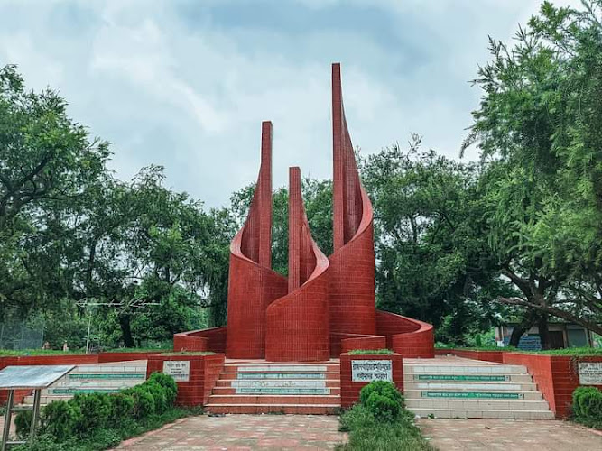
District tourism listings also highlight Dhoronti Haor, a wetland area noted for boating and seasonal birdlife, and Faruki Park, a green space closer to the city.
While descriptions often emphasise scenery, up-to-date infrastructure details (boat standards, safety measures, etc.) are not always available in English-language sources, so treat those aspects as unknown rather than assumed.
### City-area parks and temples
Travel platforms list several sites directly associated with Brahmanbaria town and its surroundings, including:
– Heritage Park – a public park in or near Brahmanbaria.
– Kalibari Temple – a Hindu temple dedicated to the goddess Kali.
– Nitta Uddyan Old Hindu Monastery – listed as a notable historical-religious site under “sights and historical landmarks.”
These entries confirm the existence and general type of each site; more granular details (exact founding dates, opening hours, or current maintenance level) are not consistently documented in the sources used here.
### How “developed” is tourism?
At least one international tour-booking marketplace currently returns no dedicated activities for Brahmanbaria District, even while it lists extensive tours for Dhaka and other cities. This doesn’t measure actual visitor numbers, but it does show that mass-market organised tourism infrastructure is still limited in English-language platforms, and that most visitors likely travel independently or via local operators not indexed there.
—
## Getting To Brahmanbaria City
### By train from Dhaka
Verified transport data shows:
Table of Contents
Key Highlights
Brahmanbaria City
Location
Places to Stay Near Brahmanbaria City
Find and Book a Tour
Explore More Travel Guides
No reviews found! Be the first to review!
Traveler Reviews for Brahmanbaria City
There are no reviews yet. Be the first one to write one.
Have you visited Brahmanbaria City? Help other travelers by sharing your review.
You Might Also Like
Biri Land
Faruki Park
Brahmanbaria Sadar Upazila
Find Accommodations Nearby
Recommended Tours & Activities
Visitor Reviews
There are no reviews yet. Be the first one to write one.
Share Your Experience
Have you visited Brahmanbaria City? Help other travelers by leaving a review.