Argelia Manizales
About Argelia Manizales
Description
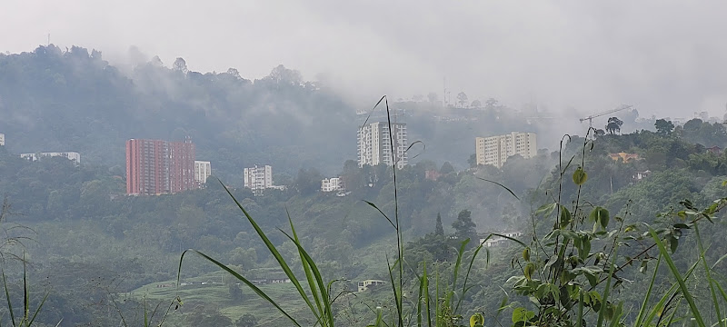
Argelia Manizales is one of those hiking spots that doesn't scream for attention but quietly rewards those who seek it out. Located in the coffee region of Colombia, this hiking area offers an authentic mountain experience that feels worlds away from the typical tourist circuits you'll find elsewhere in the country. And honestly, that's part of its charm. The trails here wind through landscapes that shift between coffee plantations, cloud forests, and rural farmland where locals still work the land the way their grandparents did. You won't find paved pathways or fancy visitor centers here – this is raw hiking in the truest sense. The terrain can be challenging at times, with steep inclines that'll test your legs and lungs, but the payoff comes in those unexpected moments when you round a corner and suddenly the entire valley opens up before you. What makes Argelia particularly special is how it manages to feel both accessible and remote at the same time. You're still within reasonable distance of Manizales proper, yet once you're on the trails, you might as well be in another world entirely. The air smells different here – thick with moisture and the earthy scent of vegetation that never quite dries out. Birds you've probably never heard of call from the canopy, and if you're lucky (and quiet), you might spot wildlife that's become increasingly rare in other parts of Colombia. I've always believed that the best hikes are the ones where you feel like you've earned something by the end, and Argelia delivers on that front. This isn't a leisurely stroll through a city park. You'll get muddy, you'll probably slip at least once, and your calves will remind you of this hike for a day or two afterward. But that's exactly why it's worth doing.Key Features
- Extensive trail network suitable for various skill levels, though most paths lean toward intermediate to advanced difficulty
- Dog-friendly trails, making it perfect for travelers who refuse to leave their four-legged companions behind at the hotel
- Authentic coffee region landscape with working plantations visible throughout the hike
- Minimal commercial development preserving the natural character of the area
- Cloud forest ecosystems with unique biodiversity found in few other accessible locations
- Opportunities for birdwatching with species endemic to the Colombian Andes
- Local farming communities along the routes offering glimpses into traditional mountain life
- Panoramic viewpoints overlooking the Manizales valley and surrounding peaks
- Cooler mountain climate providing relief from Colombia's coastal heat
- Relatively undiscovered by international tourists, offering solitude increasingly hard to find
Best Time to Visit
Here's the thing about hiking in the Colombian coffee region – there's never a completely dry season, so you might as well embrace the fact that you'll probably encounter some rain regardless of when you visit. But that doesn't mean all times are created equal. December through March tends to offer the most stable weather conditions. You'll still see afternoon clouds rolling in (they always do in the mountains), but your chances of completing a full hike without getting soaked improve considerably. The mornings during these months often feature surprisingly clear skies, and that's when you want to hit the trails. By noon, conditions typically shift, and those afternoon showers become more likely. July and August represent another decent window, though temperatures can drop more noticeably during these months. Bring layers – and I mean actually bring them, don't just think about it and then leave your jacket at the hotel like I did once. The temperature difference between sun and shade can be dramatic, and when that wind picks up at higher elevations, you'll want something more than a t-shirt. April, May, October, and November? Those are the wettest months. The trails turn into mudslides, visibility drops, and honestly, unless you're training for something that requires miserable conditions, I'd suggest picking different months. Some people claim the landscape looks "more alive" during the rainy season, and sure, everything's greener, but you also can't see much of it through the fog. Early morning starts work best regardless of season. Local hikers typically begin their treks around 6 or 7 AM, and there's wisdom in that tradition. The light is better for photography, the trails are less crowded (though "crowded" is relative here – you won't encounter tour bus crowds), and you can finish before the afternoon weather makes things complicated. Weekdays see fewer visitors than weekends when locals from Manizales escape the city for outdoor time. If solitude ranks high on your priority list, plan accordingly.How to Get There
Getting to Argelia requires a bit more effort than just calling an Uber, but that's partly why it remains relatively unspoiled. From Manizales city center, you're looking at roughly an hour's journey, maybe a bit more depending on road conditions and how many coffee trucks you get stuck behind on the mountain roads. Your realistic options include renting a vehicle or hiring a taxi for the day. Public transportation exists but runs infrequently and won't drop you directly at trailheads – you'd still face a significant walk just to reach the starting points. For what it's worth, having your own wheels makes everything easier, especially if you want flexibility in your schedule or plan to explore multiple trail access points. The roads out here are paved but narrow, winding through mountains in that way that makes passengers grip their armrests and pray. If you're not comfortable driving in mountainous terrain or your experience with stick shifts is limited (many rental vehicles in Colombia are manual transmission), hiring a driver makes sense. Local taxi drivers know these roads intimately and can often provide information about trail conditions that you won't find online. GPS works reasonably well in the area, though cell signals can be spotty once you're actually on the trails. Download offline maps before leaving Manizales, and honestly, don't rely entirely on technology. Asking locals for directions remains surprisingly effective – most people know the area well and can point you toward the better trailheads. Parking near trail access points is informal at best. You'll typically pull off to the side of the road where you see space. Theft isn't particularly common in this area, but don't leave valuables visible in your vehicle. Actually, just don't leave valuables in your vehicle period, because why would you bring them on a hike anyway? Some travelers arrange transportation through their hotels or hostels in Manizales, which can work well if you're uncomfortable navigating on your own. The downside is you're working on someone else's schedule rather than your own.Tips for Visiting
Waterproof everything matters here. And I don't mean water-resistant – I mean properly waterproof. Your phone, your camera, extra clothes, snacks – if you care about it staying dry, it needs protection. Zip-lock bags work in a pinch, but a quality dry bag is worth the investment if you plan multiple hikes in the region. The trails aren't marked with the same obsessive clarity you'd find in, say, national parks in the United States or Europe. Trail markers exist but sporadically. It's relatively easy to take a wrong turn, especially where paths branch. Downloading a trail app like Maps.me or Gaia GPS and using it alongside asking locals for directions before starting creates a safety net. Bring more water than you think you need. Yeah, it's heavy, but dehydration at altitude amplifies fatigue quickly. The streams and water sources you encounter aren't safe for drinking without treatment, so don't count on refilling along the way unless you're carrying purification tablets or a filter. Your footwear will make or break this experience. Those cute trail shoes with minimal tread? Leave them for easier hikes. You want proper hiking boots with ankle support and aggressive tread patterns. The mud here has a special quality – slippery doesn't quite capture it. It's more like nature's own non-stick coating applied to rocks and roots. Dogs are welcome on these trails, which is genuinely wonderful for those traveling with pets. But be realistic about your dog's fitness level and the distance you're attempting. The terrain demands more energy than flat walking, and not every dog is up for serious mountain hiking regardless of how enthusiastic they seem at the trailhead. Pack snacks with protein and carbohydrates. Trail mix, energy bars, fruit – whatever keeps your energy steady. You won't find refreshment stands or convenience stores once you're hiking, so whatever you need, you're carrying in. A basic first aid kit belongs in your pack. Bandages, pain relievers, any personal medications, and maybe some anti-diarrheal medication just in case. Colombian mountain water has unique bacteria that visitors' stomachs sometimes object to vigorously. Tell someone where you're going and when you expect to return. Cell coverage is unreliable in many areas, so if something goes wrong, you can't necessarily call for help immediately. This isn't meant to scare you – the area is generally safe – but basic precautions make sense anywhere you're hiking in remote terrain. Respect the working farmland you'll pass through. Coffee plantations aren't public parks, even if trails cross through them. Don't pick coffee cherries, don't litter, and if you encounter farm workers, a friendly greeting goes a long way. These are people's livelihoods, not attractions. The weather changes rapidly in mountain environments. That clear morning can turn stormy within an hour. Carry a lightweight rain jacket always, even when the forecast looks perfect. Forecasts in mountain areas are suggestions rather than promises. Start earlier than feels necessary. Those trails take longer than they look on a map, especially when you factor in mud, steep sections, and photo stops. Better to finish with time to spare than find yourself rushing back as daylight fades.Key Features
- Coffee-region scenery with views over plantations and montane valleys
- Trails combining shade forest, rural paths and ridgeline viewpoints
- Relatively uncrowded, authentic local hiking experience
- Good birdwatching and potential sightings of regional flora (orchids, bromeliads)
- Opportunities to combine hiking with visits to nearby fincas/coffee farms
More Details
Updated January 17, 2026
Table of Contents
Description
Argelia Manizales is one of those hiking spots that doesn’t scream for attention but quietly rewards those who seek it out. Located in the coffee region of Colombia, this hiking area offers an authentic mountain experience that feels worlds away from the typical tourist circuits you’ll find elsewhere in the country. And honestly, that’s part of its charm.
The trails here wind through landscapes that shift between coffee plantations, cloud forests, and rural farmland where locals still work the land the way their grandparents did. You won’t find paved pathways or fancy visitor centers here – this is raw hiking in the truest sense. The terrain can be challenging at times, with steep inclines that’ll test your legs and lungs, but the payoff comes in those unexpected moments when you round a corner and suddenly the entire valley opens up before you.
What makes Argelia particularly special is how it manages to feel both accessible and remote at the same time. You’re still within reasonable distance of Manizales proper, yet once you’re on the trails, you might as well be in another world entirely. The air smells different here – thick with moisture and the earthy scent of vegetation that never quite dries out. Birds you’ve probably never heard of call from the canopy, and if you’re lucky (and quiet), you might spot wildlife that’s become increasingly rare in other parts of Colombia.
I’ve always believed that the best hikes are the ones where you feel like you’ve earned something by the end, and Argelia delivers on that front. This isn’t a leisurely stroll through a city park. You’ll get muddy, you’ll probably slip at least once, and your calves will remind you of this hike for a day or two afterward. But that’s exactly why it’s worth doing.
Key Features
- Extensive trail network suitable for various skill levels, though most paths lean toward intermediate to advanced difficulty
- Dog-friendly trails, making it perfect for travelers who refuse to leave their four-legged companions behind at the hotel
- Authentic coffee region landscape with working plantations visible throughout the hike
- Minimal commercial development preserving the natural character of the area
- Cloud forest ecosystems with unique biodiversity found in few other accessible locations
- Opportunities for birdwatching with species endemic to the Colombian Andes
- Local farming communities along the routes offering glimpses into traditional mountain life
- Panoramic viewpoints overlooking the Manizales valley and surrounding peaks
- Cooler mountain climate providing relief from Colombia’s coastal heat
- Relatively undiscovered by international tourists, offering solitude increasingly hard to find
Best Time to Visit
Here’s the thing about hiking in the Colombian coffee region – there’s never a completely dry season, so you might as well embrace the fact that you’ll probably encounter some rain regardless of when you visit. But that doesn’t mean all times are created equal.
December through March tends to offer the most stable weather conditions. You’ll still see afternoon clouds rolling in (they always do in the mountains), but your chances of completing a full hike without getting soaked improve considerably. The mornings during these months often feature surprisingly clear skies, and that’s when you want to hit the trails. By noon, conditions typically shift, and those afternoon showers become more likely.
July and August represent another decent window, though temperatures can drop more noticeably during these months. Bring layers – and I mean actually bring them, don’t just think about it and then leave your jacket at the hotel like I did once. The temperature difference between sun and shade can be dramatic, and when that wind picks up at higher elevations, you’ll want something more than a t-shirt.
April, May, October, and November? Those are the wettest months. The trails turn into mudslides, visibility drops, and honestly, unless you’re training for something that requires miserable conditions, I’d suggest picking different months. Some people claim the landscape looks “more alive” during the rainy season, and sure, everything’s greener, but you also can’t see much of it through the fog.
Early morning starts work best regardless of season. Local hikers typically begin their treks around 6 or 7 AM, and there’s wisdom in that tradition. The light is better for photography, the trails are less crowded (though “crowded” is relative here – you won’t encounter tour bus crowds), and you can finish before the afternoon weather makes things complicated.
Weekdays see fewer visitors than weekends when locals from Manizales escape the city for outdoor time. If solitude ranks high on your priority list, plan accordingly.
How to Get There
Getting to Argelia requires a bit more effort than just calling an Uber, but that’s partly why it remains relatively unspoiled. From Manizales city center, you’re looking at roughly an hour’s journey, maybe a bit more depending on road conditions and how many coffee trucks you get stuck behind on the mountain roads.
Your realistic options include renting a vehicle or hiring a taxi for the day. Public transportation exists but runs infrequently and won’t drop you directly at trailheads – you’d still face a significant walk just to reach the starting points. For what it’s worth, having your own wheels makes everything easier, especially if you want flexibility in your schedule or plan to explore multiple trail access points.
The roads out here are paved but narrow, winding through mountains in that way that makes passengers grip their armrests and pray. If you’re not comfortable driving in mountainous terrain or your experience with stick shifts is limited (many rental vehicles in Colombia are manual transmission), hiring a driver makes sense. Local taxi drivers know these roads intimately and can often provide information about trail conditions that you won’t find online.
GPS works reasonably well in the area, though cell signals can be spotty once you’re actually on the trails. Download offline maps before leaving Manizales, and honestly, don’t rely entirely on technology. Asking locals for directions remains surprisingly effective – most people know the area well and can point you toward the better trailheads.
Parking near trail access points is informal at best. You’ll typically pull off to the side of the road where you see space. Theft isn’t particularly common in this area, but don’t leave valuables visible in your vehicle. Actually, just don’t leave valuables in your vehicle period, because why would you bring them on a hike anyway?
Some travelers arrange transportation through their hotels or hostels in Manizales, which can work well if you’re uncomfortable navigating on your own. The downside is you’re working on someone else’s schedule rather than your own.
Tips for Visiting
Waterproof everything matters here. And I don’t mean water-resistant – I mean properly waterproof. Your phone, your camera, extra clothes, snacks – if you care about it staying dry, it needs protection. Zip-lock bags work in a pinch, but a quality dry bag is worth the investment if you plan multiple hikes in the region.
The trails aren’t marked with the same obsessive clarity you’d find in, say, national parks in the United States or Europe. Trail markers exist but sporadically. It’s relatively easy to take a wrong turn, especially where paths branch. Downloading a trail app like Maps.me or Gaia GPS and using it alongside asking locals for directions before starting creates a safety net.
Bring more water than you think you need. Yeah, it’s heavy, but dehydration at altitude amplifies fatigue quickly. The streams and water sources you encounter aren’t safe for drinking without treatment, so don’t count on refilling along the way unless you’re carrying purification tablets or a filter.
Your footwear will make or break this experience. Those cute trail shoes with minimal tread? Leave them for easier hikes. You want proper hiking boots with ankle support and aggressive tread patterns. The mud here has a special quality – slippery doesn’t quite capture it. It’s more like nature’s own non-stick coating applied to rocks and roots.
Dogs are welcome on these trails, which is genuinely wonderful for those traveling with pets. But be realistic about your dog’s fitness level and the distance you’re attempting. The terrain demands more energy than flat walking, and not every dog is up for serious mountain hiking regardless of how enthusiastic they seem at the trailhead.
Pack snacks with protein and carbohydrates. Trail mix, energy bars, fruit – whatever keeps your energy steady. You won’t find refreshment stands or convenience stores once you’re hiking, so whatever you need, you’re carrying in.
A basic first aid kit belongs in your pack. Bandages, pain relievers, any personal medications, and maybe some anti-diarrheal medication just in case. Colombian mountain water has unique bacteria that visitors’ stomachs sometimes object to vigorously.
Tell someone where you’re going and when you expect to return. Cell coverage is unreliable in many areas, so if something goes wrong, you can’t necessarily call for help immediately. This isn’t meant to scare you – the area is generally safe – but basic precautions make sense anywhere you’re hiking in remote terrain.
Respect the working farmland you’ll pass through. Coffee plantations aren’t public parks, even if trails cross through them. Don’t pick coffee cherries, don’t litter, and if you encounter farm workers, a friendly greeting goes a long way. These are people’s livelihoods, not attractions.
The weather changes rapidly in mountain environments. That clear morning can turn stormy within an hour. Carry a lightweight rain jacket always, even when the forecast looks perfect. Forecasts in mountain areas are suggestions rather than promises.
Start earlier than feels necessary. Those trails take longer than they look on a map, especially when you factor in mud, steep sections, and photo stops. Better to finish with time to spare than find yourself rushing back as daylight fades.
Key Highlights
- Coffee-region scenery with views over plantations and montane valleys
- Trails combining shade forest, rural paths and ridgeline viewpoints
- Relatively uncrowded, authentic local hiking experience
- Good birdwatching and potential sightings of regional flora (orchids, bromeliads)
- Opportunities to combine hiking with visits to nearby fincas/coffee farms
Location
Places to Stay Near Argelia Manizales
Find and Book a Tour
Explore More Travel Guides
No reviews found! Be the first to review!
Traveler Reviews for Argelia Manizales
There are no reviews yet. Be the first one to write one.
Have you visited Argelia Manizales? Help other travelers by sharing your review.
Nearby Attractions
You Might Also Like

Manizales

Nomadic George Mural

University Museum Center Caldas
Find Accommodations Nearby
Recommended Tours & Activities
Visitor Reviews
There are no reviews yet. Be the first one to write one.
Share Your Experience
Have you visited Argelia Manizales? Help other travelers by leaving a review.