
Alabat Falls
About Alabat Falls
Key Features
More Details
Updated October 31, 2025
## Alabat Falls (Tumiis Falls), Alabat Island, Quezon — Practical Guide
Location: Barangay Villa Norte, Municipality of Alabat, Alabat Island, Quezon Province, Philippines
Coordinates: 14.1528462, 122.0213765 (approx. island interior; Villa Norte sits around 14.1328, 122.0487)
Type: Small coastal waterfall flowing near Lamon Bay
User rating noted: 5/5 (data provided)
> On Alabat Island, the cascade commonly referred to as “Alabat Falls” is locally known as Tumiis Falls in Barangay Villa Norte. The municipality’s own tourism page lists Tumiis Falls among its destinations, and multiple on-the-ground posts and reels place it in Villa Norte, confirming the local name and setting.
—
### Why it’s worth your time
– Coast-meets-mountain scenery: Tumiis Falls sits on the eastern side of Alabat Island where the Alabat Watershed Forest Reserve (AWFR) rises toward Mt. Camagong (the island’s highest point). Expect a compact waterfall in a green pocket with sea views nearby—more about setting than size.
– Protected landscape context: The AWFR (established under Proclamation No. 156) has been an active focus of conservation work; in May 5–9, 2025, DENR’s Regional Cave Assessment Team surveyed Tumiis Cave in Sitio Tumiis, Brgy. Villa Norte—the same micro-area hikers pass when visiting the falls. This underscores the site’s ecological sensitivity.
– Pair it with a summit or coastal stop: Mt. Camagong is the island high point and a known trekking route (mapped on AllTrails), and Alabat Cove offers calm beach time—easy half-day combos around the falls.
—
### Getting there (step-by-step)
1. Manila ➜ Atimonan Port (Quezon mainland):
Drive or bus via Lucena ➜ Atimonan (3–4 hours by car in light traffic based on resort/local operator guidance).
2. Ferry: Atimonan Port ➜ Alabat Port (island):
The Municipality of Alabat FAQ and Atimonan Port page list daily boat departures (operators include MV NHELSEA 2, MV VIVA FLOS CARMELI, MV PINOY RORO 1). Public posts mention around 30 minutes crossing time. Important: community-managed schedules change—verify same-day via port/operator numbers published on these pages.
3. Alabat Port ➜ Villa Norte (Tumiis Falls):
From the port, take a tricycle to Barangay Villa Norte; the barangay’s official coordinates place it on the island’s east, close to coastal hamlets and the AWFR foothills. From the village, locals point the short footpath to the falls. (Trail specifics vary with rains; ask on arrival.)
Alternate entries to the island exist (Perez/Quezon towns), but for the falls, the central town of Alabat ➜ Villa Norte route is the most straightforward for independent travelers.
—
### On the ground: what to expect
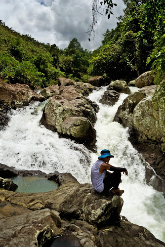
– Trail & access: Expect a short, informal footpath from Villa Norte to the cascade. Community videos and posts depict a compact chute with plunge spots and rock ledges—no major infrastructure (that’s part of the charm). Surfaces can be slick after rain.
– Setting: You’re within the Alabat Watershed Forest Reserve—a mosaic of second-growth forest, streams, and small caves (e.g., Tumiis Cave). Please stay on established ground and avoid soaps/sunscreens in the water.
– Crowds: This is low-traffic vs. mainland Quezon waterfalls (e.g., Aliw, Balagbag). Expect locals, weekenders, and hikers rather than big tour groups. (Mainstream lists of Quezon waterfalls rarely include Tumiis, another sign it remains under the radar.)
—
### Best time to visit
– Dry months (Dec–May) offer easier footing and clearer water. Note: Alabat’s climate shows no true dry season but has peak rainfall Nov–Jan—expect flashier flow but muddier ground then.
—
### Combine these stops for a full day
– Mt. Camagong trek: Marked as a ~12.7-mile out-and-back on AllTrails; commonly rated moderate. Only attempt if you’re prepared; start early and respect changing weather.
– Alabat Cove: Gentle beach interlude after the falls; simple amenities, natural feel.
– Barangay coast walk (Villa Norte): Community shoreline with views toward the Philippine Sea/Lamon Bay; bring cash for snacks. (Location confirmation via barangay profile.)
—
### Responsible, inclusive travel notes
– Protected-area etiquette: You’re in/near the AWFR—pack out trash, avoid loud music, and don’t enter caves without local authorization (DENR recently profiled Tumiis Cave for conservation).
– Community respect: Villa Norte is a small barangay. Always ask before flying drones or photographing people, and consider hiring local guides/trike drivers to keep spend local (standard practice in Philippine rural tourism).
—
### What to pack
– Footwear with grip (wet rock).
– Sun/rain protection (exposed sections + sudden showers).
– Dry bag & cash (no ATMs in barangay; limited signal).
– Filter bottle; avoid single-use plastics.
—
### Practicalities & safety
– Connectivity: Patchy outside town centers; download maps offline.
– Cash only: Bring small bills for tricycles and sari-sari stores.
– Emergency/health: The Alabat Island District Hospital and municipal offices are in/near Alabat town proper; still, treat the falls like a wilderness site—self-reliance matters. Finder
– Weather: Sudden squalls happen year-round on the Lamon Bay side; streams can swell quickly after cloudbursts.
—
### How this guide handles uncertain or changing info
– Boat schedules & operator details change frequently. The Municipality of Alabat FAQ and Atimonan Port page post times and contact numbers, but you should re-confirm on the day—pages show sample timetables (e.g., MV NHELSEA 2, MV VIVA FLOS CARMELI, MV PINOY RORO 1). Treat these as guidance, not guarantees.
– Exact trail distance to the falls isn’t formally published by the LGU; visuals and posts confirm a short walk from Villa Norte to the cascade. If conditions have changed (landslides, high water), consult locals before committing.
—
### Fast facts (recap)
– Local name: Tumiis Falls (often called Alabat Falls by visitors) in Barangay Villa Norte.
– Island high point near falls: Mt. Camagong.
– Protected area: Alabat Watershed Forest Reserve; active cave and biodiversity assessment in May 2025 (Tumiis Cave).
– Access: Atimonan Port ➜ Alabat Port ferry, then tricycle to Villa Norte. Verify same-day boat times.
—
#### Sources & verification
Municipal and local materials confirming destination status and access: Municipality of Alabat FAQ / Tourism list (incl. Tumiis Falls); Atimonan Port public schedule posts; DENR CALABARZON bulletin (Tumiis Cave, AWFR, May 2025); AllTrails (Mt. Camagong); PhilAtlas (Villa Norte coordinates/demographics); Alabat Island overview (island geography, climate).
If you need this adapted into a structured destination schema (JSON-LD) or a short “How to Go” box for SERP features, say the word and I’ll ship a drop-in block.
Table of Contents
- Key Highlights
- Location
- Places to Stay Near Alabat Falls
- Find and Book a Tour
- Explore More Travel Guides
- Alabat Falls (Tumiis Falls), Alabat Island, Quezon — Practical Guide
- Why it’s worth your time
- Getting there (step-by-step)
- On the ground: what to expect
- Best time to visit
- Combine these stops for a full day
- Responsible, inclusive travel notes
- What to pack
- Practicalities & safety
- How this guide handles uncertain or changing info
- Fast facts (recap)
- Nearby Places You Might Like
- Traveler Reviews for Alabat Falls
- Share Your Experience
Key Highlights
Coast-meets-mountain scenery: Tumiis Falls sits on the eastern side of Alabat Island where the Alabat Watershed Forest Reserve (AWFR) rises toward Mt. Camagong (the island’s highest point). Expect a compact waterfall in a green pocket with sea views nearby—more about setting than size. oai_citation:2‡Wikipedia
Protected landscape context: The AWFR (established under Proclamation No. 156) has been an active focus of conservation work; in May 5–9, 2025, DENR’s Regional Cave Assessment Team surveyed Tumiis Cave in Sitio Tumiis, Brgy. Villa Norte—the same micro-area hikers pass when visiting the falls. This underscores the site’s ecological sensitivity. oai_citation:3‡Heyzine
Pair it with a summit or coastal stop: Mt. Camagong is the island high point and a known trekking route (mapped on AllTrails), and Alabat Cove offers calm beach time—easy half-day combos around the falls. oai_citation:4‡AllTrails.com
Location
Places to Stay Near Alabat Falls
Find and Book a Tour
Explore More Travel Guides
No reviews found! Be the first to review!
Alabat Falls (Tumiis Falls), Alabat Island, Quezon — Practical Guide
Location: Barangay Villa Norte, Municipality of Alabat, Alabat Island, Quezon Province, Philippines
Coordinates: 14.1528462, 122.0213765 (approx. island interior; Villa Norte sits around 14.1328, 122.0487) oai_citation:0‡PhilAtlas
Type: Small coastal waterfall flowing near Lamon Bay
User rating noted: 5/5 (data provided)
On Alabat Island, the cascade commonly referred to as “Alabat Falls” is locally known as Tumiis Falls in Barangay Villa Norte. The municipality’s own tourism page lists Tumiis Falls among its destinations, and multiple on-the-ground posts and reels place it in Villa Norte, confirming the local name and setting. oai_citation:1‡alabatgov.kmhwebtech.com
Why it’s worth your time
- Coast-meets-mountain scenery: Tumiis Falls sits on the eastern side of Alabat Island where the Alabat Watershed Forest Reserve (AWFR) rises toward Mt. Camagong (the island’s highest point). Expect a compact waterfall in a green pocket with sea views nearby—more about setting than size. oai_citation:2‡Wikipedia
- Protected landscape context: The AWFR (established under Proclamation No. 156) has been an active focus of conservation work; in May 5–9, 2025, DENR’s Regional Cave Assessment Team surveyed Tumiis Cave in Sitio Tumiis, Brgy. Villa Norte—the same micro-area hikers pass when visiting the falls. This underscores the site’s ecological sensitivity. oai_citation:3‡Heyzine
- Pair it with a summit or coastal stop: Mt. Camagong is the island high point and a known trekking route (mapped on AllTrails), and Alabat Cove offers calm beach time—easy half-day combos around the falls. oai_citation:4‡AllTrails.com
Getting there (step-by-step)
-
Manila ➜ Atimonan Port (Quezon mainland):
Drive or bus via Lucena ➜ Atimonan (3–4 hours by car in light traffic based on resort/local operator guidance). oai_citation:5‡facebook.com -
Ferry: Atimonan Port ➜ Alabat Port (island):
The Municipality of Alabat FAQ and Atimonan Port page list daily boat departures (operators include MV NHELSEA 2, MV VIVA FLOS CARMELI, MV PINOY RORO 1). Public posts mention around 30 minutes crossing time. Important: community-managed schedules change—verify same-day via port/operator numbers published on these pages. oai_citation:6‡alabatgov.kmhwebtech.com -
Alabat Port ➜ Villa Norte (Tumiis Falls):
From the port, take a tricycle to Barangay Villa Norte; the barangay’s official coordinates place it on the island’s east, close to coastal hamlets and the AWFR foothills. From the village, locals point the short footpath to the falls. (Trail specifics vary with rains; ask on arrival.) oai_citation:7‡PhilAtlas
Alternate entries to the island exist (Perez/Quezon towns), but for the falls, the central town of Alabat ➜ Villa Norte route is the most straightforward for independent travelers. oai_citation:8‡lantaw.com
On the ground: what to expect
- Trail & access: Expect a short, informal footpath from Villa Norte to the cascade. Community videos and posts depict a compact chute with plunge spots and rock ledges—no major infrastructure (that’s part of the charm). Surfaces can be slick after rain. oai_citation:9‡facebook.com
- Setting: You’re within the Alabat Watershed Forest Reserve—a mosaic of second-growth forest, streams, and small caves (e.g., Tumiis Cave). Please stay on established ground and avoid soaps/sunscreens in the water. oai_citation:10‡Heyzine
- Crowds: This is low-traffic vs. mainland Quezon waterfalls (e.g., Aliw, Balagbag). Expect locals, weekenders, and hikers rather than big tour groups. (Mainstream lists of Quezon waterfalls rarely include Tumiis, another sign it remains under the radar.) oai_citation:11‡Tripadvisor
Best time to visit
- Dry months (Dec–May) offer easier footing and clearer water. Note: Alabat’s climate shows no true dry season but has peak rainfall Nov–Jan—expect flashier flow but muddier ground then. oai_citation:12‡Wikipedia
Combine these stops for a full day
- Mt. Camagong trek: Marked as a ~12.7-mile out-and-back on AllTrails; commonly rated moderate. Only attempt if you’re prepared; start early and respect changing weather. oai_citation:13‡AllTrails.com
- Alabat Cove: Gentle beach interlude after the falls; simple amenities, natural feel. oai_citation:14‡Sandee
- Barangay coast walk (Villa Norte): Community shoreline with views toward the Philippine Sea/Lamon Bay; bring cash for snacks. (Location confirmation via barangay profile.) oai_citation:15‡PhilAtlas
Responsible, inclusive travel notes
- Protected-area etiquette: You’re in/near the AWFR—pack out trash, avoid loud music, and don’t enter caves without local authorization (DENR recently profiled Tumiis Cave for conservation). oai_citation:16‡Heyzine
- Community respect: Villa Norte is a small barangay. Always ask before flying drones or photographing people, and consider hiring local guides/trike drivers to keep spend local (standard practice in Philippine rural tourism).
What to pack
- Footwear with grip (wet rock).
- Sun/rain protection (exposed sections + sudden showers).
- Dry bag & cash (no ATMs in barangay; limited signal).
- Filter bottle; avoid single-use plastics.
Practicalities & safety
- Connectivity: Patchy outside town centers; download maps offline.
- Cash only: Bring small bills for tricycles and sari-sari stores.
- Emergency/health: The Alabat Island District Hospital and municipal offices are in/near Alabat town proper; still, treat the falls like a wilderness site—self-reliance matters. oai_citation:17‡Coordinates Finder
- Weather: Sudden squalls happen year-round on the Lamon Bay side; streams can swell quickly after cloudbursts.
How this guide handles uncertain or changing info
- Boat schedules & operator details change frequently. The Municipality of Alabat FAQ and Atimonan Port page post times and contact numbers, but you should re-confirm on the day—pages show sample timetables (e.g., MV NHELSEA 2, MV VIVA FLOS CARMELI, MV PINOY RORO 1). Treat these as guidance, not guarantees. oai_citation:18‡alabatgov.kmhwebtech.com
- Exact trail distance to the falls isn’t formally published by the LGU; visuals and posts confirm a short walk from Villa Norte to the cascade. If conditions have changed (landslides, high water), consult locals before committing. oai_citation:19‡facebook.com
Fast facts (recap)
- Local name: Tumiis Falls (often called Alabat Falls by visitors) in Barangay Villa Norte. oai_citation:20‡alabatgov.kmhwebtech.com
- Island high point near falls: Mt. Camagong. oai_citation:21‡Wikipedia
- Protected area: Alabat Watershed Forest Reserve; active cave and biodiversity assessment in May 2025 (Tumiis Cave). oai_citation:22‡Heyzine
- Access: Atimonan Port ➜ Alabat Port ferry, then tricycle to Villa Norte. Verify same-day boat times. oai_citation:23‡alabatgov.kmhwebtech.com
Sources & verification
Municipal and local materials confirming destination status and access: Municipality of Alabat FAQ / Tourism list (incl. Tumiis Falls); Atimonan Port public schedule posts; DENR CALABARZON bulletin (Tumiis Cave, AWFR, May 2025); AllTrails (Mt. Camagong); PhilAtlas (Villa Norte coordinates/demographics); Alabat Island overview (island geography, climate). oai_citation:24‡alabatgov.kmhwebtech.com
If you need this adapted into a structured destination schema (JSON-LD) or a short “How to Go” box for SERP features, say the word and I’ll ship a drop-in block.
Traveler Reviews for Alabat Falls
There are no reviews yet. Be the first one to write one.
Have you visited Alabat Falls? Help other travelers by sharing your review.
You Might Also Like
Mt. Palali
Atimonan Zigzag Park
Gateway to Bicolandia
Find Accommodations Nearby
Recommended Tours & Activities
Visitor Reviews
There are no reviews yet. Be the first one to write one.
Share Your Experience
Have you visited Alabat Falls? Help other travelers by leaving a review.