Ajax Waterfront
About Ajax Waterfront
Key Features
More Details
Updated October 31, 2025
## Ajax Waterfront: How to Do This Lake Ontario Gem Right (Routes, Parks, Accessibility & Water-Quality Tips)
Location: Ajax, Ontario, Canada (approx. 43.8297606, -78.9860881)
What it is: A continuous stretch of public shoreline on Lake Ontario tied together by the Great Lakes Waterfront Trail, with staging areas at Rotary Park (west), Veterans’ Point Gardens (central/Harwood Ave. S.), and Carruthers Marsh Pavilion (east). Lakes Waterfront Trail
—
### Why the Ajax Waterfront works for a half-day or full day
– Linked parks, one ribbon trail. You can move seamlessly along lakeside boardwalks and paved paths between Rotary Park, Veterans’ Point Gardens, and the Carruthers Marsh area. The Waterfront Trail authority lists all three as Ajax “staging areas,” which makes logistics simple (parking, washrooms, wayfinding). Lakes Waterfront Trail
– Family-ready infrastructure. Rotary Park and the eastern pavilion area concentrate seasonal washrooms, concessions, splash/play zones, and picnic space—useful if you’re mixing stroller time with long lake views.
– You can choose your distance. The Ajax Waterfront Trail segment is about 6 km (with a short on-road connector historically noted around Bayly St.). It’s predominantly asphalt and flat, which suits walkers, runners, and cyclists.
—
### The waterfront, zone by zone
#### 1) Rotary Park & the mouth of Duffins Creek (west end)
This is a classic start/finish point thanks to parking and seasonal amenities. The trail here offers open lake views and quick access to refreshments and washrooms inside the park area. If you’re planning a family picnic before or after a bike ride, stage here.
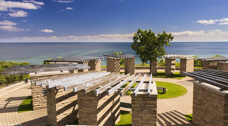
#### 2) Veterans’ Point Gardens (Harwood Ave. S.)
A landscaped memorial park with interpretation panels linking Ajax’s WWII history to HMS Ajax and the town’s wartime origins. It’s right on the trail and adds substance to a purely scenic walk—plan a pause to read the panels. Washrooms are available seasonally at or near this node.
#### 3) Carruthers Marsh & Pavilion (east end)
If your map or GPS brings you to 55 Ashbury Blvd (L1Z 0E7), that’s the Carruthers Marsh Pavilion—the formal facility on the east side of the Ajax Waterfront. It houses washrooms and a multi-use room; the surrounding marsh boardwalk and play spaces make it an easy family anchor point. The Town site lists the pavilion and its functions at this address.
> Heads-up on addresses: Many third-party listings say “Ajax Waterfront” generically; the precise civic address most visitors use is the pavilion at 55 Ashbury Blvd for the east side, and “Rotary Park – Lake Driveway W” for the west side. Use both if you’re ridesharing to meet friends at different ends. Lakes Waterfront Trail
—
### Beach stop: Paradise Beach (adjacent to the trail)
Paradise Beach sits along this same shoreline corridor and is historically notable (1920s cottage culture) as well as practical today (boardwalk connections, volleyball courts, picnic areas). It’s a solid side stop on a longer lakefront day—just check current water quality before you swim (more on that below). Lakes Guide
—
### Water quality & seasonal advisories (important)
– Who monitors? The Durham Region Health Department tests public beaches during the summer and posts weekly results to its site and channels. Outside the monitoring season, assume conditions are not being tested and plan accordingly.
– Where to check: The Region’s beach page and disclosure portal; community-trusted aggregators like Swim Guide also rebroadcast Durham’s postings and explain standards (E. coli thresholds and advisories). Treat Swim Guide as a convenience layer, but follow the Region’s notices first.
– What changed recently? Summer 2025 saw periodic “all clear” weeks across Durham’s Lake Ontario beaches, interspersed with standard caution weeks; do not assume a previous week’s status applies to your visit. Always re-check the current week’s posting.
> Accuracy note: Water-quality status is time-sensitive. If you’re reading this outside June–August testing windows, treat any swim claim as outdated until you confirm with Durham Region’s latest report.
—
### Accessibility & inclusivity
– Trail surface: The Ajax segment of the Waterfront Trail is paved and largely flat, which improves access for mobility devices and strollers. Several staging areas list accessible washrooms; the Town’s official trail/parks materials also map accessible facilities.
– Planning for mixed needs: Because distances between amenities can be a couple of kilometres, consider staging at Rotary Park or Carruthers Marsh if your group needs predictable washroom access or shorter out-and-back loops.
—
### Practical route planning (parking, transit, timing)
– Parking & wayfinding: Rotary Park (west) and Carruthers Marsh Pavilion (east) are reliable anchors for parking and meeting up. If you’re using a pin, 55 Ashbury Blvd gets you to the east facilities; Rotary Park is signed off Lake Driveway W.
– Transit linkage: The waterfront connects to Durham Region Transit and GO Transit via Harwood Ave. and Bayly St.; if you’re arriving by train, you can connect onward by bus or roll a bike to the shoreline. (General transit linkage and trail-to-GO mapping appears in the Town’s trail resources.)
– How long to allocate: The full out-and-back between Rotary Park and the Carruthers Marsh area is an easy half-day on foot with stops; on bikes, you can cover the waterfront stretch casually in 45–90 minutes depending on photo breaks and wind. (Distance basis: ~6 km Ajax Waterfront Trail.)
—
### Activities that work well here
– Scenic walking & running: Paved surfaces, continuous lake views, and frequent benches make this an easy cardio route with built-in rest points.
– Family picnics & playground time: Rotary Park and the pavilion precinct have the amenities that make family days friction-free (washrooms, seasonal concessions, splash/play areas, picnic tables).
– Cycling & micro-adventures: The Ajax stretch sits within the broader Waterfront East cycling corridor that links Scarborough through Pickering, Ajax, Whitby, and Oshawa—use the Ajax zone as a scenic middle chapter or a warm-up ride.
– History stop: Build in 15–20 minutes at Veterans’ Point Gardens to read the interpretation panels and understand why Ajax’s identity is tied to WWII manufacturing and the Royal Navy.
—
### Safety, shoreline changes & what’s new vs. old
– Erosion & boardwalk works: The section Duffins Creek → Rotary Park underwent shoreline erosion remediation and trail realignment; the closure noted in 2020–2021 has since been resolved with a boardwalk extension. If you see older posts about closures, they’re historical. Lakes Waterfront Trail
– Road connectors: Historical notes mention a short on-road section on Bayly St. for the Ajax Waterfront Trail. If you’re cycling with kids, pre-scan your route and consider reversing direction to favour the fully off-road portions.
—
### Quick itinerary ideas
– 90-minute sampler: Park at Veterans’ Point Gardens (central), walk east toward Carruthers Marsh for boardwalk/marsh views, then return west for lakefront lookouts. Restrooms are seasonally available around both nodes. Lakes Waterfront Trail
– Half-day family plan: Stage at Rotary Park, picnic and playground time first, then a flat out-and-back toward Harwood Ave. and the gardens. If energy holds, continue east to Carruthers Marsh Pavilion before returning.
– Beach day add-on: Combine a shoreline walk with a stop at Paradise Beach when the Region’s weekly report says conditions are safe for swimming. Re-check status the morning of your visit.
—
### What’s at 55 Ashbury Blvd (the address you provided)
Your address points to the Carruthers Marsh Pavilion, an official Town facility within the Ajax Waterfront corridor. It’s a smart rendezvous spot on the east side thanks to washrooms, meeting space, and proximity to the marsh boardwalk and playgrounds.
—
## Need-to-know summary
– Three key nodes: Rotary Park (west), Veterans’ Point Gardens (central), Carruthers Marsh Pavilion (east). Plan around these for parking, facilities, and short loops. Lakes Waterfront Trail
– Distance & surface: ~6 km of mostly paved, lake-edge trail; family-friendly grades.
– Facilities: Seasonal washrooms/refreshments at Rotary Park; washrooms at Veterans’ Point Gardens and Carruthers Marsh Pavilion per trail authority/Town listings. Lakes Waterfront Trail
– Beach checks: Durham Region Health posts weekly swim advisories in season—always verify current status before getting in the water.
> Data integrity note: Third-party reviews sometimes conflate “Ajax Waterfront” with specific parks; for the exact civic facility at your address, rely on the Town’s Carruthers Marsh Pavilion listing and the Waterfront Trail’s staging-area map.
This guide was compiled using current municipal/trail authority sources and Durham Region public-health notices. Where conditions can change (water quality, seasonal hours), those items are flagged above so you can re-verify on the day you go.
Table of Contents
- Key Highlights
- Location
- Places to Stay Near Ajax Waterfront"great outdoor activities, pinic area and playground for the entire family"
- Find and Book a Tour
- Explore More Travel Guides
- Ajax Waterfront: How to Do This Lake Ontario Gem Right (Routes, Parks, Accessibility & Water-Quality Tips)
- Why the Ajax Waterfront works for a half-day or full day
- The waterfront, zone by zone
- Beach stop: Paradise Beach (adjacent to the trail)
- Water quality & seasonal advisories (important)
- Accessibility & inclusivity
- Practical route planning (parking, transit, timing)
- Activities that work well here
- Safety, shoreline changes & what’s new vs. old
- Quick itinerary ideas
- What’s at 55 Ashbury Blvd (the address you provided)
- Need-to-know summary
- Nearby Places You Might Like
- Traveler Reviews for Ajax Waterfront
- Share Your Experience
Key Highlights
Linked parks, one ribbon trail. You can move seamlessly along lakeside boardwalks and paved paths between Rotary Park, Veterans’ Point Gardens, and the Carruthers Marsh area. The Waterfront Trail authority lists all three as Ajax “staging areas,” which makes logistics simple (parking, washrooms, wayfinding). oai_citation:1‡Great Lakes Waterfront Trail
Family-ready infrastructure. Rotary Park and the eastern pavilion area concentrate seasonal washrooms, concessions, splash/play zones, and picnic space—useful if you’re mixing stroller time with long lake views. oai_citation:2‡ajax.ca
You can choose your distance. The Ajax Waterfront Trail segment is about 6 km (with a short on-road connector historically noted around Bayly St.). It’s predominantly asphalt and flat, which suits walkers, runners, and cyclists. oai_citation:3‡ontariotrails.on.ca
Location
Places to Stay Near Ajax Waterfront"great outdoor activities, pinic area and playground for the entire family"
Find and Book a Tour
Explore More Travel Guides
No reviews found! Be the first to review!
Ajax Waterfront: How to Do This Lake Ontario Gem Right (Routes, Parks, Accessibility & Water-Quality Tips)
Location: Ajax, Ontario, Canada (approx. 43.8297606, -78.9860881)
What it is: A continuous stretch of public shoreline on Lake Ontario tied together by the Great Lakes Waterfront Trail, with staging areas at Rotary Park (west), Veterans’ Point Gardens (central/Harwood Ave. S.), and Carruthers Marsh Pavilion (east). oai_citation:0‡Great Lakes Waterfront Trail
Why the Ajax Waterfront works for a half-day or full day
- Linked parks, one ribbon trail. You can move seamlessly along lakeside boardwalks and paved paths between Rotary Park, Veterans’ Point Gardens, and the Carruthers Marsh area. The Waterfront Trail authority lists all three as Ajax “staging areas,” which makes logistics simple (parking, washrooms, wayfinding). oai_citation:1‡Great Lakes Waterfront Trail
- Family-ready infrastructure. Rotary Park and the eastern pavilion area concentrate seasonal washrooms, concessions, splash/play zones, and picnic space—useful if you’re mixing stroller time with long lake views. oai_citation:2‡ajax.ca
- You can choose your distance. The Ajax Waterfront Trail segment is about 6 km (with a short on-road connector historically noted around Bayly St.). It’s predominantly asphalt and flat, which suits walkers, runners, and cyclists. oai_citation:3‡ontariotrails.on.ca
The waterfront, zone by zone
1) Rotary Park & the mouth of Duffins Creek (west end)
This is a classic start/finish point thanks to parking and seasonal amenities. The trail here offers open lake views and quick access to refreshments and washrooms inside the park area. If you’re planning a family picnic before or after a bike ride, stage here. oai_citation:4‡ontariotrails.on.ca
2) Veterans’ Point Gardens (Harwood Ave. S.)
A landscaped memorial park with interpretation panels linking Ajax’s WWII history to HMS Ajax and the town’s wartime origins. It’s right on the trail and adds substance to a purely scenic walk—plan a pause to read the panels. Washrooms are available seasonally at or near this node. oai_citation:5‡ajax.ca
3) Carruthers Marsh & Pavilion (east end)
If your map or GPS brings you to 55 Ashbury Blvd (L1Z 0E7), that’s the Carruthers Marsh Pavilion—the formal facility on the east side of the Ajax Waterfront. It houses washrooms and a multi-use room; the surrounding marsh boardwalk and play spaces make it an easy family anchor point. The Town site lists the pavilion and its functions at this address. oai_citation:6‡facilities.ajax.ca
Heads-up on addresses: Many third-party listings say “Ajax Waterfront” generically; the precise civic address most visitors use is the pavilion at 55 Ashbury Blvd for the east side, and “Rotary Park – Lake Driveway W” for the west side. Use both if you’re ridesharing to meet friends at different ends. oai_citation:7‡Great Lakes Waterfront Trail
Beach stop: Paradise Beach (adjacent to the trail)
Paradise Beach sits along this same shoreline corridor and is historically notable (1920s cottage culture) as well as practical today (boardwalk connections, volleyball courts, picnic areas). It’s a solid side stop on a longer lakefront day—just check current water quality before you swim (more on that below). oai_citation:8‡Great Lakes Guide
Water quality & seasonal advisories (important)
- Who monitors? The Durham Region Health Department tests public beaches during the summer and posts weekly results to its site and channels. Outside the monitoring season, assume conditions are not being tested and plan accordingly. oai_citation:9‡durham.ca
- Where to check: The Region’s beach page and disclosure portal; community-trusted aggregators like Swim Guide also rebroadcast Durham’s postings and explain standards (E. coli thresholds and advisories). Treat Swim Guide as a convenience layer, but follow the Region’s notices first. oai_citation:10‡durham.ca
- What changed recently? Summer 2025 saw periodic “all clear” weeks across Durham’s Lake Ontario beaches, interspersed with standard caution weeks; do not assume a previous week’s status applies to your visit. Always re-check the current week’s posting. oai_citation:11‡InSauga
Accuracy note: Water-quality status is time-sensitive. If you’re reading this outside June–August testing windows, treat any swim claim as outdated until you confirm with Durham Region’s latest report. oai_citation:12‡durham.ca
Accessibility & inclusivity
- Trail surface: The Ajax segment of the Waterfront Trail is paved and largely flat, which improves access for mobility devices and strollers. Several staging areas list accessible washrooms; the Town’s official trail/parks materials also map accessible facilities. oai_citation:13‡ontariotrails.on.ca
- Planning for mixed needs: Because distances between amenities can be a couple of kilometres, consider staging at Rotary Park or Carruthers Marsh if your group needs predictable washroom access or shorter out-and-back loops. oai_citation:14‡ontariotrails.on.ca
Practical route planning (parking, transit, timing)
- Parking & wayfinding: Rotary Park (west) and Carruthers Marsh Pavilion (east) are reliable anchors for parking and meeting up. If you’re using a pin, 55 Ashbury Blvd gets you to the east facilities; Rotary Park is signed off Lake Driveway W. oai_citation:15‡facilities.ajax.ca
- Transit linkage: The waterfront connects to Durham Region Transit and GO Transit via Harwood Ave. and Bayly St.; if you’re arriving by train, you can connect onward by bus or roll a bike to the shoreline. (General transit linkage and trail-to-GO mapping appears in the Town’s trail resources.) oai_citation:16‡ajax.ca
- How long to allocate: The full out-and-back between Rotary Park and the Carruthers Marsh area is an easy half-day on foot with stops; on bikes, you can cover the waterfront stretch casually in 45–90 minutes depending on photo breaks and wind. (Distance basis: ~6 km Ajax Waterfront Trail.) oai_citation:17‡ontariotrails.on.ca
Activities that work well here
- Scenic walking & running: Paved surfaces, continuous lake views, and frequent benches make this an easy cardio route with built-in rest points. oai_citation:18‡ontariotrails.on.ca
- Family picnics & playground time: Rotary Park and the pavilion precinct have the amenities that make family days friction-free (washrooms, seasonal concessions, splash/play areas, picnic tables). oai_citation:19‡ajax.ca
- Cycling & micro-adventures: The Ajax stretch sits within the broader Waterfront East cycling corridor that links Scarborough through Pickering, Ajax, Whitby, and Oshawa—use the Ajax zone as a scenic middle chapter or a warm-up ride. oai_citation:20‡thedriveside.com
- History stop: Build in 15–20 minutes at Veterans’ Point Gardens to read the interpretation panels and understand why Ajax’s identity is tied to WWII manufacturing and the Royal Navy. oai_citation:21‡ajax.ca
Safety, shoreline changes & what’s new vs. old
- Erosion & boardwalk works: The section Duffins Creek → Rotary Park underwent shoreline erosion remediation and trail realignment; the closure noted in 2020–2021 has since been resolved with a boardwalk extension. If you see older posts about closures, they’re historical. oai_citation:22‡Great Lakes Waterfront Trail
- Road connectors: Historical notes mention a short on-road section on Bayly St. for the Ajax Waterfront Trail. If you’re cycling with kids, pre-scan your route and consider reversing direction to favour the fully off-road portions. oai_citation:23‡ontariotrails.on.ca
Quick itinerary ideas
- 90-minute sampler: Park at Veterans’ Point Gardens (central), walk east toward Carruthers Marsh for boardwalk/marsh views, then return west for lakefront lookouts. Restrooms are seasonally available around both nodes. oai_citation:24‡Great Lakes Waterfront Trail
- Half-day family plan: Stage at Rotary Park, picnic and playground time first, then a flat out-and-back toward Harwood Ave. and the gardens. If energy holds, continue east to Carruthers Marsh Pavilion before returning. oai_citation:25‡ontariotrails.on.ca
- Beach day add-on: Combine a shoreline walk with a stop at Paradise Beach when the Region’s weekly report says conditions are safe for swimming. Re-check status the morning of your visit. oai_citation:26‡durham.ca
What’s at 55 Ashbury Blvd (the address you provided)
Your address points to the Carruthers Marsh Pavilion, an official Town facility within the Ajax Waterfront corridor. It’s a smart rendezvous spot on the east side thanks to washrooms, meeting space, and proximity to the marsh boardwalk and playgrounds. oai_citation:27‡facilities.ajax.ca
Need-to-know summary
- Three key nodes: Rotary Park (west), Veterans’ Point Gardens (central), Carruthers Marsh Pavilion (east). Plan around these for parking, facilities, and short loops. oai_citation:28‡Great Lakes Waterfront Trail
- Distance & surface: ~6 km of mostly paved, lake-edge trail; family-friendly grades. oai_citation:29‡ontariotrails.on.ca
- Facilities: Seasonal washrooms/refreshments at Rotary Park; washrooms at Veterans’ Point Gardens and Carruthers Marsh Pavilion per trail authority/Town listings. oai_citation:30‡Great Lakes Waterfront Trail
- Beach checks: Durham Region Health posts weekly swim advisories in season—always verify current status before getting in the water. oai_citation:31‡durham.ca
Data integrity note: Third-party reviews sometimes conflate “Ajax Waterfront” with specific parks; for the exact civic facility at your address, rely on the Town’s Carruthers Marsh Pavilion listing and the Waterfront Trail’s staging-area map. oai_citation:32‡facilities.ajax.ca
This guide was compiled using current municipal/trail authority sources and Durham Region public-health notices. Where conditions can change (water quality, seasonal hours), those items are flagged above so you can re-verify on the day you go.
Traveler Reviews for Ajax Waterfront
There are no reviews yet. Be the first one to write one.
Have you visited Ajax Waterfront? Help other travelers by sharing your review.
You Might Also Like
Ajax Waterfront Park
Duffins Lookout
Imagination Park
Find Accommodations Nearby
Recommended Tours & Activities
Visitor Reviews
There are no reviews yet. Be the first one to write one.
Share Your Experience
Have you visited Ajax Waterfront? Help other travelers by leaving a review.