
Morro de São Jerônimo
About Morro de São Jerônimo
Description
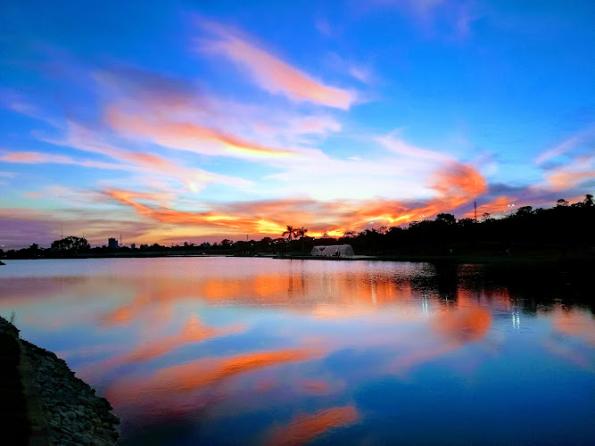
Morro de São Jerônimo stands as one of those hiking destinations that'll completely change how you think about adventure travel in Brazil. This mountain peak rises dramatically from the landscape, offering what I'd genuinely call one of the most rewarding hiking experiences you'll find anywhere in the region. The trail itself is an out-and-back route that takes you through some seriously stunning terrain - we're talking dense Atlantic Forest, rocky outcrops that make you feel tiny in the best way, and views that'll have you reaching for your camera every five minutes. What makes this place really special isn't just the destination though. It's the entire journey up. The trail challenges you in ways that feel accomplishing rather than frustrating, if that makes sense. You're climbing steadily through ecosystems that shift as you gain elevation, and every turn seems to reveal something new worth stopping for. The summit itself? Well, let's just say there's a reason hikers keep coming back here year after year. I've talked to plenty of people who've made this trek, and almost all of them describe it as genuinely transformative. There's something about earning your views through physical effort that makes them mean more, and Morro de São Jerônimo delivers on that promise in spades. The peak sits at an impressive altitude that gives you this incredible 360-degree perspective of the surrounding mountains and valleys, and on clear days you can see for what feels like forever. The mountain itself has become quite popular among serious hikers and outdoor enthusiasts, though it hasn't reached that overwhelming tourist-trap status yet. You'll find a good mix of experienced mountaineers and adventurous travelers testing their limits here. And honestly? That balance is perfect because it means the trails are maintained and respected without being overcrowded most days of the year.Key Features
- Out-and-back hiking trail that typically takes between 8-10 hours to complete round trip, depending on your fitness level and how many photo stops you make along the way
- Summit elevation that provides absolutely breathtaking panoramic views of the Serra do Mar mountain range and surrounding Atlantic Forest canopy
- Challenging terrain that includes steep ascents, rock scrambling sections, and narrow ridge walks that'll get your adrenaline going
- Rich biodiversity throughout the trail with opportunities to spot native birds, unique plant species, and if you're lucky, some of the region's more elusive wildlife
- Rocky summit area perfect for taking a well-deserved break and soaking in the accomplishment of reaching the top
- Trail conditions that vary significantly with weather, creating different experiences depending on when you visit
- Multiple viewpoints along the ascent where you can gauge your progress and catch your breath while admiring the scenery
- Natural water sources along parts of the route, though you shouldn't rely on these exclusively for hydration
- Relatively primitive trail conditions that require good navigation skills and proper preparation
- Technical sections that demand both physical endurance and mental focus, making the achievement feel that much more significant
Best Time to Visit
Timing your visit to Morro de São Jerônimo can honestly make or break your experience, so let's talk real specifics here. The dry season between May and September generally offers your best shot at clear skies and manageable trail conditions. During these months, you're looking at cooler temperatures which actually work in your favor when you're doing serious uphill hiking for hours at a time. I'd personally recommend aiming for the shoulder months of May or September if you can swing it. The weather tends to be more stable than mid-winter, and you're likely to encounter fewer hikers on the trail which means more of that peaceful mountain solitude we all crave. Plus, the temperatures during these months hover in that sweet spot where you're not freezing at the summit but also not overheating during the climb. The rainy season from November through March? Well, that's when things get tricky. Heavy rains can make the trail dangerously slippery, and those rock scrambling sections become genuinely hazardous when wet. Cloud cover during these months also tends to obscure those incredible summit views that you're working so hard to reach. But here's the thing - some experienced hikers actually prefer these conditions because the forest is incredibly lush, waterfalls are flowing strong, and there's something pretty magical about hiking through mist-covered mountains. Weekdays almost always offer a better experience than weekends, especially during peak season. You'll have more space on the trail, better photo opportunities without other people in your shots, and a more meditative hiking experience overall. Starting your hike as early as possible isn't just about avoiding crowds though - it's crucial for safety. You want to give yourself plenty of daylight hours for the descent, which can be even more challenging than going up. Weather patterns can change rapidly in mountainous areas, and Morro de São Jerônimo is no exception to this rule. Even during the dry season, afternoon clouds can roll in pretty quickly. That's why most seasoned hikers here will tell you to start your ascent at dawn or shortly after sunrise.How to Get There
Getting to Morro de São Jerônimo requires a bit of planning since this isn't exactly a walk-up-and-start-hiking kind of destination. The trailhead isn't directly accessible by public transportation, which means you'll need to sort out private transport or join an organized hiking group that includes transportation. Most travelers base themselves in nearby towns and arrange transportation from there. You're looking at driving along roads that become progressively more rural as you approach the mountain area. The final stretch to the trailhead typically involves navigating unpaved roads that can be rough depending on recent weather conditions. A vehicle with good clearance is definitely your friend here - I wouldn't attempt it in a tiny sedan after heavy rains, that's for sure. If you're coming from further away, you'll probably fly into the nearest major airport and then make ground arrangements from there. The drive to the region takes several hours, so factor that into your travel planning. Some people make this an overnight trip, camping near the trailhead or staying in local accommodations to get that early morning start. Hiring a local guide who provides transportation is actually pretty common for this hike, and honestly? It's not a bad idea at all. These guides know the route intimately, understand current trail conditions, and can handle all the logistics while you focus on the hiking itself. They'll pick you up from your accommodation, drive you to the trailhead, guide you up and down safely, and get you back to your lodging afterward. Finding the actual trailhead can be a bit confusing if you're going it alone. GPS coordinates will get you close, but the final approach might require asking locals for directions. The hiking community here is generally pretty helpful though, and you'll often find other groups heading to the same destination who can point you in the right direction.Tips for Visiting
Alright, let's get into the practical stuff that'll actually make your hike successful. First off - physical preparation matters way more than most people realize. This isn't an easy trail, and underestimating it has left many hikers exhausted halfway up with no choice but to push through or turn back disappointed. Start training at least a few weeks before your trip if you're not regularly hiking. Stair climbing, endurance cardio, and leg strengthening exercises will serve you well. Bring way more water than you think you'll need. Seriously, I can't stress this enough. The climb is strenuous, and dehydration hits hard at altitude. Most experienced hikers carry at least three liters per person, sometimes more depending on conditions. Yes, it's heavy. Yes, you'll be grateful for every drop. Pack energy-dense foods too - trail mix, energy bars, sandwiches, fruit. You'll be burning serious calories and need fuel to keep going. The weather up there can be completely different from conditions at the base, so layering is essential. Start with moisture-wicking base layers, add insulation for the summit where it can get surprisingly cold, and bring a waterproof outer layer even if the forecast looks perfect. Mountain weather does its own thing regardless of what meteorologists predict. A hat and sunscreen are non-negotiable - sun exposure at elevation is intense. Your footwear choice can literally make or break this hike. Proper hiking boots with ankle support and aggressive tread are absolutely necessary for the rocky, uneven terrain. Breaking them in before your trip isn't optional unless you enjoy painful blisters. And wear hiking socks designed to prevent friction - your feet will thank you. Navigation tools are important because trail marking can be inconsistent in some sections. Download offline maps on your phone, bring a GPS device if you have one, and don't rely solely on following others. Trails can fork unexpectedly, and you need to know where you're going. A fully charged phone plus a backup battery pack is smart thinking. Tell someone your hiking plans before you go - where you're hiking, when you expect to return, and what to do if you don't check in. This isn't being paranoid; it's being responsible. Accidents happen even to experienced hikers, and having people aware of your plans could be critically important. The trail isn't wheelchair accessible and doesn't accommodate mobility limitations, so everyone in your group needs to be capable of strenuous physical activity. Those rock scrambling sections require using your hands, maintaining balance on narrow paths, and navigating steep inclines that would be impossible for anyone with significant mobility challenges. Bathroom facilities don't exist once you leave the trailhead, so plan accordingly. Practice Leave No Trace principles religiously - pack out everything you bring in, stay on established trails, and respect the natural environment. This place remains beautiful because hikers have generally been good stewards of it. Start early - and I mean really early. Hitting the trail by 6 or 7 AM gives you ample time for the ascent, summit time, and a safe descent before darkness. Rushing down a mountain in fading light is dangerous and stressful. Build in extra time for the unexpected because something always takes longer than planned. Consider hiring a local guide, especially for your first time. Yeah, it costs more, but guides provide safety, local knowledge, and often share fascinating information about the mountain's ecology and history that you'd miss otherwise. They also know current conditions and can adjust plans if needed. Lastly, be honest with yourself about your abilities. There's no shame in turning back if conditions deteriorate or you're not feeling up to it. The mountain will still be there for another attempt, and pushing beyond your limits in remote areas can turn dangerous quickly. Summit fever is real, but staying safe matters more than reaching the top.Key Features
- Panoramic 360° summit views of Chapada dos Guimarães and Cuiabá
- Well-marked moderate trail with some rock-scramble sections
- Typical Cerrado flora and opportunities for birdwatching
- Close proximity to Cuiabá (accessible as a half-day trip)
- Cultural and historical significance tied to regional legends
More Details
Updated March 30, 2026
Table of Contents
Description
Morro de São Jerônimo stands as one of those hiking destinations that’ll completely change how you think about adventure travel in Brazil. This mountain peak rises dramatically from the landscape, offering what I’d genuinely call one of the most rewarding hiking experiences you’ll find anywhere in the region. The trail itself is an out-and-back route that takes you through some seriously stunning terrain – we’re talking dense Atlantic Forest, rocky outcrops that make you feel tiny in the best way, and views that’ll have you reaching for your camera every five minutes.
What makes this place really special isn’t just the destination though. It’s the entire journey up. The trail challenges you in ways that feel accomplishing rather than frustrating, if that makes sense. You’re climbing steadily through ecosystems that shift as you gain elevation, and every turn seems to reveal something new worth stopping for. The summit itself? Well, let’s just say there’s a reason hikers keep coming back here year after year.
I’ve talked to plenty of people who’ve made this trek, and almost all of them describe it as genuinely transformative. There’s something about earning your views through physical effort that makes them mean more, and Morro de São Jerônimo delivers on that promise in spades. The peak sits at an impressive altitude that gives you this incredible 360-degree perspective of the surrounding mountains and valleys, and on clear days you can see for what feels like forever.
The mountain itself has become quite popular among serious hikers and outdoor enthusiasts, though it hasn’t reached that overwhelming tourist-trap status yet. You’ll find a good mix of experienced mountaineers and adventurous travelers testing their limits here. And honestly? That balance is perfect because it means the trails are maintained and respected without being overcrowded most days of the year.
Key Features
- Out-and-back hiking trail that typically takes between 8-10 hours to complete round trip, depending on your fitness level and how many photo stops you make along the way
- Summit elevation that provides absolutely breathtaking panoramic views of the Serra do Mar mountain range and surrounding Atlantic Forest canopy
- Challenging terrain that includes steep ascents, rock scrambling sections, and narrow ridge walks that’ll get your adrenaline going
- Rich biodiversity throughout the trail with opportunities to spot native birds, unique plant species, and if you’re lucky, some of the region’s more elusive wildlife
- Rocky summit area perfect for taking a well-deserved break and soaking in the accomplishment of reaching the top
- Trail conditions that vary significantly with weather, creating different experiences depending on when you visit
- Multiple viewpoints along the ascent where you can gauge your progress and catch your breath while admiring the scenery
- Natural water sources along parts of the route, though you shouldn’t rely on these exclusively for hydration
- Relatively primitive trail conditions that require good navigation skills and proper preparation
- Technical sections that demand both physical endurance and mental focus, making the achievement feel that much more significant
Best Time to Visit
Timing your visit to Morro de São Jerônimo can honestly make or break your experience, so let’s talk real specifics here. The dry season between May and September generally offers your best shot at clear skies and manageable trail conditions. During these months, you’re looking at cooler temperatures which actually work in your favor when you’re doing serious uphill hiking for hours at a time.
I’d personally recommend aiming for the shoulder months of May or September if you can swing it. The weather tends to be more stable than mid-winter, and you’re likely to encounter fewer hikers on the trail which means more of that peaceful mountain solitude we all crave. Plus, the temperatures during these months hover in that sweet spot where you’re not freezing at the summit but also not overheating during the climb.
The rainy season from November through March? Well, that’s when things get tricky. Heavy rains can make the trail dangerously slippery, and those rock scrambling sections become genuinely hazardous when wet. Cloud cover during these months also tends to obscure those incredible summit views that you’re working so hard to reach. But here’s the thing – some experienced hikers actually prefer these conditions because the forest is incredibly lush, waterfalls are flowing strong, and there’s something pretty magical about hiking through mist-covered mountains.
Weekdays almost always offer a better experience than weekends, especially during peak season. You’ll have more space on the trail, better photo opportunities without other people in your shots, and a more meditative hiking experience overall. Starting your hike as early as possible isn’t just about avoiding crowds though – it’s crucial for safety. You want to give yourself plenty of daylight hours for the descent, which can be even more challenging than going up.
Weather patterns can change rapidly in mountainous areas, and Morro de São Jerônimo is no exception to this rule. Even during the dry season, afternoon clouds can roll in pretty quickly. That’s why most seasoned hikers here will tell you to start your ascent at dawn or shortly after sunrise.
How to Get There
Getting to Morro de São Jerônimo requires a bit of planning since this isn’t exactly a walk-up-and-start-hiking kind of destination. The trailhead isn’t directly accessible by public transportation, which means you’ll need to sort out private transport or join an organized hiking group that includes transportation.
Most travelers base themselves in nearby towns and arrange transportation from there. You’re looking at driving along roads that become progressively more rural as you approach the mountain area. The final stretch to the trailhead typically involves navigating unpaved roads that can be rough depending on recent weather conditions. A vehicle with good clearance is definitely your friend here – I wouldn’t attempt it in a tiny sedan after heavy rains, that’s for sure.
If you’re coming from further away, you’ll probably fly into the nearest major airport and then make ground arrangements from there. The drive to the region takes several hours, so factor that into your travel planning. Some people make this an overnight trip, camping near the trailhead or staying in local accommodations to get that early morning start.
Hiring a local guide who provides transportation is actually pretty common for this hike, and honestly? It’s not a bad idea at all. These guides know the route intimately, understand current trail conditions, and can handle all the logistics while you focus on the hiking itself. They’ll pick you up from your accommodation, drive you to the trailhead, guide you up and down safely, and get you back to your lodging afterward.
Finding the actual trailhead can be a bit confusing if you’re going it alone. GPS coordinates will get you close, but the final approach might require asking locals for directions. The hiking community here is generally pretty helpful though, and you’ll often find other groups heading to the same destination who can point you in the right direction.
Tips for Visiting
Alright, let’s get into the practical stuff that’ll actually make your hike successful. First off – physical preparation matters way more than most people realize. This isn’t an easy trail, and underestimating it has left many hikers exhausted halfway up with no choice but to push through or turn back disappointed. Start training at least a few weeks before your trip if you’re not regularly hiking. Stair climbing, endurance cardio, and leg strengthening exercises will serve you well.
Bring way more water than you think you’ll need. Seriously, I can’t stress this enough. The climb is strenuous, and dehydration hits hard at altitude. Most experienced hikers carry at least three liters per person, sometimes more depending on conditions. Yes, it’s heavy. Yes, you’ll be grateful for every drop. Pack energy-dense foods too – trail mix, energy bars, sandwiches, fruit. You’ll be burning serious calories and need fuel to keep going.
The weather up there can be completely different from conditions at the base, so layering is essential. Start with moisture-wicking base layers, add insulation for the summit where it can get surprisingly cold, and bring a waterproof outer layer even if the forecast looks perfect. Mountain weather does its own thing regardless of what meteorologists predict. A hat and sunscreen are non-negotiable – sun exposure at elevation is intense.
Your footwear choice can literally make or break this hike. Proper hiking boots with ankle support and aggressive tread are absolutely necessary for the rocky, uneven terrain. Breaking them in before your trip isn’t optional unless you enjoy painful blisters. And wear hiking socks designed to prevent friction – your feet will thank you.
Navigation tools are important because trail marking can be inconsistent in some sections. Download offline maps on your phone, bring a GPS device if you have one, and don’t rely solely on following others. Trails can fork unexpectedly, and you need to know where you’re going. A fully charged phone plus a backup battery pack is smart thinking.
Tell someone your hiking plans before you go – where you’re hiking, when you expect to return, and what to do if you don’t check in. This isn’t being paranoid; it’s being responsible. Accidents happen even to experienced hikers, and having people aware of your plans could be critically important.
The trail isn’t wheelchair accessible and doesn’t accommodate mobility limitations, so everyone in your group needs to be capable of strenuous physical activity. Those rock scrambling sections require using your hands, maintaining balance on narrow paths, and navigating steep inclines that would be impossible for anyone with significant mobility challenges.
Bathroom facilities don’t exist once you leave the trailhead, so plan accordingly. Practice Leave No Trace principles religiously – pack out everything you bring in, stay on established trails, and respect the natural environment. This place remains beautiful because hikers have generally been good stewards of it.
Start early – and I mean really early. Hitting the trail by 6 or 7 AM gives you ample time for the ascent, summit time, and a safe descent before darkness. Rushing down a mountain in fading light is dangerous and stressful. Build in extra time for the unexpected because something always takes longer than planned.
Consider hiring a local guide, especially for your first time. Yeah, it costs more, but guides provide safety, local knowledge, and often share fascinating information about the mountain’s ecology and history that you’d miss otherwise. They also know current conditions and can adjust plans if needed.
Lastly, be honest with yourself about your abilities. There’s no shame in turning back if conditions deteriorate or you’re not feeling up to it. The mountain will still be there for another attempt, and pushing beyond your limits in remote areas can turn dangerous quickly. Summit fever is real, but staying safe matters more than reaching the top.
Key Highlights
- Panoramic 360° summit views of Chapada dos Guimarães and Cuiabá
- Well-marked moderate trail with some rock-scramble sections
- Typical Cerrado flora and opportunities for birdwatching
- Close proximity to Cuiabá (accessible as a half-day trip)
- Cultural and historical significance tied to regional legends
Location
Places to Stay Near Morro de São Jerônimo
Find and Book a Tour
Explore More Travel Guides
No reviews found! Be the first to review!
Morro de São Jerônimo is a prominent Trilha de Caminhada located in Cuiabá.
Visit us at: H43M+7R – Coxipó da Ponte, Cuiabá – MT, Brazil.
Traveler Reviews for Morro de São Jerônimo
There are no reviews yet. Be the first one to write one.
Have you visited Morro de São Jerônimo? Help other travelers by sharing your review.
Nearby Attractions
You Might Also Like

Eucharistic Shrine of Our Lady of Good Dispatch
Water park

Cuiabá
Find Accommodations Nearby
Recommended Tours & Activities
Visitor Reviews
There are no reviews yet. Be the first one to write one.
Share Your Experience
Have you visited Morro de São Jerônimo? Help other travelers by leaving a review.