Alameda
About Alameda
Description
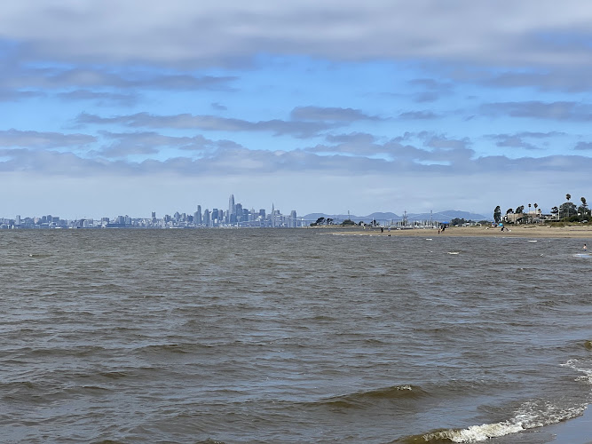
Alameda sits quietly in the San Francisco Bay, almost like it's trying to keep itself a secret from the masses flooding into nearby Oakland and San Francisco. And honestly, that's part of its charm. This island city has managed to maintain a personality that feels genuinely Californian without all the pretense you sometimes get in the Bay Area's more famous destinations. The city sprawls across what locals call an informal archipelago - basically three main islands that include Alameda Island, Bay Farm Island, and Coast Guard Island, plus a handful of smaller spots that most people don't even think about. When I first visited, I actually didn't realize I was on an island until I started looking at a map more carefully. The transitions are so smooth that you might drive right through without noticing the water surrounding you. What strikes most travelers about Alameda is how it manages to feel both connected to the pulse of the Bay Area while maintaining this distinctly residential, almost nostalgic atmosphere. The architecture tells stories - Victorian homes that have somehow survived earthquakes and modernization line streets where families actually live, not just invest. There's a realness here that's becoming harder to find in California's coastal cities. The waterfront areas offer views that'll make you stop and stare, especially during golden hour when the San Francisco skyline does that thing where it glows against the bay. But Alameda isn't just about pretty views. It's got beaches where locals actually swim, parks where kids play without helicopter parents hovering over structured activities, and a downtown that functions for residents first and Instagram second.Key Features
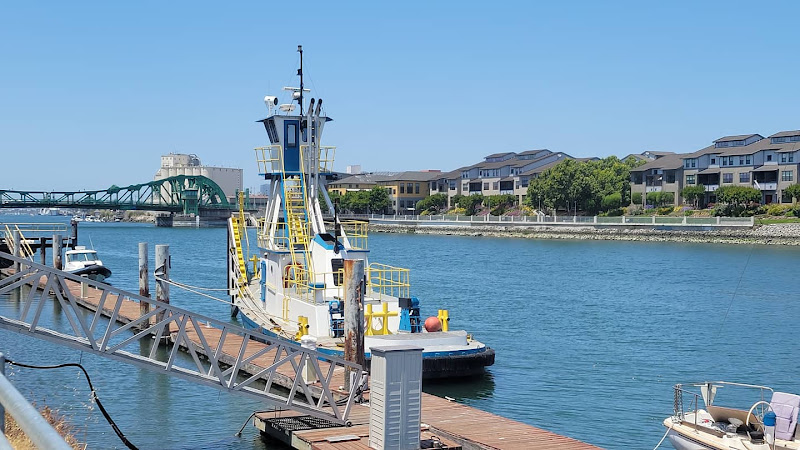
The attractions and characteristics that define Alameda create an experience quite different from typical Bay Area destinations: • Historic architecture throughout the city includes one of the highest concentrations of Victorian-era homes on the West Coast, with entire neighborhoods preserved from the late 1800s • Alameda Beach stretches along the bay with actual sand where you can swim, picnic, and watch kitesurfers doing their thing against the backdrop of San Francisco • Former Naval Air Station Alameda transforms abandoned military infrastructure into something new - think massive hangars, urban wineries, and events spaces that feel slightly post-apocalyptic in the coolest way • Park Street serves as the main drag with independently-owned shops, restaurants that locals actually eat at, and a weekly farmers market that isn't trying too hard • Crown Memorial State Beach offers three miles of shoreline perfect for walking, with calmer waters than Ocean Beach and way less fog • Shoreline bike paths connect different parts of the island, making it genuinely pleasant to explore on two wheels without risking your life in traffic • USS Hornet Museum sits permanently docked - an aircraft carrier you can actually board and explore, which recovered Apollo astronauts and served in World War II • Robert W. Crown Memorial State Beach Crab Cove Visitor Center provides educational programs about bay ecology that aren't boring even for adults • Alameda Theater & Cineplex combines Art Deco architecture with modern entertainment in a restored 1932 building • Naval architecture and maritime history permeate the city's identity, with reminders everywhere of its military and shipping pastBest Time to Visit
Alameda's weather follows typical Bay Area patterns, which means you need to throw out whatever assumptions you have about California being eternally sunny and warm. The microclimates here are real, and they matter. September through October brings what locals call the "real summer" - when the rest of the country is pulling out sweaters, Alameda finally warms up properly. These months offer the most reliable sunshine and warmest temperatures, usually in the 70s, with minimal fog. I've spent September afternoons at the beach in shorts while my friends in San Francisco were layered up three neighborhoods away. The water temperature even becomes almost tolerable for swimming, though "tolerable" is relative when we're talking about the Pacific. Spring months from March to May present another sweet spot, especially if you don't mind occasional rain. The hills across the bay turn impossibly green (yes, California has green hills, but only briefly), and the tourists haven't fully descended yet. Temperatures hover in the 60s, which is perfect for walking around and exploring without overheating. Summer - actual calendar summer from June to August - can be tricky. While it might be blazing hot inland, Alameda often stays cooler with more fog than you'd expect. But that's not necessarily bad. The fog creates moody atmospheres perfect for photography, and when it burns off by afternoon, you get spectacular clarity. Winter from November to February is the wet season, though "wet" by California standards means occasional rain, not monsoons. Temperatures rarely drop below the 40s at night or rise above the high 50s during the day. It's actually a decent time to visit if you're escaping colder climates and don't mind bringing a rain jacket. Plus, the city feels more authentically local without summer visitors. Weekdays generally provide a more authentic experience than weekends, when Bay Area residents flock to the beaches and parks. And if you're trying to catch community events, summer brings outdoor concerts and festivals that showcase local culture.How to Get There
Getting to Alameda requires a bit more planning than destinations right off a BART line, but it's not complicated once you understand the geography. Flying into the area means you'll land at either Oakland International Airport or San Francisco International Airport. Oakland sits closer - just about 15 minutes away without traffic - making it the more sensible choice for Alameda-bound travelers. San Francisco's airport puts you about 30-40 minutes away depending on traffic, which in the Bay Area can mean anything from smooth sailing to parking lot conditions. Driving to Alameda involves crossing one of several bridges or using tunnels that connect the islands to the mainland. From Oakland, you'll take either the Posey Tube or Webster Tube - underwater tunnels that feel slightly claustrophobic but get you there quickly. From the south, the Bay Farm Island Bridge provides access. The drive itself is straightforward, though rush hour traffic can be brutal on approach routes. Public transportation works but requires patience. AC Transit operates bus lines connecting Alameda to BART stations in Oakland and other East Bay locations. The system functions reliably, though schedules can be infrequent outside peak hours. Many visitors find it easier to take BART to Oakland's 12th Street Station, then catch a bus across to Alameda. Ferry service from San Francisco offers the most scenic route - the Alameda/Oakland Ferry departs from the Ferry Building and lands right in Alameda. The ride takes about 20 minutes and provides incredible views of the bay. There's something special about arriving by water that cars and buses just can't match. Once you're on the island, getting around works best with a car or bike. The city is relatively flat, making cycling pleasant, and bike rental shops near the beach cater to visitors. Some areas are walkable, particularly around Park Street downtown, but covering the whole island on foot would be exhausting. Rideshare services like Uber and Lyft operate throughout Alameda, though availability can be spotty during early mornings or late nights compared to San Francisco or Oakland.Tips for Visiting
Alameda doesn't require extensive preparation, but knowing a few things beforehand makes your visit smoother and more enjoyable. Dress in layers - this isn't optional Bay Area advice, it's mandatory. You might start your morning in fog needing a jacket and end your afternoon in sunshine wishing you'd worn shorts. The temperature can literally swing 20 degrees between different parts of the same day. Locals call it the "microclimate experience," which is a fancy way of saying the weather can't make up its mind. Parking around Park Street and beach areas gets competitive on weekends. Arrive early or be prepared to circle a bit. Most street parking is free or cheap compared to San Francisco, so don't stress too much, just build in extra time. And read the signs carefully - some areas have weird restrictions that'll get you ticketed. The food scene deserves attention beyond typical tourist guidebook recommendations. Alameda has a surprising number of family-owned restaurants representing different cuisines, particularly along Park Street and Webster Street. Don't just default to chains - the local spots offer better food and better value. Strike up conversations with residents about their favorites; people here are generally friendly and happy to share recommendations. Beach visits require realistic expectations about water temperature. Even during "warm" months, the bay water stays pretty cold - we're talking mid-60s at best. Bring a wetsuit if you actually plan to swim, or be prepared for a bracing experience. The beaches are great for walking, picnicking, and watching others brave the water. Exploring the former Naval Air Station provides a glimpse into Alameda's ongoing transformation. Some areas are open to the public for events, tours, and businesses, while others remain restricted. Check ahead about access and events - weekend markets, wine tastings at urban wineries, and special tours happen regularly but not always predictably. Bike safety matters here despite the flat terrain. Some streets lack dedicated bike lanes, and drivers aren't always as aware as they should be. Stick to designated bike paths along the shoreline when possible - they're safer and more scenic anyway. The USS Hornet Museum deserves at least two hours if you're interested in military or aviation history. The ship is massive, and you can easily spend half a day exploring if you read all the exhibits and watch the videos. It's also supposedly haunted, which adds an interesting dimension for believers in that sort of thing. Timing your visit around low tide opens up more beach area for walking and exploring tide pools at Crown Beach. Check tide schedules if beach time is a priority - the difference between high and low tide dramatically changes the shoreline experience. Bring cash for the farmers market and some smaller shops. While most places accept cards, a few holdouts prefer cash, and having some on hand avoids awkward situations. Photography enthusiasts should plan for morning shoots along the waterfront when the light hits the San Francisco skyline beautifully, or sunset shots from the beach with the Bay Bridge in frame. The golden hour here delivers consistently stunning conditions when fog cooperates. Don't rush through Alameda trying to check boxes on an itinerary. The city rewards slowing down, wandering residential streets to admire architecture, sitting on benches watching bay life, and generally not treating it like a theme park. This is a real city where people live real lives, and that authenticity is exactly what makes it worth visiting.Key Features
- Historic Victorian and Craftsman architecture
- Park Street dining, shops and cafes
- Beaches and bayfront views with sunsets
- Naval and aviation heritage sites
- Frequent local festivals and community events
More Details
Updated January 16, 2026
Table of Contents
- Description
- Key Features
- Best Time to Visit
- How to Get There
- Tips for Visiting
- Key Highlights
- Location
- Places to Stay Near Alameda
- Find and Book a Tour
- Explore More Travel Guides
- Alameda da Tertúlia, Porto Velho (RO): what it is, where it sits, and how to plan a quick stop
- Why this place shows up on maps
- Exact location you can trust
- What to combine it with (high-value nearby stops)
- Practical planning (climate, timing, mobility)
- Getting there & micro-navigation
- What you’ll actually do here (manage expectations)
- Frequently asked (and answerable with sources)
- Inclusive, factual, and up-to-date notes
- Map pin & copy-paste essentials
- Traveler Reviews for Alameda
- Share Your Experience
Description
Alameda sits quietly in the San Francisco Bay, almost like it’s trying to keep itself a secret from the masses flooding into nearby Oakland and San Francisco. And honestly, that’s part of its charm. This island city has managed to maintain a personality that feels genuinely Californian without all the pretense you sometimes get in the Bay Area’s more famous destinations.
The city sprawls across what locals call an informal archipelago – basically three main islands that include Alameda Island, Bay Farm Island, and Coast Guard Island, plus a handful of smaller spots that most people don’t even think about. When I first visited, I actually didn’t realize I was on an island until I started looking at a map more carefully. The transitions are so smooth that you might drive right through without noticing the water surrounding you.
What strikes most travelers about Alameda is how it manages to feel both connected to the pulse of the Bay Area while maintaining this distinctly residential, almost nostalgic atmosphere. The architecture tells stories – Victorian homes that have somehow survived earthquakes and modernization line streets where families actually live, not just invest. There’s a realness here that’s becoming harder to find in California’s coastal cities.
The waterfront areas offer views that’ll make you stop and stare, especially during golden hour when the San Francisco skyline does that thing where it glows against the bay. But Alameda isn’t just about pretty views. It’s got beaches where locals actually swim, parks where kids play without helicopter parents hovering over structured activities, and a downtown that functions for residents first and Instagram second.
Key Features
The attractions and characteristics that define Alameda create an experience quite different from typical Bay Area destinations:
• Historic architecture throughout the city includes one of the highest concentrations of Victorian-era homes on the West Coast, with entire neighborhoods preserved from the late 1800s
• Alameda Beach stretches along the bay with actual sand where you can swim, picnic, and watch kitesurfers doing their thing against the backdrop of San Francisco
• Former Naval Air Station Alameda transforms abandoned military infrastructure into something new – think massive hangars, urban wineries, and events spaces that feel slightly post-apocalyptic in the coolest way
• Park Street serves as the main drag with independently-owned shops, restaurants that locals actually eat at, and a weekly farmers market that isn’t trying too hard
• Crown Memorial State Beach offers three miles of shoreline perfect for walking, with calmer waters than Ocean Beach and way less fog
• Shoreline bike paths connect different parts of the island, making it genuinely pleasant to explore on two wheels without risking your life in traffic
• USS Hornet Museum sits permanently docked – an aircraft carrier you can actually board and explore, which recovered Apollo astronauts and served in World War II
• Robert W. Crown Memorial State Beach Crab Cove Visitor Center provides educational programs about bay ecology that aren’t boring even for adults
• Alameda Theater & Cineplex combines Art Deco architecture with modern entertainment in a restored 1932 building
• Naval architecture and maritime history permeate the city’s identity, with reminders everywhere of its military and shipping past
Best Time to Visit
Alameda’s weather follows typical Bay Area patterns, which means you need to throw out whatever assumptions you have about California being eternally sunny and warm. The microclimates here are real, and they matter.
September through October brings what locals call the “real summer” – when the rest of the country is pulling out sweaters, Alameda finally warms up properly. These months offer the most reliable sunshine and warmest temperatures, usually in the 70s, with minimal fog. I’ve spent September afternoons at the beach in shorts while my friends in San Francisco were layered up three neighborhoods away. The water temperature even becomes almost tolerable for swimming, though “tolerable” is relative when we’re talking about the Pacific.
Spring months from March to May present another sweet spot, especially if you don’t mind occasional rain. The hills across the bay turn impossibly green (yes, California has green hills, but only briefly), and the tourists haven’t fully descended yet. Temperatures hover in the 60s, which is perfect for walking around and exploring without overheating.
Summer – actual calendar summer from June to August – can be tricky. While it might be blazing hot inland, Alameda often stays cooler with more fog than you’d expect. But that’s not necessarily bad. The fog creates moody atmospheres perfect for photography, and when it burns off by afternoon, you get spectacular clarity.
Winter from November to February is the wet season, though “wet” by California standards means occasional rain, not monsoons. Temperatures rarely drop below the 40s at night or rise above the high 50s during the day. It’s actually a decent time to visit if you’re escaping colder climates and don’t mind bringing a rain jacket. Plus, the city feels more authentically local without summer visitors.
Weekdays generally provide a more authentic experience than weekends, when Bay Area residents flock to the beaches and parks. And if you’re trying to catch community events, summer brings outdoor concerts and festivals that showcase local culture.
How to Get There
Getting to Alameda requires a bit more planning than destinations right off a BART line, but it’s not complicated once you understand the geography.
Flying into the area means you’ll land at either Oakland International Airport or San Francisco International Airport. Oakland sits closer – just about 15 minutes away without traffic – making it the more sensible choice for Alameda-bound travelers. San Francisco’s airport puts you about 30-40 minutes away depending on traffic, which in the Bay Area can mean anything from smooth sailing to parking lot conditions.
Driving to Alameda involves crossing one of several bridges or using tunnels that connect the islands to the mainland. From Oakland, you’ll take either the Posey Tube or Webster Tube – underwater tunnels that feel slightly claustrophobic but get you there quickly. From the south, the Bay Farm Island Bridge provides access. The drive itself is straightforward, though rush hour traffic can be brutal on approach routes.
Public transportation works but requires patience. AC Transit operates bus lines connecting Alameda to BART stations in Oakland and other East Bay locations. The system functions reliably, though schedules can be infrequent outside peak hours. Many visitors find it easier to take BART to Oakland’s 12th Street Station, then catch a bus across to Alameda.
Ferry service from San Francisco offers the most scenic route – the Alameda/Oakland Ferry departs from the Ferry Building and lands right in Alameda. The ride takes about 20 minutes and provides incredible views of the bay. There’s something special about arriving by water that cars and buses just can’t match.
Once you’re on the island, getting around works best with a car or bike. The city is relatively flat, making cycling pleasant, and bike rental shops near the beach cater to visitors. Some areas are walkable, particularly around Park Street downtown, but covering the whole island on foot would be exhausting.
Rideshare services like Uber and Lyft operate throughout Alameda, though availability can be spotty during early mornings or late nights compared to San Francisco or Oakland.
Tips for Visiting
Alameda doesn’t require extensive preparation, but knowing a few things beforehand makes your visit smoother and more enjoyable.
Dress in layers – this isn’t optional Bay Area advice, it’s mandatory. You might start your morning in fog needing a jacket and end your afternoon in sunshine wishing you’d worn shorts. The temperature can literally swing 20 degrees between different parts of the same day. Locals call it the “microclimate experience,” which is a fancy way of saying the weather can’t make up its mind.
Parking around Park Street and beach areas gets competitive on weekends. Arrive early or be prepared to circle a bit. Most street parking is free or cheap compared to San Francisco, so don’t stress too much, just build in extra time. And read the signs carefully – some areas have weird restrictions that’ll get you ticketed.
The food scene deserves attention beyond typical tourist guidebook recommendations. Alameda has a surprising number of family-owned restaurants representing different cuisines, particularly along Park Street and Webster Street. Don’t just default to chains – the local spots offer better food and better value. Strike up conversations with residents about their favorites; people here are generally friendly and happy to share recommendations.
Beach visits require realistic expectations about water temperature. Even during “warm” months, the bay water stays pretty cold – we’re talking mid-60s at best. Bring a wetsuit if you actually plan to swim, or be prepared for a bracing experience. The beaches are great for walking, picnicking, and watching others brave the water.
Exploring the former Naval Air Station provides a glimpse into Alameda’s ongoing transformation. Some areas are open to the public for events, tours, and businesses, while others remain restricted. Check ahead about access and events – weekend markets, wine tastings at urban wineries, and special tours happen regularly but not always predictably.
Bike safety matters here despite the flat terrain. Some streets lack dedicated bike lanes, and drivers aren’t always as aware as they should be. Stick to designated bike paths along the shoreline when possible – they’re safer and more scenic anyway.
The USS Hornet Museum deserves at least two hours if you’re interested in military or aviation history. The ship is massive, and you can easily spend half a day exploring if you read all the exhibits and watch the videos. It’s also supposedly haunted, which adds an interesting dimension for believers in that sort of thing.
Timing your visit around low tide opens up more beach area for walking and exploring tide pools at Crown Beach. Check tide schedules if beach time is a priority – the difference between high and low tide dramatically changes the shoreline experience.
Bring cash for the farmers market and some smaller shops. While most places accept cards, a few holdouts prefer cash, and having some on hand avoids awkward situations.
Photography enthusiasts should plan for morning shoots along the waterfront when the light hits the San Francisco skyline beautifully, or sunset shots from the beach with the Bay Bridge in frame. The golden hour here delivers consistently stunning conditions when fog cooperates.
Don’t rush through Alameda trying to check boxes on an itinerary. The city rewards slowing down, wandering residential streets to admire architecture, sitting on benches watching bay life, and generally not treating it like a theme park. This is a real city where people live real lives, and that authenticity is exactly what makes it worth visiting.
Key Highlights
- Historic Victorian and Craftsman architecture
- Park Street dining, shops and cafes
- Beaches and bayfront views with sunsets
- Naval and aviation heritage sites
- Frequent local festivals and community events
Location
Places to Stay Near Alameda
Find and Book a Tour
Explore More Travel Guides
No reviews found! Be the first to review!
Alameda da Tertúlia, Porto Velho (RO): what it is, where it sits, and how to plan a quick stop
Short version: Alameda da Tertúlia is listed locally as a ponto turístico (tourist sight) in Porto Velho. It’s tied to the Arigolândia waterfront just off the Rio Madeira and is easy to pinpoint at R. Senador Álvaro Maia, 182 – Arigolândia, CEP 76801-194. Expect a simple urban stop—useful as a waypoint on a Rio Madeira stroll, for photos, or as a meet-up before/after a meal on the orla (riverfront). Always verify opening details on arrival; online listings don’t publish hours. oai_citation:0‡Bendito Guia
Why this place shows up on maps
- Recognized listing: Several travel and local directory sites index Alameda da Tertúlia as an attraction with the exact address above. That gives you a firm geo-reference even if on-site signage is modest. oai_citation:1‡Bendito Guia
- Arigolândia context: The street runs through Arigolândia, a waterfront neighborhood historically associated with migrants known as “arigós” during World War II. The district borders the Rio Madeira and abuts Porto Velho’s central areas—handy for walking the river edge and hopping to downtown symbols. oai_citation:2‡geoportal.portovelho.ro.gov.br
Exact location you can trust
- Address: R. Sen. Álvaro Maia, 182 – Arigolândia, Porto Velho – RO, 76801-194. Brazil’s CEP databases confirm that numbering and CEP range on this street segment. oai_citation:3‡Rua CEP
- Coordinates (from your brief): –8.7568406, –63.9128986. If you copy/paste those into your map app, you’ll land on the right block.
- Nearby landmark to orient yourself: Orla 158 Cozinha (Rua Sen. Álvaro Maia, 158) is on the same street and widely referenced on restaurant platforms and social posts—helpful when giving a driver a recognizable anchor. oai_citation:4‡Tripadvisor
Hours & services: No official hours are published for Alameda da Tertúlia itself; treat it as a public-realm stop that you visit in daylight. Listings advise confirming specifics directly on site. oai_citation:5‡trip.com
What to combine it with (high-value nearby stops)
- Praça das Três Caixas d’Água (the “Três Marias”): Porto Velho’s steel water-tower trio—an official city symbol and historic memorial to the Madeira-Mamoré Railway—sits barely a few minutes away by car. If you’re photo-driven or mapping a short city loop, put this next on your list. oai_citation:6‡Prefeitura de Porto Velho
- Arigolândia waterfront (orla) walk: Use the riverfront restaurants and belvederes along Rua Sen. Álvaro Maia as staging points to see the Rio Madeira from ground level. Social and venue posts consistently highlight the river views from this stretch. oai_citation:7‡Tripadvisor
- “Rota dos Arigós” (heritage thread): The municipal tourism office maps a route through Arigolândia that threads together early civic buildings and sites tied to migrant history. If you enjoy context with your strolls, reading their notes before you go adds meaning to what you’re seeing. oai_citation:8‡Prefeitura de Porto Velho
Practical planning (climate, timing, mobility)
- Seasonality that actually affects your walk: Porto Velho has a pronounced wet season (roughly Oct–Apr) and a drier stretch centered on Jun–Aug (May/Sep are transitional). Downpours in peak months are real; plan daylight visits and carry rain protection. oai_citation:9‡climatestotravel.com
- River level caveat: The Rio Madeira can swing dramatically with rainfall. In recent seasons, navigation and riverfront activity across the Amazon system have been affected by unusually low levels; if you’re eyeing any boat add-ons before/after your stop, check local conditions the same week you visit. oai_citation:10‡Reuters
- Accessibility & safety basics: This is standard urban pavement near the orla. Expect uneven surfaces in places and limited shade at midday. As with any riverfront city walk in Brazil, keep valuables discreet and prioritize daytime.
- By car/app: Put “R. Senador Álvaro Maia, 182 – Arigolândia” in your ride app. If that doesn’t resolve, use “R. Senador Álvaro Maia, 158” (Orla 158) and walk one short block. oai_citation:11‡Tripadvisor
- On foot: From central Porto Velho, it’s a short walk downhill toward the water. Arigolândia borders Centro and Caiari; the city’s geo-portal confirms those neighborhood limits and the river edge. oai_citation:12‡geoportal.portovelho.ro.gov.br
What you’ll actually do here (manage expectations)
- Think of it as a waypoint on the riverfront: Take a few photos, orient yourself to the Rio Madeira, and then continue along the street to food & drink stops with views. That’s the strongest use of the spot given how it’s indexed and where it sits. oai_citation:13‡Bendito Guia
- Pair it with a signature city icon: After your orla time, jump to Três Caixas d’Água for a quick history hit and skyline-style photos—this pairing neatly covers “waterfront + city symbol” in under two hours. oai_citation:14‡Prefeitura de Porto Velho
Frequently asked (and answerable with sources)
-
Is “Alameda da Tertúlia” a museum or paid attraction?
There’s no evidence it’s a ticketed venue; it appears in directories as a mapped point/attraction with a standard civic address. Verify any special programming on the ground. oai_citation:15‡Bendito Guia -
Is the address accurate?
Yes. Multiple independent sources confirm R. Sen. Álvaro Maia, 182 – Arigolândia – 76801-194 within the correct CEP range for that street segment. oai_citation:16‡Rua CEP -
What’s interesting about the street name?
Rua Senador Álvaro Maia honors Álvaro Botelho Maia, a journalist and politician with Amazonian ties; he even served as an interim superintendent (mayor) of Porto Velho in the 1920s. oai_citation:17‡pt.wikipedia.org
Inclusive, factual, and up-to-date notes
- Hours & facilities: Not published; treat as public space. Some nearby venues publish daily hours (useful for restrooms or shade), but those belong to the venues themselves, not to Alameda da Tertúlia. oai_citation:18‡Tripadvisor
- Recent climate anomalies: Amazon-basin river levels have shown atypical lows in recent dry seasons; keep expectations flexible if your plan involves river transport the same day. oai_citation:19‡Reuters
Map pin & copy-paste essentials
- Address: R. Sen. Álvaro Maia, 182 – Arigolândia, Porto Velho – RO, 76801-194, Brazil. oai_citation:20‡Bendito Guia
- Neighborhood: Arigolândia (west-side, river-adjacent). oai_citation:21‡geoportal.portovelho.ro.gov.br
- Nearby anchor for drivers: Orla 158 Cozinha, Rua Sen. Álvaro Maia, 158. oai_citation:22‡Tripadvisor
If you’d like, I can add a printable walking loop that stitches Alameda da Tertúlia → waterfront cafés → Três Caixas d’Água, with distances and a daylight-only route.
Traveler Reviews for Alameda
There are no reviews yet. Be the first one to write one.
Have you visited Alameda? Help other travelers by sharing your review.
Nearby Attractions
You Might Also Like
Alameda Beach

The Meyers House and Garden
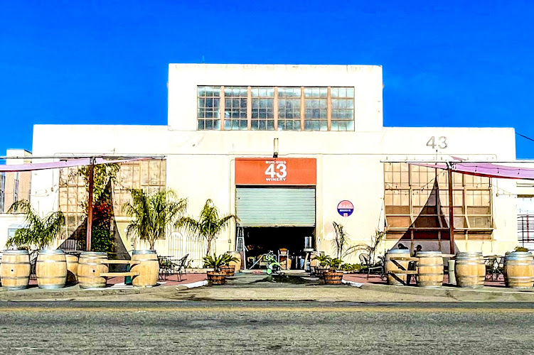
Building 43 Winery
Find Accommodations Nearby
Recommended Tours & Activities
Visitor Reviews
There are no reviews yet. Be the first one to write one.
Share Your Experience
Have you visited Alameda? Help other travelers by leaving a review.