Digo’s Hills
“`html
Table of Contents
Description
Digo’s Hills in Verdivia Trail, located within the municipality of Doña Remedios Trinidad in Bulacan, Philippines, is an underrated gem that continues to gain attention from outdoor travelers searching for raw beauty, silence, and nature’s unfiltered form. The province of Bulacan is often associated with historical sites and heritage towns, but this area holds a completely different appeal—it’s about escaping city noise and trading it for birdsong, mist, and wide-open skies.
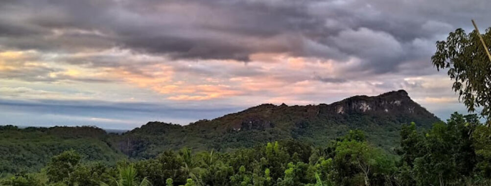
The hills roll gently between the upland barangays of the municipality, part of the Sierra Madre mountain range that stretches across Central Luzon. The atmosphere here feels refreshingly pure, especially early in the morning when the clouds hang low, forming soft veils that blend with the rough green terrain. For many travelers, this hillscape is their first real adventure outside of city life—a short but meaningful connection with the Philippine wilderness that lies only a few hours north of Manila.
The site has earned mixed reviews over the years, and honestly, that’s fair. The view is consistently stunning, yet access requires a sense of adventure and a bit of endurance. One may encounter challenging road conditions especially after rain, but for those who’ve made it, that’s exactly where the magic starts. It’s not a polished, manicured park—it’s the kind of place where imperfection defines authenticity. And that’s what makes it attractive to people who crave real outdoor experiences rather than curated ones.
From atop the main viewing area, you get a panoramic sweep of rolling terrain, dotted with patches of forest preserved through local conservation efforts. Every peak uncovers new hues of green, and when sunlight cuts through the morning mist, it paints everything gold for a few breathtaking minutes. It’s one of those fleeting sights that remind you why raw nature never goes out of style.
Key Features
- Expansive views of the Sierra Madre mountain range unfolding across Doña Remedios Trinidad, Bulacan.
- Cool morning climate ideal for hiking and photography.
- Accessible via the Verdivia Trail, known for scenic ridges and grassland paths.
- Opportunities for camping under a canopy of stars, far from light pollution.
- Close proximity to the Angat watershed forest area, ensuring fresh air and thriving flora.
- Regular visits from local guides and conservation groups promoting eco-friendly tourism.
- Perfect vantage for drone shots or sunrise treks for content creators and landscape enthusiasts.
- Varied terrain suited for beginner hikers as well as seasoned adventurers.
There’s something about Digo’s Hills that feels both rugged and gentle at once. The slopes are wide enough for casual climbs, yet they hide steep pockets that demand balance and mindfulness. For solo travelers like me who’ve trekked its paths, that unpredictability is what keeps the heart racing. There are moments when the ground suddenly evens out, revealing an unobstructed view of faraway ridges—those pauses are perfect for catching your breath and, maybe, reflecting on life’s pace.
Best Time to Visit
Generally speaking, the best time to visit is from December to early May, when the weather across Central Luzon transitions into the dry season. These months bring clearer skies, cooler mornings, and less chance of muddy trails. Visit too close to the peak of the wet season, say August or September, and you might find the roads more difficult to pass. Then again, if you don’t mind a bit of mud and dramatic clouds, the rainy months can reward you with vibrant landscapes and misty postcard-like hill shots.
Sunrise rewards early risers spectacularly—it’s when the colors burst into soft pinks and golds, sometimes mirrored by morning dew on the grass. Late afternoon, around 4 to 5 PM, is also remarkable, especially for those chasing that mellow sunset light. Personally, I’d skip noon treks—the heat can be brutal, and without shade, it becomes a test of endurance rather than leisure.
How to Get There
Reaching Digo’s Hills from Metro Manila typically takes around three hours by car, depending on traffic and weather. Travelers drive north via the North Luzon Expressway, exit at Balagtas or Bocaue, and continue through the provincial roads leading toward the municipality of Doña Remedios Trinidad. The route weaves past San Rafael and Norzagaray, offering plenty of chances to stop for snacks or gas. The final stretch can get bumpy—unpaved roads and steep inclines are common—but if you’ve done countryside drives before, it’s manageable.
Public transportation exists, though it requires a bit of patience. Jeepneys and vans travel up to certain barangays, after which local motorcycle or “habal-habal” rides take you the rest of the way. If you’re going in groups, renting a private van is smart—cheaper when shared, and it lets you control your schedule. I remember taking the backseat on one of those rough, winding roads once; the driver laughed every time I grabbed the seat handle like a city slicker not used to the hills.
Whether you choose a guided group or go solo, make sure to bring proper gear and plan your timings. Many locals suggest starting early in the morning so you can return before nightfall when the roads become harder to navigate.
Tips for Visiting
Exploring Digo’s Hills is most fulfilling when you go prepared—not overpacked, but ready for both sun and drizzle. Below are a few friendly tips from those who’ve walked the Verdivia Trail more than once.
- Start early. The sunrise view is worth the pre-dawn wake-up. Plus, the air feels crisper and roads are clearer at that hour.
- Bring enough water and snacks. There aren’t many stores once you reach the trail area, so hydration is key.
- Wear proper footwear. A good pair of hiking sandals or shoes makes all the difference on uneven paths.
- Respect local communities. Greet residents politely and avoid leaving trash behind. It’s their home after all.
- Travel light. Heavy packs slow you down. Just pack essentials—a small towel, cap, sunblock, insect repellent, and rain cover, if needed.
- Keep your gadgets secured. The wind at higher peaks can be tricky, and phones or drones can easily slip away if you’re careless.
- Be mindful of weather changes. Clouds can roll in fast, especially around the Angat watershed area. A little flexibility in your itinerary helps.
And I’ll say this from experience: the best trips here happen when you simply let the day unfold. The hills don’t function on tight agendas. There was one visit when my group planned a fixed timeline for photos and lunch stops—everything got thrown off by sudden drizzle. But instead of frustration, we ended up having a memorable chat with a local farmer who shared stories about the place’s history. That’s the thing about trips like this—you don’t just travel across kilometers of land, you meet stories that remind you how broad and warm the Filipino countryside truly is.
If you’re looking for peace, or maybe just a quick way to remind yourself that life can be more than screens and deadlines, Digo’s Hills will do wonders. Every slope tells a story, every breeze carries silence that city dwellers have long forgotten. And sometimes, all it takes to appreciate that is showing up with an open heart and good shoes.
“`
Location
Places to Stay Near Digo's Hills
Find and Book a Tour
Explore More Travel Guides
No reviews found! Be the first to review!