Parc Natural Comunal de les Valls del Comapedrosa
Table of Contents
Description
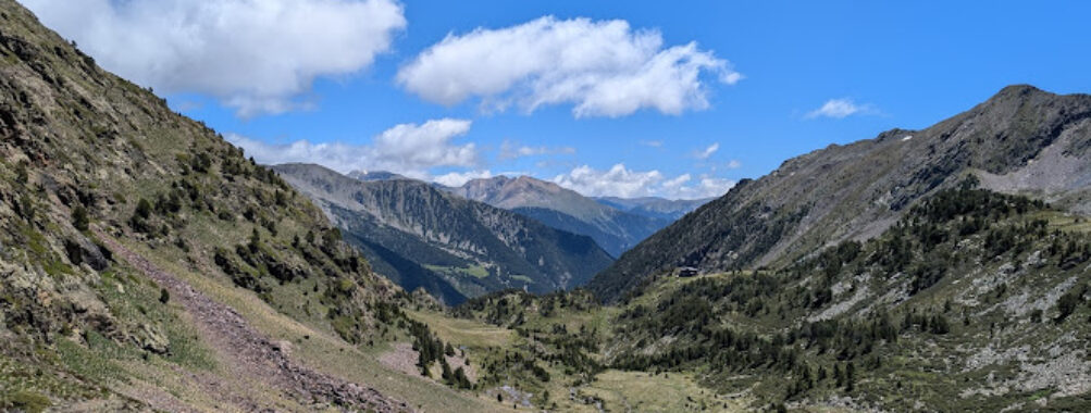
Parc Natural Comunal de les Valls del Comapedrosa is where Andorra turns the volume up on high-mountain drama and then hands visitors a well-marked path into it. Sitting in the parish of La Massana on the western edge of the country, the park protects a compact yet wild slice of the Pyrenees that climbs from thick black pine forest to rocky cirques and windswept ridgelines. This is Andorra’s highest ground, literally. The Comapedrosa peak (also known as Coma Pedrosa), at 2,942 meters, is the country’s highest point, and it presides over the park’s amphitheater of valleys, glacial lakes, and waterfalls like a granite lighthouse for hikers.
Heard of Arinsal? That’s the mountain village most travelers use as their gateway. From here the trails fan out—some gentle enough for curious kids to follow along a stream, others marching straight for the sky. The terrain is diverse for a relatively small protected area, roughly over 1,500 hectares. One minute the path is cushioned by pine needles in a shady forest; the next, it hops across slate and granite steps as the altitude climbs. Up high, summer meadows burst with alpine flowers, while late-season hikers often find snow clinging to north-facing gullies long after the calendar says it should be gone.
For nature lovers, this place is a treat. Glacial lakes like Estany de les Truites and the dark, moody Estany Negre reflect the serrated skyline and make superb picnic targets. Streams and freshwater springs stitch the valleys together, feeding wetlands and peatlands significant enough to be recognized under the Ramsar Convention for their ecological value. The park is a protected area for good reason: biodiversity. Expect to spot chamois at dawn if luck’s on your side, nimble as ghosts on the scree. Marmots whistle from the slopes in summer. Overhead, large raptors ride thermals; on still days you might hear the slow whoosh of wings before you find them with your eyes. And yes, the flora is rich too—rhododendron patches, gentians in electric blue, and the hardy black pine (Pinus uncinata) that defines much of the subalpine forest here.
As for the hiking, there’s a clear, well-kept network of trails. Waymarks are mostly consistent (look for painted blazes and posts), though a junction or two may make you slow down and check your map. That’s part of the mountain experience—moving with intention. Some routes pass mountain refuges, including Refugi del Comapedrosa, a classic spot to catch your breath, refuel, and soak in the silence that falls between conversations of hikers from across Europe. Families will appreciate that not every walk is an epic: short riverside paths near Arinsal make for easy outings with kids, and there are moderate hikes to lake viewpoints that reward without overwhelming younger legs.
It’s not all rosy. This is genuine high mountain. Trails can be steep, rocky, and slippery after rain. Shade is limited once you break the treeline, and summer storms sometimes appear like a magician’s trick in the afternoon. There are limited facilities once you leave the valley, and the lower trailheads are not designed with wheelchair accessibility in mind. On peak summer weekends, popular routes do get busy, and parking in Arinsal fills fast. But if travelers start early and pick their route wisely, the park gives far more than it asks.
Two common questions come up again and again. First: how long does it take to climb Comapedrosa? For a fit hiker, the round trip from the Arinsal valley typically runs 6 to 9 hours depending on the route and pace, with just over 1,200 to 1,400 meters of elevation gain. It’s a real mountain day. And the second: what is the tallest mountain in Andorra? That would be Comapedrosa, right here in the park, proudly topping out at 2,942 meters.
Facilities are simple but thoughtful for an alpine protected space. In Arinsal, a small visitor information point serves as the park’s front desk: trail conditions, maps, route advice, and a friendly nudge toward choosing the right objective for the weather and for visitors’ fitness. Seasonal guided outings and family activities are sometimes offered in summer. Beyond that, hikers must be self-sufficient—water treatment, snacks, weatherproof layers, and a plan. Dogs are welcome on leash. The lower valley sees lots of four-legged hikers on cool mornings, and the presence of wildlife and herds means keeping control is a must.
Parc Natural Comunal de les Valls del Comapedrosa is, at its core, an invitation to slow down. Step away from duty and deadlines for a day. And earn the views the old-fashioned way: one steady foot in front of the other.
Key Features
- Andorra’s highest peak: Comapedrosa (2,942 m), the highest point in the country, offering panoramic Pyrenees views on clear days.
- Signature glacial lakes and waterfalls: Estany de les Truites near Refugi del Comapedrosa, Estany Negre, lively streams, and cascades for scenic breaks.
- Diverse hiking trails: from kid-friendly riverside paths in the Arinsal valley to full-day summit routes with 1,000+ meters of ascent.
- Protected area status: established in 2003 to safeguard alpine ecosystems, wetlands, peatlands, and numerous endemic Pyrenean species.
- Wildlife encounters: chamois in the early light, marmots in summer, and large birds of prey soaring the thermals.
- Refuges and waymarked routes: classic mountain shelters (notably Refugi del Comapedrosa) and a clear network of hiking signs and painted blazes.
- Ramsar wetlands: internationally recognized high-mountain wetlands with freshwater springs and peatlands.
- Family-friendly options: shorter, gentle routes near Arinsal with picnic meadows and river views.
- Dog-friendly: dogs allowed on leash; bring water and respect wildlife.
- Visitor information point: in Arinsal, with maps, current conditions, and seasonal guided tours.
- Photographer’s playground: sunrise and post-storm light transform the landscape; lakes reflect jagged ridges on calm days.
- Authentic alpine feel: a high-mountain park without overbuilt infrastructure, where nature sets the pace.
Best Time to Visit
For most hikers, the sweet spot is late June through September. Trails are generally snow-free, refuges operate on summer schedules, and long daylight hours favor ambitious routes. July brings carpets of wildflowers to the meadows, while late August and early September can be wonderfully stable for big objectives like the Comapedrosa summit.
Spring in the Pyrenees is a late arriver at altitude. Snow lingers, and meltwater can swell streams or leave the ground soft. If visitors are experienced with high-mountain conditions (and know their avalanche basics), late spring can be peaceful; for everyone else, it’s better to wait until early summer.
Autumn is underrated. September to early October can deliver crisp mornings, startlingly clear views, and quieter trails. Forest colors warm the valley floors, and the lakes often sit mirror-still. After mid-October, early storms become more frequent, and days shorten fast.
Winter is for seasoned mountain travelers who come prepared for snowshoeing or ski touring under local guidance and with proper avalanche awareness. The park’s personality shifts entirely—quiet, raw, and powerful. It’s beautiful, but it demands respect and a conservative approach.
Whatever the month, an early start is gold. In summer, afternoon storms are common, and dawn departures mean safer ridge time. Plus, those first hours? That’s when wildlife makes its cameo.
How to Get There
The gateway is Arinsal, in La Massana, Andorra. From Andorra la Vella, follow the main road toward La Massana and continue up-valley toward Arinsal. The drive is straightforward and scenic, with the mountains closing in as the road heads west. In Arinsal, several public car parks serve the village and the park entrance. Arrive early on summer weekends—spaces go quickly.
Prefer public transport? The L5 bus connects Andorra la Vella, La Massana, and Arinsal. Get off near the final stops in Arinsal; from there, it’s a short walk to the park information point and the start of major trails. The convenience of the bus is a real bonus for linear routes or for groups where not everyone wants to summit but everyone wants to share a meal together afterward.
Once in Arinsal, trailheads are signed. Main routes lead up to Refugi del Comapedrosa via Estany de les Truites, toward high passes and ridgelines, and along the river for gentler walks. Carry an offline map; mobile service can be spotty as soon as the valley walls rise.
Tips for Visiting
- Pick the right route: If a summit day sounds big, aim for Estany de les Truites and Refugi del Comapedrosa. It’s a satisfying moderate hike that older kids and active families often manage well. For an easy warm-up, try the valley floor paths near Arinsal along the river.
- Know the numbers: The Comapedrosa summit typically takes 6–9 hours round trip with over 1,200 meters of ascent. It’s Andorra’s highest peak—plan accordingly, start early, and turn back if the weather misbehaves.
- Weather wins: Mountain weather flips like a coin. Check the forecast, carry layers, pack a warm hat and gloves even in July, and remember that storms often build after noon in summer.
- Hydration and treatment: Streams are plentiful, but treat or filter water. A lightweight filter bottle is ideal for this park’s network of springs and streams.
- Footing matters: Trails can be rocky, especially near the summit and high passes. Wear sturdy boots with good grip. Trekking poles help on the long descent when knees start to mutter.
- Navigation: Waymarking is good, not perfect. Download an offline map, carry a paper map as backup, and pay attention at junctions.
- Facilities and accessibility: Infrastructure is intentionally limited to protect the landscape. The lower trailheads and main routes are not wheelchair-accessible, and there are few built facilities beyond the visitor point and refuges. Restrooms are mostly at the village and refuges—plan for that.
- Refuge savvy: Refugi del Comapedrosa usually operates on a seasonal schedule with simple meals and dorm-style lodging. Book ahead in peak season and bring cash for small purchases. Even if not staying, it’s a great waypoint for a hot drink and weather check.
- Dogs and wildlife: Dogs are welcome on leash. Keep them close—chamois and ground-nesting birds don’t appreciate surprise guests, and you may encounter grazing livestock with guardian dogs.
- Leave No Trace: Pack out everything, stay on established paths, and resist the urge to shortcut switchbacks. Alpine soils are fragile and slow to recover.
- Photography: Early or late light flatters the landscape. Calm mornings are best for lake reflections, and the hour after a storm passes can produce painterly skies. Bring a protective cloth for camera lenses; mountain mist is a regular character here.
- Crowd strategy: Summer weekends get busy. Aim for weekday hikes or hit the trail at dawn. The difference in quiet is remarkable, particularly at the lakes.
- Family pointers: For kiddos, make the destination a lake or waterfall and bring a small snack “treasure” to celebrate the turnaround point. Short attention spans become long legs when a trout or a cascade is on the agenda.
- Safety first: A basic first-aid kit, a headlamp, and an emergency layer weigh very little and matter a lot. Phone coverage is variable; don’t rely on it for navigation or emergencies.
- Regulations: The park is a protected area. Drones often require special permission, open fires are a no-go, and overnighting outside refuges follows strict alpine bivouac rules—check details at the visitor point before planning a night out.
- Winter and shoulder seasons: If visiting outside peak summer, consider local guides for snow or mixed conditions. Avalanche risk, icy sections, and short daylight are real factors.
- Bus bonus: The L5 bus is handy for linear hikes or for groups with varied plans. It also solves the parking crunch on busy days—always a win.
In short, Parc Natural Comunal de les Valls del Comapedrosa in La Massana, Andorra, rewards curiosity and preparation. The park’s features—Andorra’s highest peak, a network of hiking trails, glacial lakes and waterfalls, diverse flora and fauna, and Ramsar-recognized wetlands—create a strong sense of place that hikers remember long after their legs stop feeling the climb. Plan the route, carry the essentials, and carve out time simply to sit by the water and listen. That quiet? It’s why travelers come this far up the map in the first place.
Location
Places to Stay Near Parc Natural Comunal de les Valls del Comapedrosa
Find and Book a Tour
Explore More Travel Guides
No reviews found! Be the first to review!