Princess Margaret trail
Table of Contents
Description
The Princess Margaret trail is the breezy, sea-hugging pathway that stitches together Port Elizabeth, Princess Margaret Beach, and Lower Bay on Bequia, in Saint Vincent and the Grenadines. It’s not just a shortcut between beloved beaches; it’s a coastal stroll that delivers big Caribbean views in a small, walkable package. Think: almond trees for shade, a boardwalk that skims the edge of Admiralty Bay, stairs up a rocky bluff, and the kind of turquoise water that nudges even non-swimmers to roll up their shorts. Visitors come for the swim at Princess Margaret Beach and end up talking just as much about the walk that got them there.
In practical terms, the route breaks into two scenic bites. The first section begins near Port Elizabeth’s waterfront and follows the Belmont walkway toward Princess Margaret Beach—mostly flat, with handrails and pockets of shade. The second section rises at the southern end of the beach, climbing steps over the headland and dropping into Lower Bay. Most walkers cover Port Elizabeth to Princess Margaret Beach in 15–20 minutes at a dawdle (about 0.8 km), then continue another 10–15 minutes over the headland to Lower Bay (roughly 0.5 km). Expect a mild workout on the climb—call it 30–50 meters of elevation gain—with sea breezes and sweeping views for motivation.
What does it feel like? Coastal. Intimate. Occasionally salty-splashed when the tide pops over rock. On calm days the boardwalk sections are almost meditative—fishermen mending lines by the bay, kids racing along the sand, pelicans diving like they’ve been doing this for a thousand years (they have). After rain, the steps can be slick and the dirt patches a tad muddy—still very doable with decent footwear. It isn’t wheelchair accessible, and strollers will struggle on the headland, but most families are comfortable with the terrain. Dogs are welcome on leash. And yes, it’s absolutely a good route for kids who can handle a few flights of steps with a hand to hold.
There’s a slice of local history here, too. Princess Margaret Beach took its name after the Princess famously swam in these waters in the late 1950s. The coastal path people enjoy today is part community pride, part practical necessity; it links neighborhoods to beaches and keeps foot traffic near the sea rather than along the main road. If you like seeing how daily island life meets the shoreline—boats at anchor in Admiralty Bay, water taxis ferrying sun-slicked beachgoers, the scent of grilled fish from beachside kitchens—you’ll get a concentrated dose along this trail.
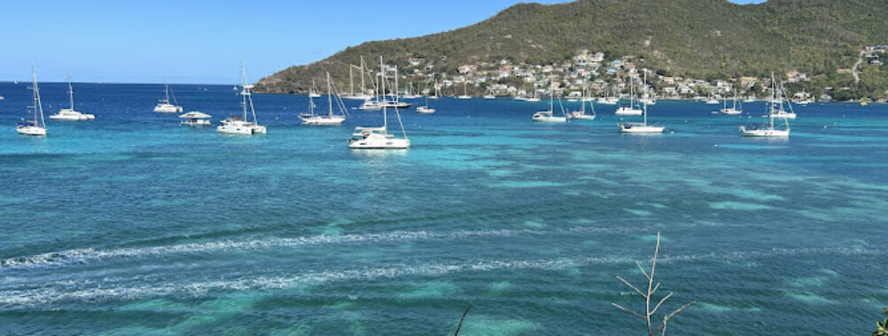
Scenery-wise, the Princess Margaret trail packs a lot into a short distance. One minute, walkers are brushing past seaside hibiscus and sea grape; the next, they’re peeking down onto a half-moon of white sand with water clear enough to count starfish. On still mornings, the Caribbean Sea is glass-flat and so transparent that snorkelers along the rocky edges seem to float above their shadows. Late afternoons turn photogenic quickly—gold light flares off the water, and the length of Admiralty Bay glows. It’s a straightforward walk, but it feels special because the landscape changes as often as you do—one corner brings a new vantage, a new shade pattern, or a sudden sighting of a turtle taking a breath near the headland.
Is Princess Margaret Beach itself worth visiting? Honestly—yes. The beach is a soft stretch of sand with sheltering trees and excellent swimming in calm conditions. There’s typically a sweet spot for snorkeling at either end near the rocks; bring a mask if you’ve got one, because the reefy nooks host parrotfish, wrasse, and the occasional hawksbill. Swimmers should keep an eye out for boat traffic closer to the moorings. As with most beaches in the Grenadines, lifeguards are not common, so sensible caution is the rule. That said, the water is usually forgiving, and the sandy entry is kind to bare feet. When swell rolls in (especially with winter north swells), conditions can get choppy; on those days, many walkers go for the views and the shade and save the swim for a calmer time.
Small note from the trail-worn: this route excels at micro-moments—ordering a cold drink, then detouring 60 seconds to a lookout to sip it while watching a sloop tack across the bay. On one late afternoon walk, the author paused at the headland steps and saw two green turtles surface in quick succession; the group behind, two kids and a granddad, went silent in that wonderful “did we all just see that?” way. Ten minutes later they were laughing about who was going to cannonball first. That’s the Princess Margaret trail: light on distance, heavy on memories.
Key Features
- Coastal connection linking Port Elizabeth, Princess Margaret Beach, and Lower Bay via a scenic trail
- Mixed terrain: boardwalk segments, stone steps, short dirt paths, and beach walking
- Short and approachable distance: roughly 1.3 km one way from town to Lower Bay
- Moderate, brief climb over the headland with rewarding views across Admiralty Bay
- Excellent photo spots: overlook points of the Caribbean Sea, moored yachts, and palm-framed bays
- Direct beach access to swim and snorkel at Princess Margaret Beach
- Shade from almond, sea grape, and palm trees along portions of the route
- Family-friendly with supervision on stairs; dogs allowed on leash
- Not wheelchair accessible; strollers find the headland section difficult
- Convenient amenities nearby: waterside cafés, beach bars, and small shops for snacks or ice cream
- Water taxi options between beaches and the Port Elizabeth waterfront
- Free to access, no permits required, and open year-round
- Connects with longer island rambles toward Friendship Bay or Mount Peggy for those seeking a bigger hike
- Safe in daylight with regular foot traffic; minimal lighting after dark
Best Time to Visit
The Princess Margaret trail is open all year, but there’s a sweet window for both weather and crowd flow. The dry season—roughly December through May—brings reliable sunshine, calmer seas, and a lower chance of rain showers. That’s ideal for this coastal walk and a swim, especially if you want those crystalline water photographs that make people back home suspicious you used a filter. Day-to-day, mornings and late afternoons are the winners. The light is gentle, temperatures are friendlier, and the bay often looks like poured glass before the breeze picks up. Midday can be bright and hot—fine if you’re prepared, but you’ll appreciate the shade breaks and a dip at the beach.
During June to November, expect warmer temperatures, a higher chance of brief downpours, and lush tropical vegetation. It’s gorgeous in a different way; rain can deepen the greens, and the trail feels extra alive. Just know that steps may be slick after a shower. Bring good footwear and give yourself a minute if you need to watch your footing—there’s no prize for racing over damp stone. Also, keep an eye on the sea state during the winter months when occasional north swells can push a bit of shore break onto the sand. On those days, consider a walk-and-watch plan: enjoy the views from the headland, then swim where conditions are calmest.
For fewer people, aim for weekdays and start before 9 am or after 3 pm. Cruise ship days can draw extra visitors to Port Elizabeth and the beaches, though the trail rarely feels congested. Sunset is lovely from the headland—gold light over Admiralty Bay with the last boats trickling home—but bring a small flashlight for the return if there’s any chance you’ll be out past dusk. There’s little in the way of trail lighting.
How to Get There
Bequia is reached by ferry from St. Vincent or by small inter-island flights; once travelers arrive in Port Elizabeth, the Princess Margaret trail is a stone’s throw from the waterfront. From the main harbor area, walkers simply follow the shoreline west along the Belmont walkway toward Princess Margaret Beach. The route runs close to the water with occasional short ramps and handrails, guiding visitors around the curve of Admiralty Bay. The entrance feels intuitive—just keep the sea on your left as you leave the harbor, and signage and foot traffic will do the rest.
For those starting at Lower Bay, taxis can drop off near the beach road. From there, the trailheads are easy to spot on the northern end of the bay—look for steps climbing the headland in the direction of Princess Margaret Beach. The ascent is short but steady. If you’re toting beach gear for a group, a simple trick is to ride to Lower Bay, claim a shady spot on the sand, and then walk the headland empty-handed for the views and a swim at Princess Margaret, coming back when ready. Alternatively, hail a water taxi to hop between the beaches and Port Elizabeth if legs or time are short.
Dinghy users and sailors can land at the small jetty by Princess Margaret Beach or use the dinghy docks around the harbor and join the path on foot. Parking for cars is limited near waterfront segments; the island’s scale and layout favor walking or quick taxi rides. For onward adventures, hikers sometimes extend the day’s route toward Friendship Bay or, for a bigger leg-stretcher, the Mount Peggy loop, which starts from the Princess Margaret/Lower Bay area and arcs across the island. It’s a different beast—hotter, steeper, longer—but it begins on the same side of the island and rewards the effort with hilltop panoramas.
Visitors asking where in the Caribbean Princess Margaret actually went get a neat history snippet here: she famously vacationed in the Grenadines and swam at the beach that now carries her name on Bequia. You’re literally walking the coastline that helped write a tiny chapter of royal-travel lore.
Tips for Visiting
Practical matters first, because they make the day better:
- Footwear: Lightweight walking shoes or sturdy sandals with grip make the headland steps and any damp sections easy. Flip-flops are fine for the beach, less ideal for the climb.
- Sun and heat: Pack reef-safe sunscreen, a hat, and at least 1 liter of water per person—more if you’re continuing to Lower Bay and lazing in the sun. The Caribbean sun doesn’t mess around.
- Swimming and snorkeling: The water at Princess Margaret Beach is generally calm with a sandy entry. Snorkel along the rocky edges for fish life; watch for boat traffic near moorings and avoid standing on coral. No lifeguards on duty.
- Timing: Mornings or late afternoons deliver cooler temps and softer light. If you’re into photography, the headland above Princess Margaret Beach is the spot—bring a lens cloth for sea spray on breezy days.
- Family and pets: The trail is good for kids with supervision on steps. Dogs are allowed; keep them leashed and carry a waste bag.
- Cash and snacks: A few small places along the waterfront sell cold drinks, bites, or a scoop of homemade ice cream. Cash is king for little purchases.
- After rain: Expect slick stone and muddy patches. Take your time on the steps. If you’ve got trekking sandals, you’ll be glad you wore them.
- Evening walks: Sunsets are spectacular, but the route is dim after dark. Carry a small flashlight or use your phone torch for the return.
- Water taxis: Handy if you want to save your legs or the kids are done walking. They’re frequent around Admiralty Bay—just ask along the beach or near the harbor.
- Respect the place: Stay on the path near private properties, pack out any trash, and choose reef-safe sunscreen to protect the marine life you came to see.
- Crowd hacks: If a cruise ship is in, start earlier or walk toward Lower Bay first. The headland views are gorgeous no matter the order.
- Longer hikes: Curious about the “longest trail near Princess Margaret Bay Beach”? The Mount Peggy circuit is your challenge route. It’s hot and steep in parts—bring more water, sun protection, and proper footwear.
For travelers wondering if the beach and trail justify the effort, the short answer is yes. The path itself is an attraction—free, beautiful, and connects directly to a swim. On a normal day, someone with an easygoing pace will spend 45–90 minutes walking, swimming, snacking, and wandering again. Whenever the sea is clear and calm (which is often), it’s almost unfair how photogenic everything becomes: white sand framed by green headlands, boats dotted across Admiralty Bay, the color gradient from shallow turquoise to deep blue. It’s the kind of walk that turns into a ritual—arrive in Port Elizabeth, take the trail, cool off in the water, and amble back with a contented shrug.
There are a few small caveats to keep the description honest. The headland stairs will get your heart rate up for a minute or two; if mobility is limited, consider a water taxi between beaches to skip the climb. After heavy rain, a couple of patches can feel rough underfoot. And lighting is minimal, so plan to finish in daylight if you’re not equipped for night walking. None of these should put most visitors off, but a heads-up is always better than a surprise on a stair landing.
One last, slightly nerdy note: the trail gives a living snapshot of Bequia’s maritime culture. From the lookouts, walkers see boatyards in miniature, water taxis zip-lining between anchorages, and the easy rhythm of a town tuned to the sea. If a fisherman waves from a skiff while you’re pausing for a photo, wave back. If a goat eyes your snack at a rest stop, guard it with your life (kidding, mostly). And if you’re carrying a camera, linger at the top of the headland—the panorama of Admiralty Bay with Port Elizabeth curving around the water is the money shot. It’s the one that ends up framed on a wall or turned into a screensaver, the proof that a short walk on a small island can feel like a very big memory.
Location
Places to Stay Near Princess Margaret trail
Find and Book a Tour
Explore More Travel Guides
No reviews found! Be the first to review!