Trælanípa
Table of Contents
Description
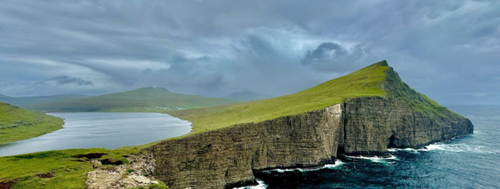
Trælanípa, the so‑called Slave Cliff, is the Faroe Islands at full volume: a clean, perpendicular rock wall rising around 142 meters above the Atlantic Ocean, a cliff-edge path that makes hearts thump, and that famous optical illusion of Lake Sørvágsvatn (also called Leitisvatn) floating high above the sea. It’s not magic—just the knack of perspective from a specific angle—but the mind still blinks when you see water apparently hovering over more water. Travelers come to Vágoy (Vágar) for this one view and walk away muttering, all dazed and grinning, that it looked impossible.
Beyond the postcard moment, Trælanípa delivers something quieter too: the whirr of seabirds and the soft thud of boots on spongy grass, the wind surfacing from nowhere, the sound of Bøsdalafossur waterfall as it pours directly into the Atlantic at the end of the lake. The Faroese name Trælanípa translates as Slave Cliff, a stark nod to a Viking Age story that disobedient thralls were pushed off this very edge. Whether the legend is precise or not, the place carries weight; it’s beautiful, yes, but also raw and a little solemn.
The hike to the Trælanípa cliff viewpoint is relatively easy by mountain standards—mostly a gentle path along the lake—yet it’s not a stroll in the park either. Expect uneven turf, often muddy after rain, and gusts that come in sideways. The route is managed with a hiking fee that funds trail maintenance and conservation. For most visitors, it’s 45–60 minutes each way to the main viewpoint (approximately 6–7 km round trip, 120–150 m of elevation gain), with an optional spur to Bøsdalafossur. Those extra minutes are worth it; watching a lake empty into the ocean through a rock cleft doesn’t happen every day.
From the cliff, the panorama stretches toward Hestur and Koltur, with the southern edge of Streymoy stepping into the horizon on clear days. Farther west, the legendary sea stacks of Drangarnir stand guard near Vágar’s coast—close enough to tease the imagination even if they’re best visited on a dedicated hike or boat trip. Gásadalur and its much-photographed Múlafossur waterfall are a short drive away, making Trælanípa part of a powerful day out on Vágar Island.
Heights and weather are the twin realities here. This is a sheer drop; the wind can be feisty even on “calm” days, and fog rolls in like a curtain. On a first visit, this writer remembers crouching a little as a gust gripped his jacket, then laughing because the view, when the cloud lifted, was worth all the theatrics. Visitors should plan like hikers—sturdy boots, layers, waterproofs, and respect for cliff edges—and enjoy like photographers, because the light skimming across the lake at golden hour is flat-out gorgeous.
Expect polite signage, well-marked paths, and local stewardship. English is widely spoken across the Faroes, card payments are the norm, and the path is under active care. It’s a top-tier site, and yes, that means it can get busy in peak summer mid-day. Early and late visits create the breathing space this landscape deserves.
Key Features
- Floating Lake illusion: The classic viewpoint where Lake Sørvágsvatn (Leitisvatn) appears to hover over the Atlantic Ocean—an optical illusion created by height and angle.
- Perpendicular rock wall: Trælanípa is a near-vertical cliff roughly 142 m high, delivering heady, dramatic views without technical climbing.
- Bøsdalafossur waterfall: A short extension from the main trail reveals the lake’s outflow plunging directly into the ocean—a rare lake-to-sea waterfall.
- Manageable hike: About 6–7 km round trip, 1.5–2.5 hours total for most walkers, with modest elevation and a clear, maintained path.
- Wildlife and birdlife: Fulmars and other seabirds cut the air below the cliffs; sheep (naturally) manage the grass with quiet efficiency.
- Historic name and lore: Trælanípa translates as Slave Cliff, a name dating to the Viking Age and the lore of punishment at the precipice.
- Photographer’s dream: Golden hour lights the lake and ocean in layers; mist and moving weather can create dramatic, moody frames.
- Nearby icons: Practical day-trip pairings with Gásadalur and Múlafossur; glimpses toward Hestur, Koltur, and the southern tip of Streymoy.
- Trail stewardship: A hiking fee and managed access support conservation, reduce erosion, and help keep the experience safe and sustainable.
- Facilities and access: Seasonal staff, clear signage, and simple amenities near the trailhead make planning straightforward.
Best Time to Visit
Technically, Trælanípa can be visited year-round, but the experience shifts with season and light. Summer (June–August) brings long days—late sunsets and early sunrises—and hillsides that look freshly brushed green. It’s the most popular time, and for good reason: stable-ish weather, the best chance of views, and a landscape that just seems to expand under big sky. The trade-off is busier trails mid-day. If summer is your window, aim for sunrise or late evening to dodge crowds and catch softer light; you’ll thank yourself a hundred times over.
Spring and autumn are sweet spots. Shoulder-season light can be magnificent: quick-moving clouds, occasional sunbursts, and fewer walkers. The path can be wet after rain, and winds can be spicy, so bring a proper shell and boots with grip. Photographers often prefer these months for mood and texture—“perfect blue sky” isn’t always the goal in the Faroes.
Winter is wild and can be wonderful, but it’s not guaranteed-tea-and-biscuits. Short days, frequent storms, ice on the trail, and fierce gusts are common. If visiting in winter, build in flexibility and a Plan B. Traction aids, warm layers, and caution near cliff edges are non-negotiable. The upside? When the skies part, the low sun transforms everything into gold and ember; it’s haunting.
A quick note on closures: the Faroe Islands occasionally organize a spring volunteer weekend dubbed “Closed for Maintenance, Open for Voluntourism,” when selected paths are rested and repaired. Trælanípa may be affected. It’s short and well-publicized, and it helps keep extraordinary places extraordinary.
How to Get There
Trælanípa sits on the island of Vágar, the same island as the Faroe Islands’ only airport. Getting there is refreshingly simple.
From Vágar Airport: It’s a short drive to the village of Miðvágur, where the trailhead for Trælanípa is located near the lake’s southern shore. Follow local signage for the managed path. Allow extra time in high season for check-in at the gate and to find parking.
From Tórshavn: By car, the drive takes about 45 minutes via the subsea tunnel to Vágar. The road is straightforward and scenic. If traveling by public bus, route 300 runs between Tórshavn and Vágar; alight in or near Miðvágur and add a walk to the trailhead. Buses are reliable but less frequent outside commuting hours, so check times and plan the return before you go.
By organized tour: Several local operators offer guided hikes that include transportation, which can be a stress saver when weather is on the move. A local guide is especially helpful if you want timing and vantage points tuned to photography or if you’re traveling in winter.
Trail overview: Once on the path, the route follows the lake’s edge on a gentle incline. It’s mostly turf and gravel with boardwalk sections. Near the final viewpoint, a short, steeper section and wooden steps lead to the cliff-top plateau. From there, walk a little farther to position the classic floating-lake composition—your eye will tell you when you’ve got the angle right. Add the spur to Bøsdalafossur by continuing along the lake’s outflow to the sea; allow another 20–30 minutes round trip for the detour.
Arrival logistics: The hike is on private land under local management with a set hiking fee. Payment is typically by card. Visiting slots may be controlled during busy periods to spread footfall and protect the path. Facilities at the trailhead are basic but sensible, and the staff are friendly and happy to answer quick questions about conditions. English is widely spoken, and signage is clear.
Getting to the Faroe Islands: Most visitors fly to Vágar from Copenhagen, Reykjavik, Bergen, or other seasonal hubs. There’s also the Smyril Line ferry from Hirtshals in Denmark to Tórshavn—roughly 36 hours—popular with road-trippers who bring their own car. Either way, once you’re here, Trælanípa is one of the easiest major hikes to reach.
Tips for Visiting
Trælanípa is as straightforward as Faroese blockbusters get, but the cliffs demand sensible prep. A few field-tested tips:
- Dress like a hiker: Waterproof jacket, warm mid-layer, hat, gloves, and solid boots with grip. The wind can change from flirtatious to full-on in a minute. Dont let sneakers and cotton be the reason you turn around early.
- Check the weather and go with margins: Wind is the key variable. If the forecast is rough, pick a calmer window or choose a lower, inland walk. If you go anyway, stay well back from edges—gusts are no joke here.
- Respect the edge: There’s no fence at the cliff-top for good reason. Keep a body length or two away, especially in wet or icy conditions. Kneel for photos if you want the shot without the wobble, and look out for others.
- Time your visit for best light and fewer people: Early morning or late evening creates a quieter trail and better photos. Mid-day is the busiest span in summer.
- Bring small essentials: Water, a thermos, a snack, and a phone with a charged battery. There’s patchy signal in some pockets, but you’re rarely far from help. A lightweight sit pad can make those windy photo waits surprisingly comfy.
- Mind the optical illusion: The floating-lake effect appears from a specific angle toward the cliff’s southern edge. If it isn’t “popping,” shift position along the rim—ten meters can change everything. The illusion isn’t about tide; it’s about perspective.
- Add the waterfall spur: Bøsdalafossur completes the story of the lake flowing directly into the Atlantic. Keep an eye on footing near the outflow, which can be slick.
- Expect a hiking fee and appreciate the why: The managed access helps maintain the path, reduce erosion, and protect wildlife. Bring a bank card and your patience; a queue in peak times just means the trail is being cared for.
- Pack out your litter and stay on the path: The turf heals slowly. Following the marked route keeps the landscape wild and gorgeous for the next traveler.
- Photography notes: A wide-angle lens emphasizes the cliff and lake; a mid-tele compresses the “hovering over the ocean” effect. If the scene is fogged in, wait 15–20 minutes—weather flips fast, and you might get that cinematic reveal.
- Drones and birds: If flying is allowed on the day, give nesting birds generous space and avoid cliff faces. Wind here can toss drones around like paper planes.
- Traveling with kids: The path itself is manageable, but keep young walkers well back from the edge and consider holding hands on the cliff-top. The final stairs can feel exposed in strong wind.
- Language and etiquette: Faroese and Danish are official languages, but English is widely understood. A friendly nod, a takk (thanks), and sticking to the rules go a long way.
- Pair your day: After Trælanípa, drive to Gásadalur for Múlafossur’s seaward plunge or book a boat trip to glimpse Drangarnir’s sea arch. It’s a compact island—smart planning lets you stack big sights without rushing.
If you’re curious about the hike length, think in ballpark numbers: about 6–7 km round trip, 1.5–2.5 hours with stops, plus extra time for photos and the waterfall spur. Many travelers take longer because it’s the kind of view that steals minutes without asking.
A final aside from the trail: once, waiting out a stubborn cloud, this writer watched a line of sheep cross the path like they owned the place (which, arguably, they do). Then the wind shifted, the lake lifted into view, the ocean dropped beneath it, and a small group of hikers just went quiet. Not staged, not overloaded, just real. Trælanípa doesn’t need superlatives; it does the talking if visitors give it the time.
Location
Places to Stay Near Trælanípa
Find and Book a Tour
Explore More Travel Guides
No reviews found! Be the first to review!