The Azuaje Ravine stands as one of Gran Canaria’s most remarkable hidden treasures, tucked away in the northern part of the island near Firgas. This stunning gorge cuts dramatically through the landscape, creating a verdant oasis that feels worlds apart from the typical Canarian scenery most travelers expect. And honestly? That’s exactly what makes it so special.
What strikes you first about Azuaje is just how green everything is. The ravine walls tower above you, draped in ancient laurel forests that have somehow survived since the Tertiary Era – we’re talking millions of years here. These aren’t your average trees; they’re living remnants of the once-mighty Doramas Forest that covered much of northern Gran Canaria centuries ago.
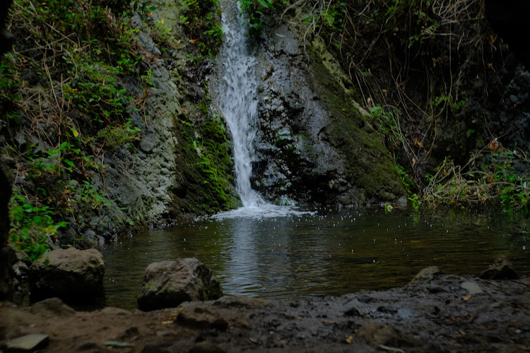
Crystal-clear streams weave through the ravine floor, creating a symphony of water sounds that’ll make you forget you’re on a volcanic island in the Atlantic. The waterfalls here aren’t massive thundering cascades, but rather gentle, moss-covered drops that create perfect natural pools. I’ve always found there’s something almost magical about the way the light filters through the canopy and dances on the water below.
The ravine serves as a natural boundary between two municipalities – Moya and Firgas – and it’s protected as a Special Nature Reserve. This designation means the ecosystem remains largely untouched, preserving habitats that are increasingly rare in the Canary Islands. The microclimate here stays refreshingly cool and humid year-round, creating conditions that support plant species you simply won’t find elsewhere on the island.
Key Features
Azuaje Ravine offers visitors a collection of distinctive features that make it stand out among Gran Canaria’s natural attractions:
- Ancient Laurel Forests: These prehistoric woodlands represent some of the last remaining fragments of the legendary Doramas Forest, featuring endemic species that have adapted to the unique microclimate over thousands of years
- Natural Water Features: Multiple streams converge throughout the ravine, creating cascading waterfalls and crystal-clear pools that maintain consistent water levels even during dry periods
- Dramatic Rock Formations: The steep ravine walls rise impressively on both sides, carved by centuries of water erosion and showcasing the island’s volcanic geological history through exposed rock layers
- Endemic Flora and Fauna: The protected environment supports rare plant species including ancient ferns, native mosses, and climbing vines that create a jungle-like atmosphere unique to this northern microclimate
- Historical Irrigation Channels: Traditional water management systems still visible throughout the area demonstrate centuries-old Canarian agricultural techniques and the ravine’s importance to local communities
- Photography Opportunities: The interplay of light and shadow through the forest canopy, combined with moss-covered rocks and flowing water, creates countless picture-perfect moments
- Circular Hiking Routes: Well-maintained trails offer various difficulty levels, allowing visitors to explore different sections of the ravine while experiencing diverse ecosystems and viewpoints
Best Time to Visit
Here’s the thing about Azuaje – it’s genuinely beautiful year-round, but there are definitely better times to experience it at its peak. The ravine’s protected location and consistent water sources mean it stays green even when other parts of Gran Canaria turn brown during dry spells.
Winter months from November through March offer the most comfortable hiking conditions. Temperatures hover around 18-22°C (64-72°F), and you’ll often have the trails mostly to yourself. The waterfalls run strongest during this period too, thanks to increased rainfall in the mountains above. But don’t worry about getting soaked – the forest canopy provides excellent natural shelter.
Spring (April and May) is absolutely magical here. Everything comes alive with new growth, and wildflowers add splashes of color throughout the forest floor. The weather’s perfect for longer hikes, and you might even spot some of the endemic bird species that call this place home.
Summer can be trickier. While the ravine stays cooler than the coast, humidity levels rise significantly. Early morning visits work best if you’re traveling between June and September – aim to start your hike by 8 AM to avoid both heat and crowds. Plus, morning light filtering through the laurel canopy creates some truly spectacular photo opportunities.
Autumn brings its own rewards. September and October often see fewer tourists, but weather conditions remain ideal for hiking. The streams run clear and steady, and there’s something peaceful about having these ancient forests almost to yourself.
One tip I’ve learned from experience: check recent weather conditions before visiting. While the ravine handles light rain well, heavy storms can make stream crossings dangerous and trails slippery. Local weather can differ significantly from coastal forecasts, so it’s worth asking at your accommodation about current conditions in the mountains.
How to Get There
Getting to Azuaje Ravine requires a bit of planning, but it’s definitely manageable whether you’re driving or using public transport. The main access point is through the town of Firgas, which sits about 25 kilometers from Las Palmas.
If you’re renting a car – which I’d honestly recommend for this trip – take the GC-20 highway north from Las Palmas towards Arucas, then follow signs to Firgas. The drive takes roughly 35-40 minutes depending on traffic. Once you reach Firgas town center, look for signs pointing toward “Barranco de Azuaje” or “Reserva Natural Especial de Azuaje.”
Parking can be a bit challenging, especially on weekends. There’s a small parking area near the main trailhead, but it fills up quickly. Local residents have gotten understandably frustrated with inconsiderate parking, so please respect designated areas and don’t block driveways or narrow streets. If the main lot is full, you might need to park in Firgas town and walk about 15-20 minutes to reach the trailhead.
For those using public transport, bus line 210 runs from Las Palmas to Firgas several times daily. The journey takes about an hour, and you’ll need to walk from the Firgas bus station to the ravine entrance – it’s roughly a 25-minute walk through town. While not the most convenient option, it’s certainly doable and gives you a chance to explore Firgas itself, which has some charming traditional architecture.
Some visitors choose to join organized hiking tours that include transportation. These typically depart from major tourist areas and include a guide who can share insights about the local ecology and history. It’s more expensive than going independently, but removes the stress of navigation and parking.
Fair warning: GPS systems sometimes struggle with the smaller roads around the ravine entrance. Download offline maps beforehand, and don’t be afraid to ask locals for directions – most are happy to help, especially if you attempt a few words in Spanish.
Tips for Visiting
After several visits to Azuaje over the years, I’ve picked up some practical insights that can make your experience much more enjoyable. First things first – wear proper hiking shoes with good grip. The trails can be slippery, especially near water features, and those smooth-soled sneakers that work fine on city streets will have you sliding around like you’re on ice.
Bring more water than you think you’ll need. Yes, there are streams throughout the ravine, but drinking untreated water isn’t worth the risk of ruining your vacation. A good rule of thumb is at least one liter per person for shorter hikes, more if you’re planning to explore extensively or visit during warmer months.
Pack layers, even if it looks sunny when you leave your hotel. The temperature difference between the coast and the ravine can be surprising – I’ve seen visitors shivering in t-shirts they wore comfortably at the beach just an hour earlier. A light jacket or fleece weighs almost nothing but can make your hike much more comfortable.
Photography enthusiasts should bring a tripod if possible. The forest canopy creates beautiful but challenging lighting conditions, and some of the most stunning shots require longer exposures to capture the movement of water over rocks. Also, consider bringing lens cleaning supplies – the humidity can fog up equipment quickly.
The trails are generally well-marked, but it’s easy to get turned around in some sections where paths intersect. Take photos at major trail junctions on your way in, so you can reference them on your return journey. And please, please stay on designated trails. The ecosystem here is fragile, and shortcuts cause erosion damage that takes years to repair.
If you’re traveling with children, this can be an excellent family adventure, but manage expectations accordingly. The terrain isn’t technically difficult, but it does require attention and care. Kids often love the stream crossings and waterfall areas, but supervise them closely around wet rocks.
Timing your visit matters more than you might expect. Weekends bring local families and hiking groups, which adds to the atmosphere but can mean crowded trails and full parking areas. Weekday mornings offer the best chance for a more solitary experience with nature.
Finally, respect the environment and local communities. This isn’t a theme park – it’s a protected ecosystem and part of people’s daily lives. Pack out all trash, keep noise levels reasonable, and remember that this special place exists because previous generations chose to preserve it rather than develop it.
 Real Journey Travels