Mdimba
About Mdimba
Description
Mdimba, often written as Mdzimba, is the mountain and hill range that frames the eastern side of Eswatini’s famed Ezulwini Valley—literally the Valley of Heaven. It stands watch over Mbabane, the country’s administrative capital, and looks down toward Lobamba, the seat of the monarchy and the legislature. That detail alone gives the range a special aura: the ridgeline connects dramatic scenery with living history. Travelers who come for a “peak in Eswatini” tend to expect a quick photo stop. They eventually linger, drawn in by big-sky views, the smell of sun-warmed grass, and stories locals share about caves and ancient hideouts. The result? A mountain that quietly steals the show in the Hhohho Region without any fuss.
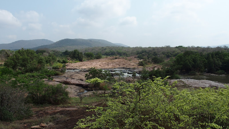
Geographically, Mdimba belongs to Eswatini’s highveld, a cooler upland that rolls in waves of granite and montane grassland. The slopes rise above Mbabane’s average elevation of around 1,200 meters and range up into rocky knuckles that scrape at cloud bases on winter mornings. The Mbabane River and its tributary the Polinjane River carve the saddles and gullies, leaving a geography of boulder gardens, quartz-like shards in the dust, and occasional cliffs where raptors hang on the wind. When the summer rains arrive, the grass brightens almost overnight and wildflowers pop from the verges in improbable reds and yellows. And yes, during July or August, frost paints the path at dawn, and the air has that metallic bite that hikers either love or grumble about in the first ten minutes of a climb.
The range isn’t only good-looking; it’s loaded with cultural significance too. The Ezulwini Valley below houses the Ludzidzini Royal Residence, and Lobamba is the location for national ceremonies. People often ask why Eswatini has two capitals. In short: Mbabane is the capital for administration—the government offices, embassies, business; Lobamba is also the capital for the monarchy and parliament. Mdimba—and the wider Mdzimba ridge—hover between the two, literally and symbolically, which is why the mountain features in oral histories, legends, and the practical, everyday lives of the Swazi people. Herders still thread paths up to higher grazing. Families gather thatch on permitted slopes. On certain ridges, elders will point out clefts in the rock said to be used as refuge or lookouts in long-ago conflicts. Those aren’t museum labels; they’re lived memory.
From a traveler’s perspective, the first thing that registers is the panorama. The ridge serves up a 180-degree sweep over the Ezulwini Valley to Mlilwane Wildlife Sanctuary, and on a day with crisp winter air, the line of the Ngwenya highlands (and the old iron ore scars by the historic Ngwenya Mine) is visible far to the west. On other days you’ll see the valley shimmering in heat, studded with craft markets, homesteads, and specks of cattle moving like marbles down dirt tracks. Stay a while and the light changes minute to minute, washing Lobamba’s ceremonial grounds in gold, then shadow, then a pink flare at sunset. Photographers live for this. And honestly, so do hikers who only ever use their phone cameras.
Wildlife here is about the small and sharp-eyed. Think rock hyrax (dassies) balled up on granite ledges and vervet monkeys springing across the canopy in giggling troops. Birders get their treat list: jackal buzzard, booted eagle, and the occasional crowned eagle patrolling the thermals over the river in the Mdzimba mountains. In the warmer months, sunbirds and sugarbirds chase the nectar of proteas and aloes. It’s not a Big Five destination; it’s a highveld tapestry that rewards patience—look down for the tracks, look up for the wing shadows, and keep an ear tuned for the chuckle of a Polinjane tributary finding its way through reeds.
One of the joys of Mdimba is how close it sits to real life. Mbabane is the capital and lies on the Mbabane River, so a climb can start only a short drive from the city center. This proximity means travelers can stay in Mbabane, grab breakfast before dawn, and be watching first light skip across the ridge by the time the coffee wears off. The city’s cool climate—shaped by its altitude—means even summer hikes start pleasantly, and the range offers a handful of intuitive routes that stick to cattle tracks and old footpaths. Some sections are steep and faint; local guides earn their fee by keeping hikers away from crumbly gullies and getting them onto the fun stuff early—ridges lined with quartz pebbles, boulder scrambles where handholds are clean and solid, and pockets of shade where a breeze seems to pour from nowhere.
Culture and conversation flow almost as freely as the views. Siswati (sometimes written as siSwati) is the most widely spoken language, and hearing sawubona and yebo exchanged on the trail is part of the rhythm. You’ll notice hikers and herders greeting; it’s expected and also just nice. Travelers curious about the country’s identity often learn a handful of quick facts: residents are Swazi, the largest city is Manzini, and the economy runs on a complex mix of tourism and sugar exports, with threads of manufacturing and long-ago mining of tin and iron in the wider highveld. Those facts may sound a bit textbook, but on Mdimba they take on color—tourism becomes the family-run guesthouse down in the valley, sugar is the long-haul truck on MR3 humming east, and history is the elder who points a hardwood staff at a rock shelter and says, “This is where my grandfather used to take the goats when the big storms came.”
The mountain’s character changes with the weather and season. Summer builds storms in slow-motion drama; by mid-afternoon, clouds muscle in, and it can pour with a bottomless, drumming energy. The rain is usually brief. Trails get slick, but the smell of wet grass and granite is something special. In winter, mornings can be brisk. On rare days, a white hush coats the ridge, more frost than snow, but every now and then a dusting will make local headlines. It’s part of the draw: Mdimba is not a static postcard; it shape-shifts with the sky.
Visitors who like their travel layered—landscape, people, stories—tend to make Mdimba a base for a wider Ezulwini Valley circuit. A morning spent hiking and glassing the valley rolls naturally into an afternoon at craft markets, or a visit to nearby cultural sites in Lobamba when events align. On certain dates, the valley hosts major ceremonies that draw crowds; at these times, logistics require a bit of planning, and pathways on the lower slopes may feel more lived-in than wild. It’s not a problem, just part of the mountain’s identity: a place that belongs to local life first and welcomes guests second.
Let’s talk access and orientation for a moment, because no one likes confusion at a trailhead. Mdimba sits in the district of Hhohho, often described simply as the Hhohho Region, and its foothills are a short hop from Mbabane via the MR3. From the west, Mbabane’s closest border crossing to South Africa is the Ngwenya-Oshoek gate; travelers arriving from Johannesburg or Nelspruit can reach the range in roughly 25–40 minutes after clearing the border, depending on traffic and how quickly the mountains lure a stop for photos. From Manzini—also the capital of commerce in many locals’ minds—the drive is typically under an hour, running westward through rolling highveld until the landscape tilts up into rock and sky.
Here’s what the mountain actually feels like underfoot: the first steps take you through homesteads and fields where chickens scratch and dogs do that happy half-bark at strangers. Then the path gathers, tightens, and the gradient rises. You’ll pass termite mounds and aloe clumps, then slip under pockets of wattle or gum. A little higher, the canopy thins, and the wind starts to talk against the ears. Stone slabs appear, cool and rough, and the path swings around a granitic knuckle to spill you onto a spur with Ezulwini laid out like a relief map. Wear good shoes because the descent is where knees complain. That said, the terrain is forgiving enough for hikers with moderate fitness. Families who are used to weekend walks do well if they plan turnaround times and bring a proper layer for surprise gusts.
One small but important reality check: signage isn’t standardized. This isn’t a fenced park with boardwalks. Some routes cross communal land, and permission or a quick chat with locals goes a long way. A guide is recommended for first-time visitors, not because Mdimba is confusing, but because a guide translates the landscape—from place names to plants to the stories that make a ridge more than just rock and grass. Guides will also steer you toward safer viewpoints and away from steep drops that the camera lens can make look deceptively tame. Common sense rules apply: leave no litter, close gates you open, and be mindful that homesteads are not tourist attractions; they’re people’s lives.
Food and water: the mountain doesn’t have shops, obviously, and the streams—especially those fed by the Polinjane River in the Mdzimba—aren’t reliable for casual drinking without treatment. Carry sufficient water. The highveld can surprise with dry air, and hikers often underestimate how much they’ll drink on what looks like a mild morning. Pack a hat, sunscreen, and a lightweight shell. Rain can arrive out of nowhere. When it does, turn the surprise into a short break, breathe in the petrichor, and wait for the light show that tends to follow when clouds tear open and the valley shines like it’s been polished.
Another small delight: the soundscape. On still days, you’ll hear cowbells and distant laughter. On windier days, it’s the hiss of grass and the sudden clatter of guinea fowl lifting en masse. If the breeze is right, a drumbeat from the valley can roll up the slopes in a way that makes time feel fuzzy—like the mountain remembers every ceremony ever held below it. For travelers chasing a sense of place—something beyond a viewpoint—Mdimba delivers these tiny, telling moments by the handful.
Given how close the range is to Mbabane and Lobamba, many travelers combine a Mdimba hike with a city experience. Mbabane is located on the slopes to the west, and its markets, galleries, and cafes serve as a tidy pre- or post-hike base. Some days, the itinerary looks like this: sunrise on the ridge, coffee and a pastry in the city, afternoon wandering the Ezulwini craft stalls, and sundowners watching the valley fall into silhouette from a roadside pull-off. No rush, no stress. Also the capital cities being so near means transport is straightforward—taxis know the foothills roads and will quote a flat fare for drop-off and pick-up. Just confirm the return time before heading out. Mobile coverage is decent but spotty in gullies.
For the trivia inclined (there’s always a few, and we love them): Mdimba SZ Eswatini tends to appear on maps using both the Mdzimba and Mdimba spellings; both refer to the same ridge system flanking the Ezulwini Valley’s eastern side. The Polinjane River in the Mdzimba is regarded as a tributary of the Mbabane River and contributes to the water that eventually heads toward the country’s larger systems. The city has two sites that regularly make guidebooks—Mbabane’s markets and Lobamba’s cultural venues—and both are visible from different points on the ridge if you know where to look. Finally, on good days, hikers like to say they can “see the sugar” to the east, referring to plantations in the mid- and lowveld; on best days, you’ll swear the highveld rolls forever.
Mdimba’s magic isn’t framed by railings or served behind ticket windows. It’s a living mountain in the Hhohho Region where the human scale of Eswatini plays out in full: greetings on the trail, kids walking to school, herds moving with the weather, ceremonies lighting the valley, and hikers coming for a view and leaving with a feeling. If a place can be both modest and mighty, this is it. Come with curiosity, a fair pair of boots, and the easy respect that any wild-ish place expects. The mountain will do the rest.
Key Features
- Prominent ridge overlooking Ezulwini Valley with panoramic viewpoints
- Cultural and historical significance in Swazi oral tradition and royal proximity
- Accessible hiking paths and short day routes suitable for moderate fitness
- Diverse montane flora and local birdwatching opportunities
- Close to Mbabane and Lobamba making it easy to combine with cultural visits
More Details
Updated October 12, 2025
Table of Contents
Description
Mdimba, often written as Mdzimba, is the mountain and hill range that frames the eastern side of Eswatini’s famed Ezulwini Valley—literally the Valley of Heaven. It stands watch over Mbabane, the country’s administrative capital, and looks down toward Lobamba, the seat of the monarchy and the legislature. That detail alone gives the range a special aura: the ridgeline connects dramatic scenery with living history. Travelers who come for a “peak in Eswatini” tend to expect a quick photo stop. They eventually linger, drawn in by big-sky views, the smell of sun-warmed grass, and stories locals share about caves and ancient hideouts. The result? A mountain that quietly steals the show in the Hhohho Region without any fuss.
Geographically, Mdimba belongs to Eswatini’s highveld, a cooler upland that rolls in waves of granite and montane grassland. The slopes rise above Mbabane’s average elevation of around 1,200 meters and range up into rocky knuckles that scrape at cloud bases on winter mornings. The Mbabane River and its tributary the Polinjane River carve the saddles and gullies, leaving a geography of boulder gardens, quartz-like shards in the dust, and occasional cliffs where raptors hang on the wind. When the summer rains arrive, the grass brightens almost overnight and wildflowers pop from the verges in improbable reds and yellows. And yes, during July or August, frost paints the path at dawn, and the air has that metallic bite that hikers either love or grumble about in the first ten minutes of a climb.
The range isn’t only good-looking; it’s loaded with cultural significance too. The Ezulwini Valley below houses the Ludzidzini Royal Residence, and Lobamba is the location for national ceremonies. People often ask why Eswatini has two capitals. In short: Mbabane is the capital for administration—the government offices, embassies, business; Lobamba is also the capital for the monarchy and parliament. Mdimba—and the wider Mdzimba ridge—hover between the two, literally and symbolically, which is why the mountain features in oral histories, legends, and the practical, everyday lives of the Swazi people. Herders still thread paths up to higher grazing. Families gather thatch on permitted slopes. On certain ridges, elders will point out clefts in the rock said to be used as refuge or lookouts in long-ago conflicts. Those aren’t museum labels; they’re lived memory.
From a traveler’s perspective, the first thing that registers is the panorama. The ridge serves up a 180-degree sweep over the Ezulwini Valley to Mlilwane Wildlife Sanctuary, and on a day with crisp winter air, the line of the Ngwenya highlands (and the old iron ore scars by the historic Ngwenya Mine) is visible far to the west. On other days you’ll see the valley shimmering in heat, studded with craft markets, homesteads, and specks of cattle moving like marbles down dirt tracks. Stay a while and the light changes minute to minute, washing Lobamba’s ceremonial grounds in gold, then shadow, then a pink flare at sunset. Photographers live for this. And honestly, so do hikers who only ever use their phone cameras.
Wildlife here is about the small and sharp-eyed. Think rock hyrax (dassies) balled up on granite ledges and vervet monkeys springing across the canopy in giggling troops. Birders get their treat list: jackal buzzard, booted eagle, and the occasional crowned eagle patrolling the thermals over the river in the Mdzimba mountains. In the warmer months, sunbirds and sugarbirds chase the nectar of proteas and aloes. It’s not a Big Five destination; it’s a highveld tapestry that rewards patience—look down for the tracks, look up for the wing shadows, and keep an ear tuned for the chuckle of a Polinjane tributary finding its way through reeds.
One of the joys of Mdimba is how close it sits to real life. Mbabane is the capital and lies on the Mbabane River, so a climb can start only a short drive from the city center. This proximity means travelers can stay in Mbabane, grab breakfast before dawn, and be watching first light skip across the ridge by the time the coffee wears off. The city’s cool climate—shaped by its altitude—means even summer hikes start pleasantly, and the range offers a handful of intuitive routes that stick to cattle tracks and old footpaths. Some sections are steep and faint; local guides earn their fee by keeping hikers away from crumbly gullies and getting them onto the fun stuff early—ridges lined with quartz pebbles, boulder scrambles where handholds are clean and solid, and pockets of shade where a breeze seems to pour from nowhere.
Culture and conversation flow almost as freely as the views. Siswati (sometimes written as siSwati) is the most widely spoken language, and hearing sawubona and yebo exchanged on the trail is part of the rhythm. You’ll notice hikers and herders greeting; it’s expected and also just nice. Travelers curious about the country’s identity often learn a handful of quick facts: residents are Swazi, the largest city is Manzini, and the economy runs on a complex mix of tourism and sugar exports, with threads of manufacturing and long-ago mining of tin and iron in the wider highveld. Those facts may sound a bit textbook, but on Mdimba they take on color—tourism becomes the family-run guesthouse down in the valley, sugar is the long-haul truck on MR3 humming east, and history is the elder who points a hardwood staff at a rock shelter and says, “This is where my grandfather used to take the goats when the big storms came.”
The mountain’s character changes with the weather and season. Summer builds storms in slow-motion drama; by mid-afternoon, clouds muscle in, and it can pour with a bottomless, drumming energy. The rain is usually brief. Trails get slick, but the smell of wet grass and granite is something special. In winter, mornings can be brisk. On rare days, a white hush coats the ridge, more frost than snow, but every now and then a dusting will make local headlines. It’s part of the draw: Mdimba is not a static postcard; it shape-shifts with the sky.
Visitors who like their travel layered—landscape, people, stories—tend to make Mdimba a base for a wider Ezulwini Valley circuit. A morning spent hiking and glassing the valley rolls naturally into an afternoon at craft markets, or a visit to nearby cultural sites in Lobamba when events align. On certain dates, the valley hosts major ceremonies that draw crowds; at these times, logistics require a bit of planning, and pathways on the lower slopes may feel more lived-in than wild. It’s not a problem, just part of the mountain’s identity: a place that belongs to local life first and welcomes guests second.
Let’s talk access and orientation for a moment, because no one likes confusion at a trailhead. Mdimba sits in the district of Hhohho, often described simply as the Hhohho Region, and its foothills are a short hop from Mbabane via the MR3. From the west, Mbabane’s closest border crossing to South Africa is the Ngwenya-Oshoek gate; travelers arriving from Johannesburg or Nelspruit can reach the range in roughly 25–40 minutes after clearing the border, depending on traffic and how quickly the mountains lure a stop for photos. From Manzini—also the capital of commerce in many locals’ minds—the drive is typically under an hour, running westward through rolling highveld until the landscape tilts up into rock and sky.
Here’s what the mountain actually feels like underfoot: the first steps take you through homesteads and fields where chickens scratch and dogs do that happy half-bark at strangers. Then the path gathers, tightens, and the gradient rises. You’ll pass termite mounds and aloe clumps, then slip under pockets of wattle or gum. A little higher, the canopy thins, and the wind starts to talk against the ears. Stone slabs appear, cool and rough, and the path swings around a granitic knuckle to spill you onto a spur with Ezulwini laid out like a relief map. Wear good shoes because the descent is where knees complain. That said, the terrain is forgiving enough for hikers with moderate fitness. Families who are used to weekend walks do well if they plan turnaround times and bring a proper layer for surprise gusts.
One small but important reality check: signage isn’t standardized. This isn’t a fenced park with boardwalks. Some routes cross communal land, and permission or a quick chat with locals goes a long way. A guide is recommended for first-time visitors, not because Mdimba is confusing, but because a guide translates the landscape—from place names to plants to the stories that make a ridge more than just rock and grass. Guides will also steer you toward safer viewpoints and away from steep drops that the camera lens can make look deceptively tame. Common sense rules apply: leave no litter, close gates you open, and be mindful that homesteads are not tourist attractions; they’re people’s lives.
Food and water: the mountain doesn’t have shops, obviously, and the streams—especially those fed by the Polinjane River in the Mdzimba—aren’t reliable for casual drinking without treatment. Carry sufficient water. The highveld can surprise with dry air, and hikers often underestimate how much they’ll drink on what looks like a mild morning. Pack a hat, sunscreen, and a lightweight shell. Rain can arrive out of nowhere. When it does, turn the surprise into a short break, breathe in the petrichor, and wait for the light show that tends to follow when clouds tear open and the valley shines like it’s been polished.
Another small delight: the soundscape. On still days, you’ll hear cowbells and distant laughter. On windier days, it’s the hiss of grass and the sudden clatter of guinea fowl lifting en masse. If the breeze is right, a drumbeat from the valley can roll up the slopes in a way that makes time feel fuzzy—like the mountain remembers every ceremony ever held below it. For travelers chasing a sense of place—something beyond a viewpoint—Mdimba delivers these tiny, telling moments by the handful.
Given how close the range is to Mbabane and Lobamba, many travelers combine a Mdimba hike with a city experience. Mbabane is located on the slopes to the west, and its markets, galleries, and cafes serve as a tidy pre- or post-hike base. Some days, the itinerary looks like this: sunrise on the ridge, coffee and a pastry in the city, afternoon wandering the Ezulwini craft stalls, and sundowners watching the valley fall into silhouette from a roadside pull-off. No rush, no stress. Also the capital cities being so near means transport is straightforward—taxis know the foothills roads and will quote a flat fare for drop-off and pick-up. Just confirm the return time before heading out. Mobile coverage is decent but spotty in gullies.
For the trivia inclined (there’s always a few, and we love them): Mdimba SZ Eswatini tends to appear on maps using both the Mdzimba and Mdimba spellings; both refer to the same ridge system flanking the Ezulwini Valley’s eastern side. The Polinjane River in the Mdzimba is regarded as a tributary of the Mbabane River and contributes to the water that eventually heads toward the country’s larger systems. The city has two sites that regularly make guidebooks—Mbabane’s markets and Lobamba’s cultural venues—and both are visible from different points on the ridge if you know where to look. Finally, on good days, hikers like to say they can “see the sugar” to the east, referring to plantations in the mid- and lowveld; on best days, you’ll swear the highveld rolls forever.
Mdimba’s magic isn’t framed by railings or served behind ticket windows. It’s a living mountain in the Hhohho Region where the human scale of Eswatini plays out in full: greetings on the trail, kids walking to school, herds moving with the weather, ceremonies lighting the valley, and hikers coming for a view and leaving with a feeling. If a place can be both modest and mighty, this is it. Come with curiosity, a fair pair of boots, and the easy respect that any wild-ish place expects. The mountain will do the rest.
Key Highlights
- Prominent ridge overlooking Ezulwini Valley with panoramic viewpoints
- Cultural and historical significance in Swazi oral tradition and royal proximity
- Accessible hiking paths and short day routes suitable for moderate fitness
- Diverse montane flora and local birdwatching opportunities
- Close to Mbabane and Lobamba making it easy to combine with cultural visits
Location
Places to Stay Near Mdimba
Find and Book a Tour
Explore More Travel Guides
No reviews found! Be the first to review!
Traveler Reviews for Mdimba
There are no reviews yet. Be the first one to write one.
Have you visited Mdimba? Help other travelers by sharing your review.
Nearby Attractions
You Might Also Like
Mbuluzi Game Reserve
House On Fire / Malandelas Restaurant
Find Accommodations Nearby
Recommended Tours & Activities
Visitor Reviews
There are no reviews yet. Be the first one to write one.
Share Your Experience
Have you visited Mdimba? Help other travelers by leaving a review.